

A site engineer on a mid-rise project in Lagos spends three days a month reconciling as-built drawings against site measurements taken by hand. On a project using automated total stations and drone survey, that same reconciliation takes an afternoon. This gap is not theoretical — it is the difference between a project that holds its schedule and one that bleeds days to rework. Automation benefits in construction show up in exactly these moments: fewer manual touchpoints, fewer transcription errors, and faster feedback between design and site.
This article covers what automation actually does on a construction project, where it earns its cost, and where it still falls short. You will see specific processes — surveying, quantity take-off, quality checks, scheduling — and how automation changes each one. The goal is a practical view you can apply to a real project, not a sales pitch for a piece of software.
Automation Benefits: Quick Answer
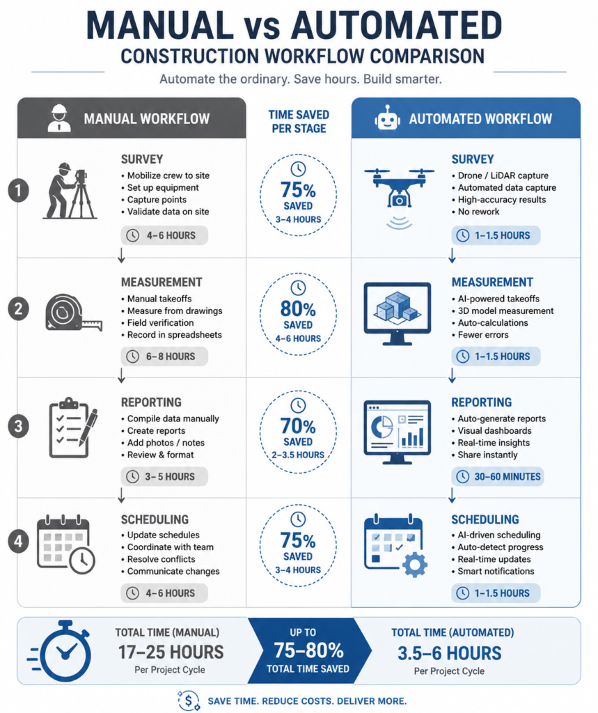
Automation benefits in construction include faster data capture, fewer manual errors, lower rework rates, and better use of skilled labour. Drones cut survey time from days to hours. Automated take-off software reduces quantity errors that typically run 3–5% on manually measured bills of quantities. The result is shorter float consumption and fewer variation claims.
What Automation Means on a Construction Project
Automation is the use of machines, sensors, or software to perform tasks that previously required continuous manual input, with minimal human intervention once the task is running. On a construction site, this spans a wide range: a drone flying a pre-programmed survey grid, a robotic total station that tracks a prism without an operator holding it, software that generates a bill of quantities directly from a BIM model, or a batching plant that mixes concrete to a fixed recipe without a site operator adjusting proportions by eye.
The common thread is repeatability. A human surveyor reading a staff and recording numbers by hand introduces variance every time — fatigue, parallax error, transcription mistakes. An automated total station reads the same point the same way every time, and logs it directly into a digital file. That consistency is where most of the practical value sits, more than any single dramatic productivity claim.
Automation Versus Digitisation
These two terms get confused often, and the confusion leads teams to buy the wrong tool. Digitisation means converting a paper process into a digital one — scanning a drawing, filling a form on a tablet instead of a clipboard. Automation goes further: it removes the human step from the loop entirely, or reduces it to review and approval only. A digitised site diary still needs someone to type the entry. An automated progress report pulls data from site sensors and drone flights and compiles it without anyone typing.
Where Automation Sits in the Project Lifecycle
Automation is not a single tool applied once. It shows up at different stages: automated survey and monitoring during earthworks, automated take-off and estimating during pre-construction, automated scheduling updates during the build, and automated defect detection during handover. Teams that get the most value tend to apply automation across at least two or three of these stages rather than treating it as a one-off purchase for a single department.
Technical Depth: How Automated Processes Actually Work
To evaluate automation benefits honestly, you need to understand what is happening under the tool, not just the marketing claim. Three categories cover most construction automation in use today: data capture automation, computational automation, and physical/robotic automation.
Data Capture Automation
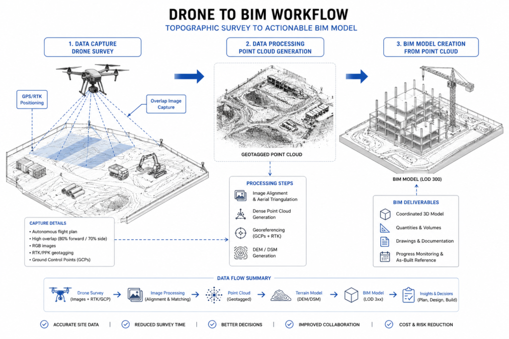
This covers drones (UAVs), laser scanners, and robotic total stations. A drone survey of a 5-hectare site typically takes 20–40 minutes of flight time and produces a point cloud with ground sampling distance of 2–5cm, depending on flight altitude and camera resolution. Compare that to a two-person chain survey team covering the same area over one to two days. The drone does not replace the surveyor’s judgment on boundary interpretation or datum control — it replaces the manual walking and recording.
Laser scanning (terrestrial LiDAR) works similarly for interior or structural surveys, producing millions of measured points per scan versus dozens of manual spot checks. For structural monitoring — tracking settlement or deflection over time — automated total stations can log readings at fixed intervals (hourly, daily) without anyone visiting the site, which matters on projects near sensitive structures where continuous monitoring is a condition of approval.
Computational Automation
This is the software layer: automated quantity take-off from a BIM model, clash detection that runs overnight instead of requiring a coordinator to check every drawing pair manually, and automated scheduling tools that recalculate the critical path when a single activity slips. A BIM model with properly tagged elements can generate a quantity take-off in minutes that would take an estimator one to two days to compile manually from 2D drawings, and it updates automatically when the design changes — a manual take-off has to be redone from scratch.
Physical and Robotic Automation
Less common on West African sites currently, but growing: robotic rebar tying, automated concrete batching and dosing, and 3D-printed formwork or wall elements. Automated batching plants hold mix proportions to tolerances of around 1–2% by weight, which manual batching struggles to match consistently, particularly with admixture dosing where small volume errors change workability and strength development significantly.
Related to this is the growth of automated systems in construction generally, which increasingly overlaps with robotics deployment on active sites, particularly for repetitive tasks like bricklaying and floor screeding.
Regulatory and Practical Context in Nigeria and West Africa
Deploying automation on a Nigerian project involves more than buying equipment. Drone survey work requires clearance from the Nigerian Civil Aviation Authority (NCAA), and operators typically need a Remote Pilot Certificate plus site-specific flight approval, particularly near airports in Lagos, Abuja, or Port Harcourt where controlled airspace restricts flight altitude and radius. Skipping this step is a common reason automation pilots stall — the equipment arrives before the paperwork does.
COREN does not yet regulate automated survey or BIM outputs as a distinct discipline, but the professional responsible for sealing drawings and certifying structural adequacy remains liable regardless of which tool produced the underlying data. This means an automated take-off or a drone-derived topographic survey still needs review and sign-off by a registered engineer or surveyor before it enters the design record — automation speeds up data collection, it does not remove the certification step.
Power reliability is a practical constraint that gets underestimated. Automated batching plants, robotic total stations with continuous logging, and cloud-synced BIM platforms all assume stable power and connectivity. On sites without dependable grid supply, teams typically need a dedicated inverter or generator circuit for automation equipment separate from general site power, because voltage fluctuation damages sensitive sensors and interrupts data logging mid-cycle.
Import duty and equipment cost also shape adoption. A mid-range drone survey package with photogrammetry software can run from ₦2.5 million to ₦8 million depending on camera specification and whether RTK (real-time kinematic) positioning is included for survey-grade accuracy. For contractors running fewer than three or four large projects a year, hiring a specialist survey firm with drone capability often makes more financial sense than owning the equipment outright.
Common Challenges and Cost Factors
Automation is not free of friction, and teams that adopt it without planning for these issues tend to abandon the tools within a year.
- Data volume management: A single drone survey can generate several gigabytes of raw imagery and point cloud data. Without a clear file structure and storage plan, this data becomes unusable within weeks — teams end up back to manual methods simply because nobody can locate the processed output.
- Skills gap: Operating a robotic total station or processing photogrammetry data requires training that most site teams do not have by default. Budget for at least one to two weeks of operator training, plus ongoing software subscription costs that are easy to overlook in an initial capital budget.
- Integration with existing workflows: Automated outputs need to plug into whatever system the design and QS teams already use. A beautifully automated survey that produces a file format nobody else on the project can open adds delay instead of removing it.
- Upfront cost versus project scale: Automation pays back fastest on larger, longer-duration projects where the fixed cost of equipment or software licensing spreads across more survey cycles or take-off revisions. On a single small residential project, manual methods often remain cheaper in absolute terms.
- Equipment maintenance and calibration: Robotic total stations and laser scanners need periodic calibration to hold survey-grade accuracy. Skipping calibration schedules to save cost defeats the accuracy advantage that justified the purchase.
Cost factors vary by category. Drone survey services in Nigeria typically range from ₦150,000 to ₦600,000 per site visit depending on area and deliverable detail, which compares favourably against a multi-day manual survey crew on large sites, but is not justified for a 0.2-hectare plot. Automated BIM-based take-off software licences run from roughly $50 to $300 per user per month, a cost that is easiest to justify when the same model feeds design, take-off, and clash detection rather than being used for one purpose only.
Best Practices for Adopting Automation on a Project
You do not need to automate everything at once. Start with the process that currently costs you the most time or produces the most errors, and prove the case there before expanding.
- Audit your current manual process first. Record how long a survey, take-off, or reporting cycle actually takes today, including rework. You need this baseline to measure whether automation delivered a real gain.
- Pilot on one project, not your whole portfolio. Run automated survey or take-off alongside your existing manual process for one project cycle, and compare outputs directly before committing budget across every site.
- Secure regulatory clearance before mobilising equipment. For drones, confirm NCAA approval and site-specific flight permission ahead of the survey date — this alone prevents the most common cause of automation project delay.
- Assign clear data ownership. Decide who processes raw automation output into a usable deliverable, and where that file lives, before the first data capture happens.
- Train at least two people per tool. A single trained operator is a single point of failure. Cross-train a second team member so equipment does not sit idle when one person is unavailable.
- Keep a registered engineer in the sign-off loop. Automated data speeds up collection; it does not replace the professional judgment and certification that COREN registration requires.

Frequently Asked Questions About Automation
Q: What is automation in civil engineering?
A: Automation in civil engineering is the use of machines, sensors, or software to carry out survey, measurement, monitoring, or documentation tasks with minimal ongoing human input once the process starts. Examples include drone topographic survey, robotic total stations, and BIM-driven quantity take-off.
Q: How does automated construction survey work?
A: A drone or robotic total station captures spatial data — either through photogrammetry (overlapping photos processed into a 3D point cloud) or direct laser measurement. The captured data is processed into a digital terrain model or point cloud, then reviewed and certified by a registered surveyor or engineer before use in design or construction records.
Q: What are the automation requirements for drone survey in Nigeria?
A: Drone operators need NCAA registration and typically a Remote Pilot Certificate, along with site-specific flight approval, especially near controlled airspace around Lagos, Abuja, or Port Harcourt airports. Approval timelines vary, so requesting clearance early in project planning avoids schedule delay.
Q: How much does construction automation cost?
A: Costs vary widely by category. Drone survey services in Nigeria typically range from ₦150,000 to ₦600,000 per visit, while BIM-based take-off software licences run roughly $50 to $300 per user monthly. Equipment ownership only pays back on larger or longer-running projects; smaller jobs often do better hiring a specialist firm.
Q: What is the difference between automation and digitisation?
A: Digitisation converts a manual, paper-based process into a digital format, but still requires a person to perform the task — filling a digital form instead of a paper one. Automation removes the manual step entirely or reduces it to review only, such as software that generates a report directly from sensor data without anyone typing it.
Automation benefits are concrete and measurable when applied to the right process: faster survey turnaround, fewer quantity errors, and continuous monitoring data that a manual team cannot match at the same cost. The gains come from consistency and speed in data capture and computation, not from replacing engineering judgment — a registered engineer or surveyor still needs to review and certify automated output before it enters the project record. Start with one process where manual work currently costs you the most time, pilot automation against your existing baseline, and expand from there. If you want help assessing where automation fits your next project, explore StruviaCore’s full guide to construction automation or get in touch with our team directly.
Leave a Reply