

A structural design can look flawless on paper and still crack, settle, or fail once construction starts, because nobody understood how geotechnical engineering works before the drawings were finalised. Contractors from Lagos to Dubai to London run into this every year: a raft foundation that settles unevenly on one corner, a piling rig that refuses three metres above the design toe level, a retaining wall that creeps outward faster than the calculations predicted. Geotechnical engineering exists to catch these problems before they happen — it investigates, tests, and models the ground so that everything built above it behaves the way the structural design assumes it will. This article explains the process end to end: the investigation methods engineers use, the laboratory tests that turn soil samples into design numbers, the codes that govern practice across the UK, UAE, and Nigeria, and the mistakes that turn a routine ground investigation into an expensive change order.
Geotechnical Engineering: Quick Answer
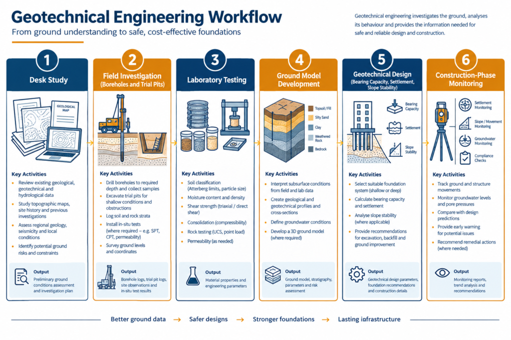
Geotechnical engineering works by investigating the ground through boreholes, trial pits, and in-situ testing, then sending samples to a laboratory to measure strength, compressibility, and permeability. Engineers use these results to calculate bearing capacity, settlement, and slope stability, then translate the findings into a foundation type, retaining structure design, and construction method statement.
What Geotechnical Engineering Actually Involves
Geotechnical engineering is the branch of civil engineering concerned with how soil and rock behave under load, and how that behaviour governs the design of foundations, retaining structures, slopes, and earthworks. Structural engineers design what a building or bridge is made of. Geotechnical engineers determine what it can safely stand on, and how the ground will move once it carries that load.
The discipline sits between geology and structural design. A geologist describes what the ground is made of and how it formed. A geotechnical engineer takes that description and turns it into numbers a structural designer can use: bearing capacity in kilonewtons per square metre, expected settlement in millimetres, a factor of safety against slope failure. Without that translation, a geological description is interesting but not buildable.
Every geotechnical assignment answers three linked questions. Can the ground carry the proposed loads without shearing? How much will it settle, and will that settlement be even or differential? And will the ground stay stable during construction — through excavation, dewatering, and temporary loading — as well as over the structure’s design life? A car park slab, a twenty-storey tower, and a highway embankment ask the same three questions; they just demand different depths of investigation to answer them.
The scope of work typically covers four areas: foundation design (spread footings, rafts, piles), retaining structures (sheet piling, diaphragm walls, gravity walls), slope and embankment stability, and ground improvement where the natural ground cannot carry the design loads without treatment — vibro stone columns, dynamic compaction, or preloading with vertical drains, for example. For a fuller walkthrough of the discipline’s scope, see StruviaCore’s definition of geotechnical engineering, which goes beyond this article’s process focus.
What separates a well-run geotechnical assignment from a rushed one is rarely the equipment. It comes down to how closely the investigation matches the ground conditions and the sensitivity of the structure. A single-storey warehouse on known competent sand needs less investigation than a twelve-storey tower on variable alluvial clay, even though both look like “just a foundation” from a client’s perspective.
How Ground Investigation and Testing Work
The technical core of the discipline happens in three stages: finding out what is already known, gathering new data from the ground itself, and converting that data into design parameters. Skipping or compressing any of the three stages is the single biggest driver of geotechnical claims on construction contracts.
Desk Study and Site Walkover
Before a single borehole goes in, an experienced geotechnical engineer builds a picture from existing information: historical mapping, published geological survey data, previous site investigation reports for the area, aerial photography showing filled ground or old quarries, and utility records. In Lagos and the Niger Delta, this stage routinely flags former wetland or reclaimed land that behaves very differently from the surrounding natural ground. In the UK, it commonly surfaces mining history, made ground, or contamination left over from a site’s industrial past. A walkover survey follows: the engineer checks for cracking in neighbouring structures, standing water, retaining walls under visible stress, and vegetation that hints at shallow groundwater.
Field Investigation Methods
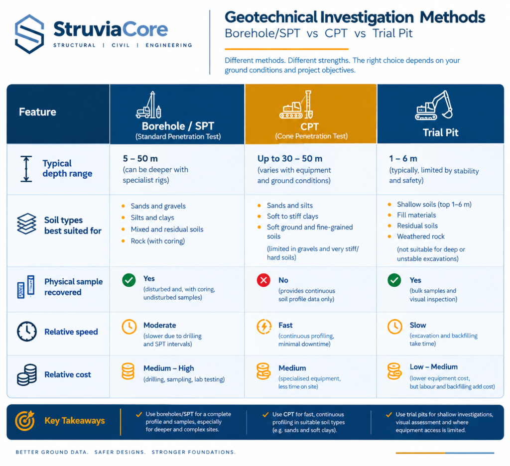
Boreholes — drilled by cable percussion or rotary methods — allow soil and rock sampling at depth and remain the primary tool for anything beyond shallow foundations. Trial pits, excavated by machine to two or three metres, let an engineer inspect and log the ground visually, and cost less than boreholes for shallow residential or light commercial work. The Standard Penetration Test (SPT), run inside a borehole at regular depth intervals, measures the blow count needed to drive a sampler 300mm and correlates directly to relative density and undrained shear strength. The Cone Penetration Test (CPT) pushes an instrumented cone continuously into the ground, producing a near-continuous profile of tip resistance and sleeve friction that is faster and more repeatable than SPT in soft to firm soils, though it recovers no physical sample. Piezometers installed in boreholes track groundwater level over weeks or months rather than relying on a single reading — a detail that matters where the water table fluctuates seasonally, as it does across the Niger Delta and coastal UAE.
Laboratory Testing and Building the Ground Model
Samples recovered from the field go to a laboratory for testing that field methods cannot replicate. Index tests — particle size distribution and Atterberg limits — classify the soil and flag shrink-swell potential, relevant wherever London Clay or similar plastic clays turn up. Triaxial tests (unconsolidated-undrained, consolidated-undrained, or consolidated-drained, depending on what the design needs to know) measure shear strength under controlled stress conditions. Oedometer tests measure compressibility and predict long-term consolidation settlement, which matters most on soft alluvial or lagoon clays where settlement can continue for years after construction finishes. Permeability testing informs dewatering design and drainage. Chemical testing for sulfate and chloride content sets the concrete class and cover needed to protect buried structures — a test that carries particular weight in the UAE, where saline groundwater and gypsiferous ground attack conventional concrete far faster than designers used to temperate climates expect.
Engineers combine all of this into a ground model: a simplified, layered representation of the subsurface with a characteristic value assigned to each parameter for each stratum. Eurocode 7 (BS EN 1997-1) sets out how engineers derive that characteristic value — a cautious estimate, not a simple average, chosen so the actual value governing failure is unlikely to be worse. This is also where the process connects directly to what happens next: once the ground model exists, it drives how the foundation design process selects and sizes a foundation type.
Regional Practice: Codes and Ground Conditions Across the UK, UAE, and Nigeria
Geotechnical engineering does not work identically everywhere, because the ground and the regulatory framework both change by geography. The physics of soil mechanics stays constant; the codes, the typical ground conditions, and the risks an investigation needs to rule out do not.
United Kingdom
BS 5930:2015 sets the code of practice for ground investigation, and geotechnical design itself runs under Eurocode 7 (BS EN 1997-1 and BS EN 1997-2), which replaced BS 8004 as the primary design code, though BS 8004 still gets referenced informally on smaller projects. Common conditions include the shrink-swell behaviour of London Clay and similar plastic clays — a major driver of subsidence claims on shallow foundations near trees — glacial till with strength that varies sharply over short distances, and Made Ground on former industrial sites, which routinely triggers a combined geotechnical and geo-environmental investigation. NHBC guidance adds foundation depth requirements specific to shrinkable clays and tree proximity for residential work.
United Arab Emirates
Dubai Municipality and Abu Dhabi’s regulatory bodies largely reference British and Eurocode standards with local amendments, so a UK-trained engineer recognises the design framework quickly. What differs is the ground. Coastal sites frequently sit on sabkha — a saline, sometimes collapsible deposit that can lose strength dramatically when it gets wet — over calcareous or carbonate sands with cementation that varies sharply over short distances. Groundwater often sits within a few metres of the surface and carries aggressive sulfate and chloride concentrations that attack conventional concrete, which is why chemical testing and sulfate-resisting cement specifications carry more design weight here than in temperate markets. The RTA sets additional geotechnical requirements for transport infrastructure.
Nigeria
COREN (the Council for Regulation of Engineering in Nigeria) regulates who may practise, and Nigerian geotechnical practice has historically drawn on British codes — BS 8004 and BS 5930 remain widely referenced on site, alongside relevant NIS standards, with Eurocode 7 adoption growing on larger and internationally funded projects. Ground conditions vary sharply by region: lateritic residual soils dominate much of the country and generally provide reasonable bearing capacity once stripped of topsoil, while Lagos and the wider Niger Delta sit on soft, compressible alluvial and lagoon clays that frequently push foundation design toward piling even for modest structures. Seasonal water table fluctuation complicates excavation and dewatering timing across the coastal belt, and investigation programmes here need to plan around the rainy season rather than assume UK-style year-round access.
These regional differences are why project teams treat every ground investigation as market-specific rather than copying a scope of work from one country to another — StruviaCore’s complete geotechnical engineering guide covers how investigation scope should scale with project type and ground risk in more depth.
Common Geotechnical Engineering Challenges and Cost Drivers
Most geotechnical disputes trace back to one of a small number of recurring problems, and nearly all of them cost less to prevent than to fix once construction has started.
Under-scoped investigation causes the most trouble. A borehole spacing chosen to save cost on a variable site — alluvial clay with lenses of sand and peat, for example — leaves gaps that the design has to bridge with assumption rather than data. When construction exposes ground that does not match the assumption, the result is a variation order, a programme delay, and often a dispute over who bore the risk. BS 5930 gives spacing guidance precisely to reduce this exposure, but guidance only helps when the investigation follows it.
Groundwater drives cost in almost every market this article covers, just in different ways. In the UAE, high saline groundwater near the coast means dewatering, temporary works design, and durability provisions all have to account for it from day one. In the Niger Delta and much of coastal Nigeria, seasonal water table rise can shut down excavation entirely for weeks if the programme was not built around the rainy season. In the UK, groundwater control on deep basements in London Clay is a specialist cost line that catches inexperienced estimators off guard.
Contaminated and variable made ground on brownfield or previously developed sites adds geo-environmental testing, waste classification, and sometimes remediation to what looks on paper like a straightforward foundation job. And heterogeneous ground — natural variability between one borehole and the next — forces a choice between a more conservative, more expensive design or additional investigation to narrow the uncertainty; on sensitive structures, the additional investigation is almost always the cheaper option over the life of the project.
The pattern across all of these: problems found before design cost money to investigate. Problems found during construction cost money to investigate, redesign, and delay — the full breakdown of these geotechnical engineering challenges covers mitigation strategies for each in more depth.
Best Practices for Getting Geotechnical Engineering Right
The difference between a geotechnical programme that protects a project and one that becomes a liability usually comes down to timing and scope rather than exotic technique. If you are commissioning or managing a ground investigation, these practices consistently separate the projects that stay on budget from the ones that do not:
- Commission the investigation early. Start before the concept design is frozen, not after, so the ground data can actually influence foundation type and layout instead of just confirming a decision that is already locked in.
- Match investigation scope to ground variability, not just site area. A uniform sand site and a site with interbedded clay, sand, and peat lenses need different borehole spacing even at the same footprint — use BS 5930’s guidance as a starting point, then adjust for what the desk study already tells you about local variability.
- Combine methods rather than relying on one. Pairing CPT’s continuous profile with SPT and borehole sampling at key locations gives you both the detail and the physical samples that CPT alone cannot recover.
- Test to a depth that covers the zone of influence below the founding level, not just to the founding level itself — settlement calculations need data from where the load actually affects the ground, which for a piled foundation can be many metres below pile toe.
- Specify chemical testing early on aggressive ground. Sulfate and chloride results affect concrete mix design and cover, and finding out late forces a redesign that a week of lab time would have avoided.
- Keep the geotechnical designer engaged through construction. The observational method — checking exposed ground against the design assumption and adjusting if it does not match — only works if the person who made the assumption is still on the project when the excavation opens up.
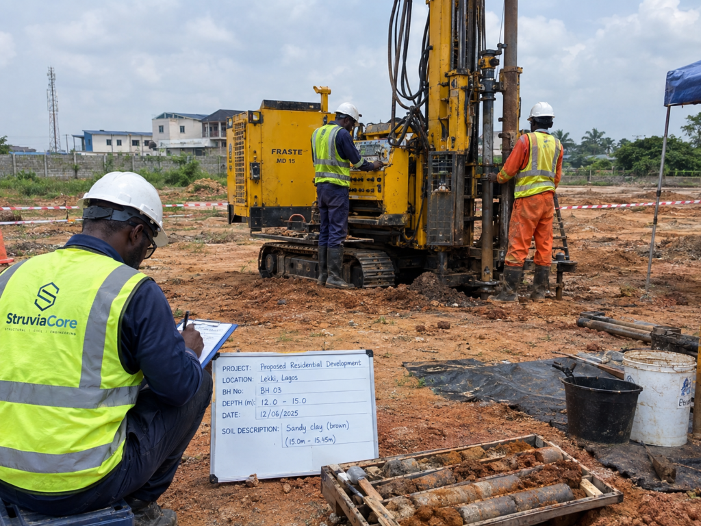
None of this requires unusual equipment or specialist software most consultancies do not already have. It requires treating the ground investigation as a design input with its own lead time, rather than a box to check between land acquisition and planning submission. StruviaCore’s geotechnical engineering best practices guide expands this into a fuller project checklist, including sign-off stages and typical lead times by project scale.
Frequently Asked Questions About Geotechnical Engineering
Q: What is geotechnical engineering in civil engineering?
A: Geotechnical engineering is the branch of civil engineering that studies how soil and rock behave under load and uses that understanding to design foundations, retaining structures, slopes, and earthworks. It sits between geology, which describes the ground, and structural engineering, which designs what sits on top of it. In the UK, UAE, and Nigeria alike, it is the discipline responsible for confirming that a given site can safely carry a proposed structure.
Q: How does geotechnical engineering work on a typical project?
A: It starts with a desk study of existing records, followed by field investigation using boreholes, trial pits, and in-situ tests such as SPT or CPT. Samples go to a laboratory for strength, compressibility, and chemical testing, and engineers combine the results into a ground model with characteristic design parameters set under Eurocode 7. Structural and geotechnical designers then use that model to select and size foundations, retaining structures, and any ground improvement the site requires.
Q: What are the geotechnical investigation requirements before foundation design?
A: BS 5930 recommends borehole depth and spacing based on structure type, loading, and ground variability rather than a single fixed rule, but a common starting point for a multi-storey building is boreholes to at least 1.5 times the width of the loaded area below founding level, or deeper where compressible strata are suspected. Requirements tighten further where piling, deep basements, or known problem ground such as sabkha or soft alluvial clay are involved. A geotechnical engineer should confirm scope against the specific site rather than apply a generic minimum.
Q: How much does a geotechnical investigation cost?
A: Cost depends on site size, ground variability, and how many boreholes or trial pits the investigation needs, so contractors usually see it priced as a project-specific quotation rather than a fixed fee. As a rough guide, site investigation is typically a small percentage of overall construction value on straightforward sites, rising well beyond that on constrained urban plots, contaminated land, or sites needing specialist testing such as chemical analysis for aggressive groundwater. Treating this as a cost to minimise rather than a design input sized to the site is the most common way projects overspend later, once unforeseen ground conditions surface during construction.
Q: What is the difference between geotechnical engineering and geology?
A: Geology describes what the ground is made of and how it formed, using qualitative and descriptive terms. Geotechnical engineering takes that description and adds quantitative parameters — shear strength, compressibility, permeability, characteristic values under Eurocode 7 — that a structural designer can actually calculate with. A geologist can tell you a site sits on alluvial clay; a geotechnical engineer tells you what bearing pressure that clay can safely carry and how much it will settle under a specific load.
Geotechnical engineering works by turning an unknown — what is actually in the ground — into numbers a design team can build on: bearing capacity, settlement, slope stability, and the groundwater and chemical conditions that affect durability. That translation happens through desk study, field investigation, laboratory testing, and a ground model built on Eurocode 7 principles, then stays relevant through construction via monitoring and the observational method. Skipping stages to save time on the front end is consistently where projects lose the most time and money on the back end, whether the site sits on London Clay, Dubai sabkha, or Lagos lagoon clay. If your project needs a ground investigation scoped correctly the first time, StruviaCore’s geotechnical team works across UK, UAE, and Nigerian sites and can help you plan the investigation before your design programme locks it in.
Leave a Reply