

A civil engineer submitting a residential layout for approval in Lekki, Lagos, finds that the site sits inside a floodplain the 2015 zoning map never flagged. The stormwater drain downstream was sized for half of today’s built density, and every extra square metre of paved surface pushes runoff past its design capacity. This is not a foundation problem — it is a failure of urban planning, the discipline that decides where buildings, roads, and utilities go before a single beam gets specified. This urban planning guide sets out how that discipline works for civil and structural engineers: how land-use decisions get made, what data drives a master plan, how approval differs between Nigeria, the UK, and the UAE, and where you fit into a process planners often treat as their own.
Urban Planning: Quick Answer
Urban planning is the process of allocating land use, density, and infrastructure capacity across a city or district to guide its development. It combines zoning regulation, master planning, and infrastructure sequencing. For engineers, it fixes design constraints — site access, utility loading, flood risk, and permitted density — before structural design begins.
What Urban Planning Means for Civil and Structural Engineers
Urban planning is the allocation of land use, density, and infrastructure capacity across a defined area, structured through zoning codes, master plans, and development control regulations. A planner draws the boundaries of what can be built where; an engineer works out how it gets built within those boundaries. The two roles sit on the same project but answer to different constraints — a planner is bound by policy documents and public consultation, while an engineer is bound by loading codes, ground conditions, and utility capacity. Neither can do the job alone. A master plan that ignores subsoil conditions produces sites that cannot carry the density it assigns them. A structural design that ignores the zoning envelope produces a building that never gets a permit.
In Lagos, this relationship runs through the Lagos State Physical Planning Permit Authority (LASPPPA) and the Lagos State Urban and Regional Planning and Development Law. A development permit references the applicable district plan, and any variance — extra storeys, a different land use, a reduced setback — triggers a separate approval track that can add months to a programme. COREN-registered engineers submitting structural drawings for permit are expected to reference the approved layout, not a preliminary sketch, because the permitted footprint determines allowable floor loading and, in flood-prone districts, minimum finished floor levels.
Land-Use Zoning and Density Frameworks
Zoning assigns each parcel a permitted use — residential, commercial, industrial, mixed-use — and a density envelope expressed as plot ratio, floor area ratio (FAR), or maximum storeys. A FAR of 3.0 on a 1,000 m² plot permits 3,000 m² of gross floor area, distributed across whatever height and footprint the local building line and setback rules allow. Density drives everything downstream of it: parking provision, utility connection sizing, and the live loads your structural design has to carry. Get the zoning read wrong at concept stage and you redesign the frame later, not the paperwork.
The Engineer’s Role Versus the Planner’s Role
A planner sets what is permitted; an engineer confirms what is buildable. On a mixed-use scheme in Abuja’s Central Business District, for instance, the master plan might assign a plot for a 12-storey tower, but a geotechnical investigation showing shallow bearing capacity below 4 bar could force a piled foundation solution that changes the project’s cost basis entirely. That finding does not overturn the zoning — it changes how the engineer meets it. Read our smart cities framework for how these planning and engineering functions integrate at city scale, particularly where sensor networks and utility metering now feed directly into zoning and infrastructure decisions.
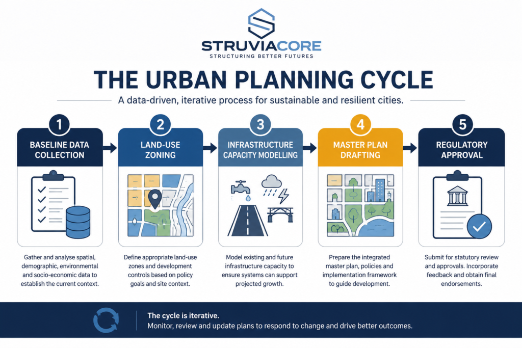
The Urban Planning Process: Data, Modelling, and Master Plans
A credible master plan starts with baseline data, not a concept sketch. Planning teams collect topographic surveys, geotechnical borehole logs, hydrological catchment data, existing utility as-built drawings, traffic counts, and population growth projections before a single land-use boundary gets drawn. Skipping this stage is how districts end up with drainage systems sized for yesterday’s density, a problem repeated across fast-growing Nigerian and Gulf cities where informal development has outpaced formal planning cycles by a decade or more in some corridors.
Site Investigation and Baseline Data Collection
Geotechnical data shapes zoning as much as market demand does. A district with shallow water tables and soft alluvial soils, common along the Lagos lagoon fringe, cannot sustainably carry the same tower density as firmer ground further inland, regardless of what a demand study recommends. Our geotechnical engineering guide covers the borehole spacing and standard penetration test intervals typically specified for master-plan-level site investigation, ahead of any individual building’s own geotechnical report.
Infrastructure Capacity Modelling
Water demand, wastewater generation, power load, and road capacity all get modelled against the proposed density before it is confirmed, not after. A district planned for 40,000 residents needs its trunk infrastructure sized against that ceiling from day one, because retrofitting a sewer trunk main under a fully built-up corridor costs several times what it costs to size it correctly at the master-plan stage. Engineers reviewing infrastructure capacity studies should confirm the growth horizon used — a 10-year design horizon produces a materially different pipe diameter than a 25-year one, and Nigerian utility providers frequently work to shorter horizons than their UK or UAE counterparts because of funding cycles rather than technical preference.
Master Plan Development and Structure Plans
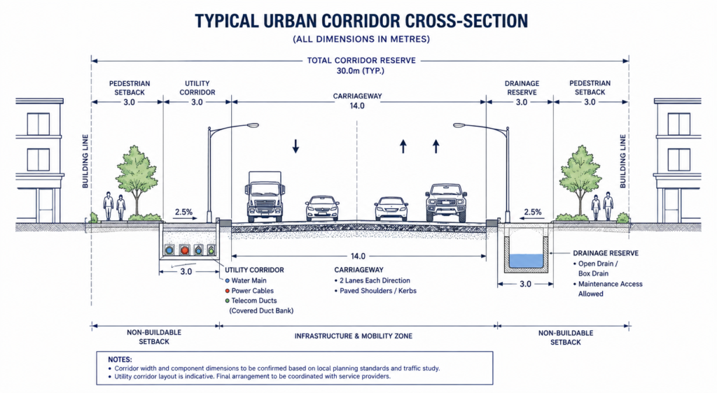
The master plan translates the data into a physical layout: road hierarchy, land-use zones, open space allocation, and infrastructure corridors. A structure plan sits above it, setting broader policy direction over a longer horizon, typically 15 to 25 years, within which individual master plans and local area plans get prepared. Abuja’s original 1979 master plan by International Planning Associates remains the reference structure plan for the Federal Capital Territory, and most Abuja development applications still get checked against it, decades on, for consistency with the district layout it established.
Public consultation runs alongside the technical work in all three markets, though the formal mechanism differs. UK Local Plans go through statutory Regulation 19 consultation before adoption, with objections capable of triggering an independent examination that can delay adoption by a year or more. Nigerian state planning laws typically require public display of a draft layout rather than a formal hearing process, and Gulf master plans tend to run consultation through appointed stakeholder committees rather than open public comment. An engineer joining a project after a master plan has been adopted should still check whether any unresolved consultation objection is attached to the specific site, since a standing objection can resurface at the individual building permit stage even after the wider plan is approved.
Regulatory Frameworks Across Nigeria, UK, and UAE Markets
Approval structures differ enough between these three markets that an engineer working across them cannot assume one process transfers to another. In Nigeria, development control sits primarily with state-level authorities — LASPPPA in Lagos, the Federal Capital Development Authority (FCDA) in Abuja — operating under state planning laws rather than a single national code. Permit timelines vary widely by state, and informal settlement regularisation remains a live planning issue in most major cities, with implications for utility connection legality that engineers need to flag during due diligence.
The UK works through the Town and Country Planning Act 1990 and the National Planning Policy Framework (NPPF), administered by local planning authorities against adopted Local Plans. A Section 106 agreement often attaches infrastructure obligations — a new junction, a school contribution, affordable housing quotas — directly to a planning permission, and engineers pricing a scheme need those obligations quantified before tender, not discovered at the S106 negotiation stage. The Royal Town Planning Institute (RTPI) sets professional standards for chartered planners, parallel to how COREN regulates engineers in Nigeria.
The UAE runs a more centralised model. Dubai Municipality administers development control against the Dubai 2040 Urban Master Plan, which sets population and land-use targets across five defined urban centres. Abu Dhabi’s Department of Municipalities and Transport (DMT) applies the Estidama Pearl Rating System, mandating a minimum one-Pearl rating on all new buildings and higher ratings for government-funded projects, which folds sustainability compliance directly into the planning approval rather than treating it as a separate certification. Engineers used to Nigeria’s more discretionary, case-by-case approval process often underestimate how prescriptive Estidama’s design-stage documentation requirements are by comparison.
ISO 37120 and ISO 37122, covering sustainable and smart city indicators respectively, increasingly show up as reference frameworks in tender documents across all three markets, particularly where a project claims smart-city or connected-infrastructure credentials. Our connected infrastructure guide covers how these indicator sets translate into specific sensor and monitoring requirements at design stage.
How Digital Tools Are Changing Urban Planning Practice
Planning authorities across all three markets have moved a meaningful share of the approval process online, and the shift changes what an engineer needs to prepare before submission. LASPPPA’s e-planning portal now processes layout and building permit applications digitally in Lagos, which shortens the administrative turnaround on straightforward applications but does not shorten the technical review — a structural submission still needs the same supporting calculations and drawings a paper file required, formatted for digital upload rather than physical binding.
Dubai’s approach goes further. The Dubai 2040 Urban Master Plan is maintained alongside a citywide digital twin that Dubai Municipality uses to model infrastructure capacity, traffic flow, and utility demand against proposed developments before they reach the approval stage. A developer proposing additional density in an urban centre can, in principle, have that proposal tested against the digital twin’s current infrastructure model rather than waiting for a manual capacity study, which changes the sequence of information an engineer needs to have ready at pre-application stage. Abu Dhabi’s DMT runs a comparable geographic information system (GIS) layer beneath its Estidama approval process, cross-referencing plot-level sustainability data against the wider master plan.
The UK’s planning reform agenda, set out through successive updates to the NPPF, has pushed local planning authorities toward digital Local Plans with machine-readable zoning data, intended to let a site’s constraints — flood zone, conservation area, density allowance — be queried automatically rather than read off a paper map. Coverage remains uneven between authorities, so an engineer should confirm whether a given local authority’s digital layer is authoritative or advisory before relying on it in place of a written planning history search.
None of these tools remove the underlying verification work — they change where the burden of proof sits. A digital twin or GIS layer is only as current as its last data update, and engineers have found capacity models running twelve to eighteen months behind actual site conditions in fast-changing corridors. Treat a digital planning tool’s output as a starting reference for your own due diligence, not a substitute for the utility capacity letter or geotechnical investigation covered earlier in this guide. Our urban infrastructure guide covers how these digital capacity models connect to the physical utility networks engineers ultimately design against.
Common Challenges and Cost Factors in Urban Planning Projects
Three recurring problems account for most of the cost overruns engineers encounter on urban planning-linked projects. The first is outdated baseline data: a master plan built on a five-year-old traffic count or an aerial survey predating a major access road change produces infrastructure sizing that is wrong before construction even starts. Verify the survey date on any master plan document you are designing against, and flag a re-survey where the underlying data is more than three years old in a fast-growing corridor.
The second is misalignment between the approved land-use zone and the utility capacity actually available on site. A plot zoned for high-density residential use next to a transformer substation with no spare capacity looks buildable on the master plan but is not connectable without a substation upgrade that can add six to eighteen months and a significant unbudgeted cost to a Nigerian urban project, depending on the distribution company’s upgrade queue. Confirm connection capacity with the utility provider directly, in writing, before committing a design to a specific density.
The third is variance and change-of-use applications, which move a project off its baseline approval timeline. Every additional storey, land-use change, or setback reduction beyond what the original permit covers restarts part of the review process, and in Lagos this can mean a fresh LASPPPA submission cycle rather than an amendment to the existing file. Budget contingency time for at least one variance cycle on any scheme where the client’s brief has changed since the original zoning application, because it almost always has by the time detailed design starts.
Cost factors compound across these three issues rather than adding linearly. A project with outdated baseline data and a utility capacity shortfall does not just face two separate delays — the utility upgrade design itself depends on corrected demand figures from the re-survey, so the two workstreams queue rather than run in parallel. Build that dependency into your programme rather than assuming concurrent working, and price the float accordingly.
UK and UAE schemes carry a different version of the same risk. A Section 106 obligation discovered late in a UK programme can add a fixed infrastructure contribution that was never priced into the original tender, while an Estidama Pearl rating shortfall found at design review in Abu Dhabi can force a late specification change to building envelope or water fixtures to recover the required rating. Both are avoidable with the same discipline that avoids the Nigerian utility capacity problem: confirm the specific obligation or rating target attached to your site before pricing the scheme, rather than working from the general policy document alone.
Best Practices for Engineers Working Within an Urban Planning Framework
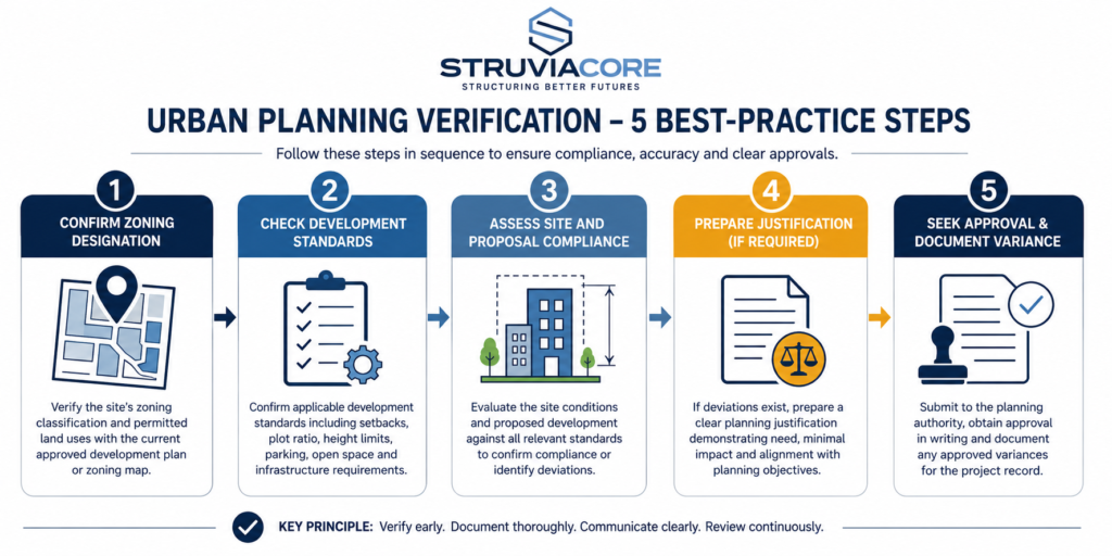
You reduce planning-related risk on a project by treating the zoning and master plan as design inputs to verify, not assumptions to accept. The following sequence reflects how experienced structural and civil teams handle projects sitting inside an active master plan, whether in Lagos, London, or Dubai.
- Confirm the applicable zoning instrument by name and date before starting concept design — a district’s zoning can be superseded by a newer local area plan without the change being obvious from a site visit alone.
- Request utility capacity letters early from water, power, and drainage providers, rather than relying on the master plan’s stated infrastructure allocation, which reflects planned capacity, not confirmed current capacity.
- Commission an independent geotechnical investigation at your specific plot even where a district-level ground investigation exists — district data tells you what to expect, not what your foundation design can rely on.
- Cross-check flood risk against current hydrological data, particularly in coastal and riverine Nigerian markets, since catchment conditions upstream can change faster than flood maps get revised.
- Document every variance from the base zoning in writing with the approving authority before proceeding to detailed design, so structural loading assumptions do not get finalised against a permit that has not actually been granted.
Sequencing matters as much as the individual checks. Run the geotechnical and utility capacity verification in parallel with concept design rather than after it, because a capacity shortfall discovered at detailed design stage forces rework that a two-week verification exercise at concept stage would have avoided entirely. Our urban mobility guide sets out a comparable verification sequence for transport-linked infrastructure, where road capacity and access design carry similar early-stage risk.
Assign ownership of each verification step to a named team member rather than treating the checklist as a shared responsibility, because shared ownership is how a utility capacity letter quietly slips from “requested” to “assumed received” over the course of a busy programme. On multi-market schemes, keep a single register tracking which checks have been completed against which regulatory framework — a verification step satisfied under LASPPPA’s requirements does not automatically satisfy Estidama’s documentation standard on a comparable Gulf project, even where the underlying engineering content overlaps.
Frequently Asked Questions About Urban Planning
Q: What is urban planning in civil engineering?
A: In civil engineering terms, urban planning is the process that assigns land use, permitted density, and infrastructure capacity across a district before individual buildings get designed. It determines a site’s zoning envelope, access requirements, and utility loading, which then become fixed inputs for structural and civil design rather than variables the engineer can adjust.
Q: How does the urban planning approval process work in Nigeria?
A: Approval runs through state-level authorities — LASPPPA in Lagos, FCDA in Abuja — rather than a single national planning code. An applicant submits layout and building plans referencing the approved district plan, and COREN-registered engineers typically handle the structural submission alongside the architect’s planning application. Timelines vary by state and by whether the application requires a variance from the base zoning.
Q: What is the difference between a master plan and a structure plan?
A: A structure plan sets broad policy direction for an area over a long horizon, typically 15 to 25 years, covering land-use principles without site-specific detail. A master plan sits below it and translates that direction into a physical layout — specific zoning boundaries, road alignments, and infrastructure corridors — usually for a district or new development area within a shorter delivery timeframe.
Q: How much does an urban planning-related permit delay typically cost a project?
A: Costs vary by market and project scale, but a single variance cycle in Lagos commonly adds several weeks to a few months to a programme, and a utility capacity shortfall requiring a substation or feeder upgrade can add six to eighteen months in areas with constrained distribution capacity. Engineers should price float for at least one review cycle on any scheme with a non-standard density or land-use request.
Q: What are the main urban planning requirements engineers need to check before design?
A: Confirm the applicable zoning instrument and its date, the permitted density (plot ratio or FAR), current utility capacity in writing from the provider, flood risk against up-to-date hydrological data, and any outstanding variance requirements. Each of these can change independently of the others, so checking the master plan alone is not sufficient.
An urban planning guide is only useful to an engineer if it changes what gets checked before design starts, not just what gets read afterward. Zoning, density, and infrastructure capacity are design inputs with the same weight as a geotechnical report or a loading code — treat them as fixed only after you have verified them against current data, not the master plan’s original assumptions. That verification step, run early and in writing, is what separates a scheme that clears approval on schedule from one that spends its programme absorbing planning risk it could have priced at concept stage. If your team needs support verifying zoning, infrastructure capacity, or geotechnical conditions against a live master plan, StruviaCore’s engineering teams work across Nigerian, UK, and Gulf planning frameworks and can review your site-specific risk before you commit to a design.
Leave a Reply