
Every civil engineer eventually stands at a site where the drainage cannot handle the rain that actually falls — a culvert sized for a smaller catchment now serving three times the paved area, or a borehole yielding less water each dry season as the surrounding aquifer draws down. These are water resources problems, and they sit at the centre of nearly every infrastructure decision, whether you are laying out a housing estate outside Lagos, sizing a stormwater network in Dubai, or checking a reservoir spillway in the English Midlands. Water resources is the branch of civil engineering that plans, designs and manages how water moves through, is stored by, and is delivered across the built and natural environment — supply, drainage, flood control, irrigation and wastewater collection all sit inside its scope. This article sets out what the discipline actually covers, the design methods and standards that govern it in Nigeria, the UK and the UAE, and the judgement calls that separate a scheme that survives its first major storm from one that fails at the first test. It also sets out where the discipline stops and neighbouring fields, particularly hydraulic and geotechnical engineering, pick up the work.
Water Resources: Quick Answer
Water resources engineering is the discipline that plans, designs and manages water supply, drainage, flood control and disposal systems for a catchment or community. It draws on hydrology, hydraulics and geotechnical data to size reservoirs, sewers, drainage networks and treatment works to standards such as BS EN 752 and BS EN 1992-3.

What This Discipline Actually Covers
Water resources engineering sits at basin or catchment scale, above the individual structure. A structural engineer designs a specific tank or culvert; an engineer working in this field first works out how much water a catchment produces, how much a population or industry needs, and how the two figures should be balanced over time. That balance drives everything downstream: the size of a treatment works, the capacity of a distribution network, the height of a flood embankment, and the yield a state agency can promise a new estate before construction even starts. Get that balance wrong at the planning stage and no amount of downstream hydraulic or structural refinement fixes it — the scheme is undersized or oversized before a single pipe is ordered.
Scope of Practice
In practice, the discipline covers eight overlapping areas, and framing a brief around them helps you scope a project correctly from day one:
- Water supply planning, treatment and distribution
- Stormwater and urban drainage design
- Flood risk assessment and flood defence
- Irrigation and agricultural water management
- Groundwater investigation and aquifer management
- Wastewater collection and treatment planning
- Dam, weir and reservoir engineering
- River and coastal engineering
A single project rarely touches all eight. A housing estate mostly needs supply and drainage; a hydropower scheme needs dam design, reservoir operation rules and downstream flow management. A working grasp of all eight still matters, because a decision made in one area routinely creates a problem in another — over-abstracting a river for irrigation, for instance, can undercut the yield promised to a downstream treatment works, and an undersized flood embankment upstream can turn a manageable storm into a washed-out access road for an otherwise well-designed estate.
How This Discipline Differs From Hydraulic Engineering
The two disciplines are often confused, and for good reason: they overlap constantly on the same drawings. Hydraulic engineering concerns the behaviour of water in motion — pipe flow, open-channel flow, pump curves, and the forces water exerts on a structure. Water resources engineering sits one level up: it decides how much water is available, how much is needed, where it should go, and under what regulatory and environmental constraints. A catchment study establishes that a river can safely support an abstraction of a given volume per day; hydraulic engineering then sizes the intake structure, the pipeline and the pumping station that deliver it. Neither discipline works well alone — a hydraulically elegant pipe network is worthless if the underlying catchment study overestimated the source’s yield, and a generous yield estimate is worthless if the intake structure sized against it cannot physically pass the design flow.
Core Design Methods and Processes
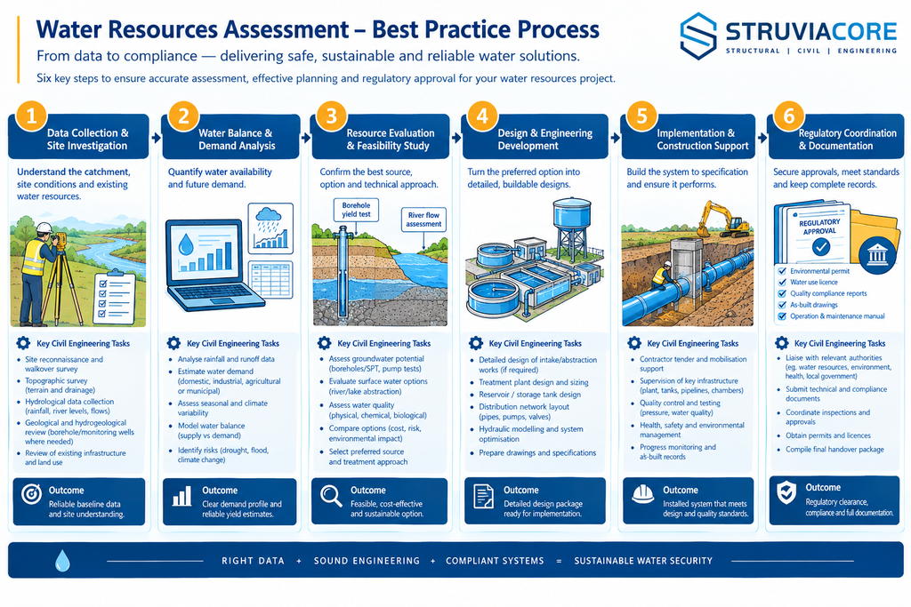
A typical design process for these systems runs through four stages: data collection, hydrological analysis, hydraulic sizing, and demand or distribution design. Skipping the first stage is the most common cause of an undersized scheme, because every downstream calculation inherits the error. Each stage also has a natural checkpoint where a second engineer should review the assumptions before the design moves on, since an error caught at the hydrology stage costs a redraft; the same error caught after construction costs a retrofit.
Hydrological Analysis and Rainfall-Runoff Modelling
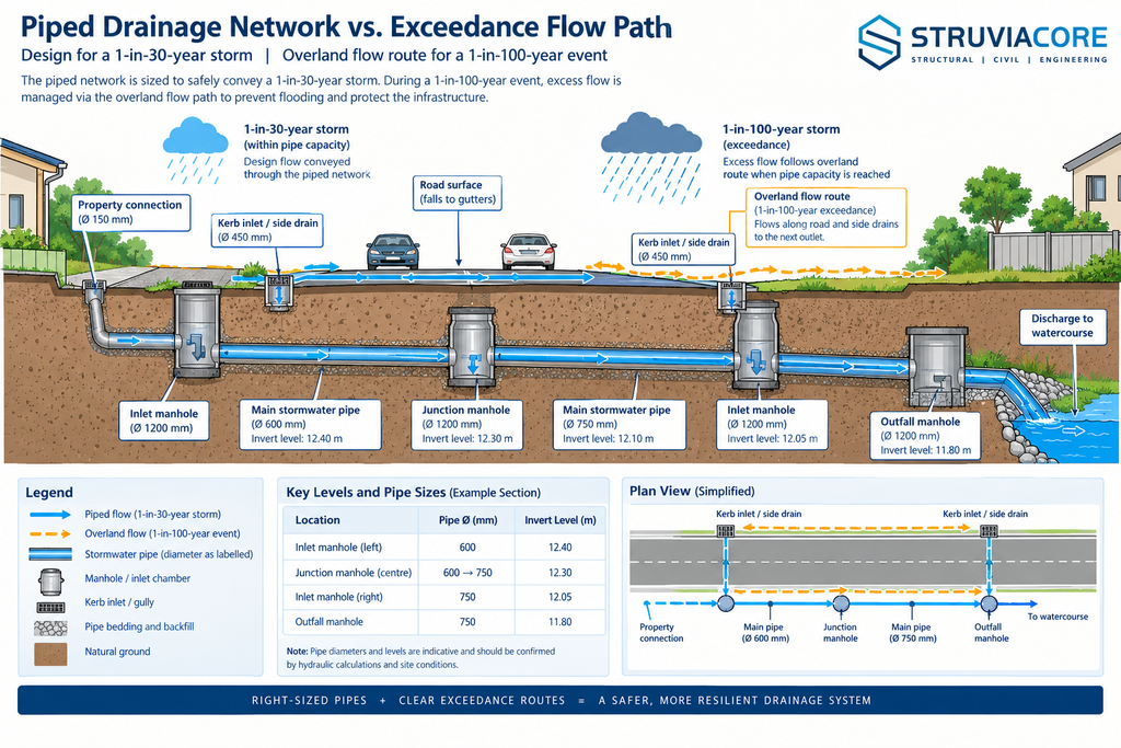
Design starts with data: rainfall records ideally spanning 20 to 30 years, river gauge readings where available, soil infiltration characteristics, and a catchment delineation showing area, slope and land use. For small, well-defined catchments, engineers commonly apply the Rational Method (Q = CiA, adjusted for units), where C is a runoff coefficient reflecting surface type, i is rainfall intensity taken from local intensity-duration-frequency data, and A is catchment area. Larger or ungauged catchments call for more detailed approaches — the SCS Curve Number method or, in the UK, the methods set out in the Flood Estimation Handbook. Return period selection follows local practice rather than a single global rule: UK piped drainage is typically sized to a 1-in-30-year storm (3.33% annual exceedance probability) with exceedance flow paths checked against a 1-in-100-year event, and BS EN 752:2017 recommends applying a climate change allowance of around 1.4 to design rainfall intensities. Dubai Municipality’s Stormwater Design Guidelines apply a comparable logic using storm profiles built specifically for the emirate’s arid rainfall pattern, rather than importing a temperate-climate curve. In much of Nigeria, by contrast, the limiting factor is rarely the design method itself — it is the rainfall and river-gauge record, which is often too short or too gappy to support anything beyond a conservative regional envelope curve.
Hydraulic Design of Conveyance and Storage Structures
Once the design flow is fixed, conveyance sizing follows established open-channel and pipe-flow theory. Manning’s equation sizes open channels and culverts; the Colebrook-White or Hazen-Williams relationships size pressurised pipe networks. Storage is sized against demand variation rather than peak flow alone — service reservoirs are commonly sized to hold 24 to 48 hours of average demand as an operational buffer against supply interruption. Pump stations are then selected to match the system curve at that storage volume, with duty and standby units specified so that a single pump failure does not take out supply to the served population. None of this sizing means much if the structure cannot stand where it is put: intake structures, weirs and pump station foundations need a proper geotechnical investigation before the hydraulic design is finalised, since bearing capacity, settlement and, for embankment dams, seepage behaviour through the foundation strata can override an otherwise sound hydraulic layout.
Water Demand Assessment and Distribution Network Design
Demand forecasting multiplies a population projection by a per capita consumption figure, and that figure varies sharply by market. Nigeria’s National Water Supply and Sanitation Policy sets an urban target of 120 litres per person per day, though independent surveys across several Nigerian towns and cities routinely record actual delivery well below that figure, which is precisely why so many new schemes are designed against the policy target rather than existing supply data. Dubai Municipality’s sewerage design criteria assume a sewage generation rate of around 280 litres per person per day, calculated as roughly 80% of the potable demand figure set by the Dubai Electricity and Water Authority. UK government data puts average personal consumption at around 140 litres per day, against a national target of 130 litres per day by 2040. Once a design demand is set, the distribution network is modelled as a pipe network — commonly in software such as EPANET — sized to maintain minimum residual pressure at the furthest and highest points under peak demand, with fire flow and future growth allowances added on top of the base residential figure rather than absorbed into it.
Regulatory Framework Across Nigeria, the UK and the UAE
Water resources projects sit under more regulatory oversight than most civil works, because a single scheme can affect river flow, groundwater levels, public health and flood risk for people who never see the drawings. The regulatory picture also differs sharply between the three markets StruviaCore works across most often, and treating one jurisdiction’s approach as a template for another is a reliable way to miss a mandatory approval step.
In Nigeria, the Federal Ministry of Water Resources and Sanitation, established in 1976, oversees twelve River Basin Development Authorities created under the River Basin Development Authorities Act to develop surface and groundwater resources, provide irrigation infrastructure, and manage flood and erosion control within their catchment areas. Drinking water quality is governed by NIS 554:2015, the Nigerian Standard for Drinking Water Quality, administered by the Standards Organisation of Nigeria in coordination with the Ministry and based substantially on WHO guideline values. Surface and groundwater discharge quality falls under NESREA’s National Environmental (Surface and Groundwater Quality Control) Regulations, and any engineer signing off a design in this field must be COREN-registered to practise legally. The National Water Resources Institute in Kaduna, established in 1979, remains the main training ground for the hydrologists and engineers who staff these agencies.
In the UK, the Flood and Water Management Act 2010 gave Lead Local Flood Authorities responsibility for local flood risk management and created a statutory expectation that new developments include sustainable drainage systems, designed to the principles in CIRIA’s SuDS Manual (C753). The Environment Agency regulates abstraction licensing and flood risk consultation, drain and sewer design outside buildings follows BS EN 752:2017, and liquid-retaining concrete structures such as service reservoirs and treatment tanks are now designed to BS EN 1992-3 (Eurocode 2, Part 3), which superseded the older BS 8007:1987. A scheme’s climate resilience is no longer optional in UK flood risk assessments — the Environment Agency’s climate change allowance guidance now sets specific percentage uplifts to peak rainfall and river flow depending on a development’s design life.
In the UAE, water resources planning answers a different physical reality: negligible natural surface water and limited renewable groundwater mean potable supply depends heavily on desalination, coordinated through DEWA in Dubai and the relevant federal and emirate-level authorities elsewhere. Dubai Municipality’s Stormwater and Sewerage Design Guidelines, revised in 2025, set the hydrological and hydraulic design criteria for new developments, while the Roads and Transport Authority co-designs drainage for any scheme that interfaces with a public road. Federal-level strategy adds a further layer, since national water security planning treats desalination capacity and demand management as two sides of the same balance sheet that a river basin plan elsewhere would treat as catchment supply and demand.
Common Challenges and Cost Factors in Practice
Three problems recur across almost every water resources brief, regardless of market, and each one has a direct cost consequence if it surfaces late rather than early.
The first is data scarcity. Rainfall and river-gauge records in many parts of Nigeria and other developing regions are short, gappy or simply unavailable at the site scale, which forces designers toward regional envelope curves or conservative assumptions that inflate structure sizes and cost. Commissioning new monitoring — a rain gauge, a stream gauge, a set of monitoring boreholes — takes months to produce a useful record, so it needs to start at project inception, not once design is already underway.
The second is the gap between design standards and delivered performance. A scheme designed against Nigeria’s 120 litre per person per day policy target still has to reckon with the reality that many existing networks deliver a fraction of that figure, meaning rehabilitation and demand management often deserve as much budget as new capacity. A distribution network is only as good as the treatment works feeding it and the network condition carrying the water onward, and undersizing either one wastes the investment in the other.
The third is urban infrastructure encroachment on drainage corridors and floodplains. Rapid, often informal urban growth in cities across Nigeria and other fast-growing markets steadily narrows natural drainage channels and floodplains, cutting the conveyance capacity a drainage master plan assumed at the time it was drawn up. Retrofitting capacity into an already-built environment costs several times what preserving the corridor would have cost, and it usually requires land acquisition, diversion of existing utilities, and temporary flood risk to residents during construction.
Cost itself is driven by a narrower set of factors than the challenges above might suggest. Imported pumps, valves and instrumentation carry currency exposure in markets like Nigeria, where naira depreciation against the dollar can move an equipment budget significantly between tender and delivery. Land acquisition and wayleave negotiation for pipeline and reservoir corridors regularly outlasts the design programme itself. Energy cost dominates the lifecycle budget for any scheme reliant on desalination or long-distance pumping, which is why UAE utilities size pumping and treatment capacity as much against future energy tariffs as against peak demand. Climate variability compounds all of this: rainfall intensity records compiled decades ago increasingly understate current storm behaviour, so a scheme designed strictly to historical statistics without a forward-looking allowance risks being undersized before it is even commissioned.
Best Practices for Project Delivery
Consistently sound projects in this field share a handful of habits regardless of market. Building them into your process from the brief stage costs little; retrofitting them after design is well underway costs a great deal more.
- Commission or source at least 20 years of rainfall and, where relevant, river flow data before finalising a catchment’s design hydrology.
- Ground-truth demand assumptions against actual metered consumption or comparable schemes, rather than relying solely on national per capita design standards.
- Sequence geotechnical investigation early enough that foundation conditions can still influence intake, weir or reservoir siting, not just their structural detailing.
- Apply the relevant national climate change allowance to design rainfall and river flow, and document the allowance used and its source.
- Check exceedance flow paths for major storm events even where the piped system itself is only sized to a minor storm return period.
- Coordinate drainage and supply design with the wider road, utility and land-use masterplan rather than as a standalone technical exercise.
You should also treat regulatory sign-off as a design input, not a final hurdle. Requesting early feedback from a River Basin Development Authority, an Environment Agency officer, or a Dubai Municipality reviewer — depending on jurisdiction — routinely surfaces constraints such as protected watercourses, planned trunk infrastructure or abstraction licence limits that are far cheaper to design around than to retrofit after a scheme has been fully detailed. Document every assumption behind a demand figure, a runoff coefficient or a climate change allowance in the design report; a colleague revisiting the scheme after ten years of catchment change needs to know why a number was chosen, not just what it was, since catchments and regulations both drift over a scheme’s operating life.
Frequently Asked Questions About Water Resources
Q: What is water resources engineering in civil engineering?
A: Water resources engineering is the civil engineering discipline responsible for planning, designing and managing how water is captured, stored, treated, distributed and discharged within a catchment or community. It sits above single-structure design, feeding output data such as available yield, demand and flood extents into hydraulic, structural and geotechnical designs. In Nigeria, a practising engineer in this field also needs a working knowledge of the River Basin Development Authorities Act and COREN registration requirements.
Q: What is the difference between water resources engineering and hydraulic engineering?
A: This discipline answers how much water is available, how much is needed, and where it should go, covering catchment hydrology, demand forecasting and allocation policy. Hydraulic engineering answers how the water actually moves once those decisions are made, covering pipe and channel flow, pump selection and structural hydraulic loading. Most real projects need both disciplines working together rather than one substituting for the other.
Q: What standards apply to water resources projects in Nigeria?
A: These projects operate under the River Basin Development Authorities Act of 1976, the National Water Supply and Sanitation Policy, and NIS 554:2015 for drinking water quality. Consulting engineers must register with COREN to practise legally, and surface and groundwater discharge quality falls under NESREA’s National Environmental (Surface and Groundwater Quality Control) Regulations.
Q: How much does a water resources feasibility study cost?
A: Cost depends heavily on catchment size, existing data quality, and whether new hydrological or geotechnical fieldwork is required. A desk-based water balance study for a single estate is a relatively contained exercise, while a full river basin master plan involving new hydrological modelling, borehole investigation and stakeholder consultation runs considerably higher. Data-poor catchments cost more up front because new rainfall, flow or groundwater monitoring has to be commissioned before design work can properly begin.
Q: What is the difference between water supply engineering and wastewater engineering?
A: Water supply engineering covers the abstraction, treatment and distribution of potable water to users, while wastewater engineering covers the reverse path — collection, conveyance and treatment of used water before safe discharge or reuse. Both sit inside water resources engineering and are usually designed together, since a scheme’s sewage generation rate is typically calculated as a fixed percentage of its potable demand, around 80% under the design criteria several utilities apply.
Water resources engineering rarely gets the visibility of a landmark bridge or tower, yet it decides whether a development has water on day one, whether a road survives the next major storm, and whether a city’s aquifer still has capacity in twenty years. The discipline draws on hydrology, hydraulics, geotechnical investigation and regulatory compliance in equal measure, and it rewards engineers who think in catchments and decades rather than single sites and single seasons. Whether the brief is a drainage master plan outside Lagos, a stormwater network in Dubai, or a reservoir upgrade in the English Midlands, the same discipline applies: measure what you actually have, size for what you will genuinely need, and build in the margin that climate variability now demands. If your next project needs a water resources assessment scoped properly from the outset, StruviaCore’s engineering team can help you get the brief right before design work begins.
Leave a Reply