
A drainage channel in Lekki backs up after forty minutes of rain, and the estate behind it floods to the doorstep. The contractor blames the storm. The resident blames the drainage contractor. Neither has actually measured the catchment area feeding that channel, and that is where most water resources failures begin — not in the concrete, but in the calculation that never happened. This article walks through real water resources examples drawn from civil engineering practice — drainage networks, water supply systems, dams, irrigation works, and flood control structures — and explains the design logic behind each one. You will see how Nigerian site conditions, regulatory bodies, and construction realities shape the way these projects get built.
Water Resources Examples: Quick Answer
Water resources examples include stormwater drainage networks, water treatment plants, dams and reservoirs, irrigation channels, flood control embankments, and borehole supply systems. Each example manages the movement, storage, or quality of water using hydrological data, hydraulic calculations, and site-specific design — governed in Nigeria by agencies such as NIWRMC and state water boards.
What Water Resources Engineering Means On a Real Project
Water resources engineering is the branch of civil engineering concerned with the planning, design, and management of systems that collect, convey, store, treat, or distribute water. It sits at the intersection of hydrology, hydraulics, and geotechnical engineering — you cannot size a culvert without knowing the catchment’s runoff behaviour, and you cannot site a reservoir without understanding the underlying soil and rock conditions. On a typical Nigerian project, a water resources engineer might be asked to design a stormwater network for a forty-hectare housing estate one week and assess flood risk for a riverside warehouse the next.
The discipline differs from plumbing or building services in scale and consequence. A blocked drainpipe in a building is a maintenance issue. An undersized culvert under a federal highway, sized without proper hydrological study, becomes a washed-out road during the next heavy rainfall event. This is why what water resources engineering covers extends well beyond pipe sizing — it includes catchment delineation, return-period selection, soil infiltration testing, and long-term maintenance planning.
Studying real water resources examples matters more than memorising formulas, because the formula is the easy part. A junior engineer can learn the rational method for peak discharge in an afternoon. What takes longer to learn is judgement — recognising that a catchment map drawn from a five-year-old satellite image no longer reflects the paved-over reality on the ground, or that a soil report from one corner of a site does not necessarily apply to a low-lying section fifty metres away. Working through documented water resources examples, project by project, builds that judgement faster than theory alone.
Surface Water vs Groundwater Systems
Surface water systems manage water that flows or pools above ground — rivers, lagoons, drainage channels, and reservoirs. Groundwater systems deal with water held in soil pores and rock fractures, accessed through boreholes and wells. The two interact constantly: over-abstraction of groundwater in coastal Lagos, for instance, has been linked to saline intrusion into freshwater aquifers near the lagoon fringe, while uncontrolled surface runoff reduces the natural recharge that replenishes those same aquifers. A competent water resources design treats both as one connected system rather than two unrelated scopes of work.
Why Water Resources Examples Differ Across Lagos, Abuja and Port Harcourt
Soil and topography change the engineering answer even when the building brief stays the same. Lagos sits on reclaimed and naturally swampy ground with a high water table, often within 1.5 metres of the surface in low-lying districts like Lekki Phase 1 or Victoria Island extension. Drainage design there leans heavily on pumped systems and tidal-gate outfalls because gravity alone often cannot move water out fast enough. Abuja’s terrain is higher and better drained, with lateritic soils that absorb rainfall more readily, so attenuation ponds and soakaways do more of the work. Port Harcourt combines high rainfall intensity — frequently exceeding 250mm in a single 24-hour event during peak months — with low-lying delta terrain, which pushes designers toward larger pipe diameters and more frequent outfall maintenance. The same drainage formula produces three different bills of quantities depending on which city you are building in.
Water Resources Examples by Project Type
Breaking the discipline into project types makes the calculations concrete. Each example below follows a different design pathway, but all rely on the same core inputs: rainfall intensity data, catchment characteristics, and a target level of service.
Drainage and Flood Control Examples
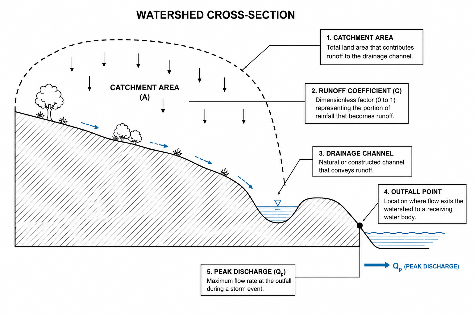
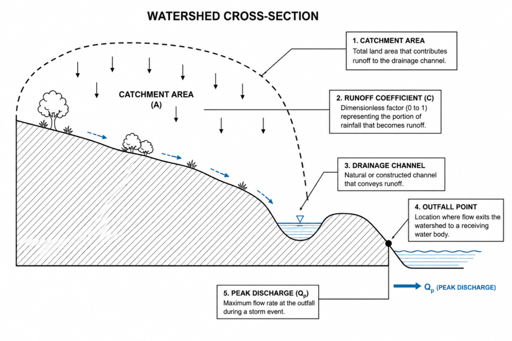
Urban drainage design typically starts with the rational method for catchments under 80 hectares: Q = CiA, where Q is peak discharge, C is the runoff coefficient (commonly 0.6–0.9 for paved estates), i is rainfall intensity for the design return period, and A is catchment area. A ten-year return period is standard for estate internal drains in most Nigerian state guidelines, while trunk drains feeding into rivers or lagoons are often designed for a 25- or 50-year event. Flood control beyond the pipe network includes embankments, retention basins, and — in flood-prone river towns — levee systems sized against historical flood-frequency data rather than a single storm event.
Water Supply and Treatment Examples
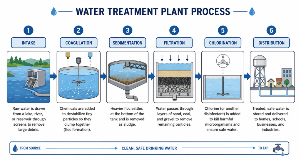
Water supply schemes range from a single borehole serving a residential compound to a treatment plant feeding an entire local government area. A borehole-fed system typically pairs a submersible pump with an overhead or underground storage tank sized for at least 24 hours of demand, while a treatment plant example involves coagulation, sedimentation, filtration, and chlorination stages designed to bring raw river or borehole water to potable standard. The Lagos Water Corporation’s Adiyan Waterworks is a working example of a large-scale surface-water treatment system that draws from the Owo River and serves a wide distribution network across mainland Lagos.
Dams, Reservoirs and Irrigation Examples
Dams and reservoirs serve three overlapping purposes in Nigerian practice: water supply storage, flood attenuation, and irrigation feed. The Kainji Dam on the River Niger remains the country’s clearest large-scale example, combining hydropower generation with downstream flow regulation. At a smaller scale, irrigation schemes in the Hadejia-Jama’are floodplain use diversion structures and canal networks to redirect seasonal flood flow into farmland, extending the growing season well beyond the natural rainfall window. Sizing any of these structures correctly depends on accurate geotechnical investigation work to confirm foundation stability before a single cubic metre of fill goes in.
Regulatory and Site Context for Water Resources Projects
Every water resources project in Nigeria answers to more than one regulatory layer. At federal level, the Nigeria Hydrological Services Agency and the Nigeria Integrated Water Resources Management Commission (NIWRMC) set policy on river basin allocation and inter-state water use. State water boards — the Lagos Water Corporation, the Federal Capital Territory Water Board in Abuja, and equivalent bodies in Rivers State — regulate supply infrastructure and abstraction permits within their territories. NESREA enforces environmental discharge standards for treated effluent, which directly affects how a treatment plant’s outfall design gets approved.
Design standards draw heavily on British Standards as adopted into Nigerian practice, since the Nigerian Industrial Standards (NIS) framework for water and drainage works references BS codes extensively. BS EN 752 governs drain and sewer design outside buildings, BS 8004 covers foundation work relevant to pump house and treatment plant structures, and BS 6349 applies where marine or waterfront works — jetties, outfall structures, reclamation bunds — come into play, particularly along the Lagos and Port Harcourt waterfronts. A COREN-registered engineer must sign off on the structural and hydraulic design before most state agencies will approve a building or development permit involving water infrastructure.
Site context changes the regulatory burden too. A borehole in a residential compound in Abuja needs a state water resources permit but rarely triggers an environmental impact assessment. A treatment plant discharging into a river, or a reclamation project altering a lagoon’s natural flow, requires a full Environmental Impact Assessment under the Federal Ministry of Environment’s framework — a process that can add six to twelve months to a project timeline if hydrological baseline data does not already exist. Engineers who scope this requirement late in design, rather than at concept stage, are the ones who end up explaining schedule slippage to a frustrated client.
Permitting aside, site investigation drives the technical decisions that regulators eventually review. A soil report showing high clay content changes the infiltration assumptions for a soakaway-based drainage design. A hydrological study showing a river’s historical flood extent changes where a pump station can safely sit. None of this paperwork is optional — it is the evidence base that supports every load calculation and every flood-level assumption made downstream.
River Basin Development Authorities add another layer specific to Nigerian water resources examples that touch shared watercourses. The Hadejia-Jama’are River Basin Development Authority, the Niger Delta Basin Development Authority, and similar bodies hold statutory responsibility for irrigation infrastructure, dam operation, and inter-state river allocation within their catchments. A contractor building an irrigation canal off a river under one of these authorities’ jurisdiction needs sign-off from that authority in addition to state-level permits — a step that catches out engineers who treat all water resources examples as falling under a single regulatory path.
Common Challenges and Cost Factors in Water Resources Projects
Cost overruns in water resources work rarely come from the obvious line items. They come from assumptions made without data. A drainage network designed on a generic rainfall figure pulled from an outdated manual, rather than current Nigerian Meteorological Agency records, can undersize pipes by 20–30% — a mistake that only becomes visible after the first major storm, when retrofitting costs far more than getting the design right the first time.
The factors that most often drive cost factors that shape water resources budgets include:
- Soil conditions — soft, waterlogged, or reclaimed ground (common across Lagos) demands deeper foundations or piling for pump stations and treatment structures, adding 15–25% to substructure costs compared to firm lateritic ground.
- Outfall availability — a site without a nearby natural drainage outfall may need pumped discharge instead of gravity flow, which adds mechanical and electrical scope plus ongoing energy cost.
- Right-of-way and land acquisition — trunk drains and canal routes crossing private land often involve compensation negotiations that delay construction starts by months.
- Maintenance access — undersized manhole spacing or inaccessible culvert locations increase long-term operating cost, since silt and debris removal becomes labour-intensive.
- Power reliability — pumped systems in areas with unstable grid supply need backup generation sized into the capital budget from day one, not added as an afterthought.
Beyond cost, the most common technical mistake is treating drainage as a standalone discipline rather than part of the wider site engineering picture. A drainage network designed before the road profile is finalised often ends up with pipe gradients that fight the final road levels, forcing redesign mid-construction. Coordinating water resources design with foundation design guide decisions early — particularly on sites with shallow groundwater — avoids the costly clash of a pump station foundation competing with a building’s raft foundation for the same constrained footprint.
Climate variability adds a longer-term cost pressure. Rainfall intensity data from even fifteen years ago increasingly understates current storm behaviour in parts of southern Nigeria, where engineers are now seeing rainfall events that exceed historical 50-year return-period assumptions. Designing strictly to old tables, without a margin for this shift, produces infrastructure that performs adequately on paper and fails in practice within a decade.
Best Practices for Delivering Water Resources Examples That Perform
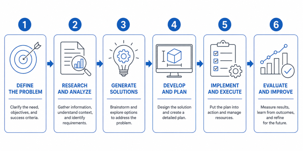
You reduce risk on a water resources project by sequencing the work correctly rather than rushing to the drawing board. The checklist below reflects the order experienced teams actually follow on Nigerian sites.
- Confirm catchment boundaries first. Walk the site or use topographic survey data to establish exactly which area drains to your point of interest before calculating peak flow — guessing the catchment boundary invalidates everything downstream.
- Use local rainfall data, not generic tables. Pull intensity-duration-frequency data specific to your state or city where available, and apply a safety margin where records are sparse or outdated.
- Investigate the soil before sizing infiltration features. Run percolation tests for soakaways and confirm bearing capacity for any structural elements — pump houses, treatment basins, retaining walls — through proper geotechnical investigation.
- Coordinate levels across disciplines early. Share road, drainage, and building foundation levels between design teams from concept stage so gradients and outfalls do not get redesigned mid-construction.
- Size for maintenance, not just peak flow. Specify manhole spacing, access chambers, and pipe self-cleansing velocities so the system stays functional five years after handover, not just on commissioning day.
- Plan the regulatory pathway before design freeze. Identify which permits — state water board, NESREA discharge consent, environmental assessment — apply to your project type, and start that process in parallel with detailed design, not after.
Where projects go wrong most often is at the handover gap between design and construction. A drainage design that specifies a particular pipe class or jointing method gets value-engineered on site without re-checking the hydraulic implications, and the as-built system performs differently from the calculation that justified it. Insisting on a construction-stage review against the original design model — not just a visual inspection — catches this before it becomes a flooding complaint two rainy seasons later.
Frequently Asked Questions About Water Resources
Q: What is water resources engineering in civil engineering?
A: Water resources engineering is the branch of civil engineering that plans, designs, and manages systems controlling the movement, storage, treatment, and distribution of water. It covers drainage networks, water supply schemes, dams, reservoirs, and irrigation infrastructure, drawing on hydrology and hydraulics to size every component against measured rainfall and flow data.
Q: How does stormwater drainage design work?
A: Stormwater drainage design starts by measuring the catchment area feeding a drainage point, then applies a rainfall intensity figure for a chosen return period — commonly 10 years for estate drains and 25–50 years for trunk systems — to calculate peak discharge using methods like the rational formula. Pipes and channels are then sized to carry that peak flow without surcharging.
Q: What are the requirements for borehole water supply in Nigeria?
A: Borehole installation requires a permit from the relevant state water resources agency, a hydrogeological survey to confirm aquifer yield and depth, and water quality testing before the supply is approved for domestic or commercial use. In Lagos and Abuja, the respective water boards also require registration of the borehole once drilled.
Q: How much does a water treatment plant cost to build?
A: Cost depends heavily on capacity, raw water source, and treatment complexity, but a small package treatment plant serving an estate of a few hundred units typically costs significantly less per litre of capacity than a large municipal works treating river water to full potable standard. Civil works, mechanical equipment, and electrical installation each contribute roughly a third of total cost on a typical mid-size scheme.
Q: What is the difference between a dam and a reservoir?
A: A dam is the physical structure — typically earth-fill, concrete, or masonry — built across a watercourse to obstruct flow. A reservoir is the body of water that accumulates behind that structure as a result. The dam is the engineering work; the reservoir is the storage outcome it creates.
The water resources examples covered here — drainage networks, treatment plants, dams, irrigation schemes, and flood control structures — share one design discipline regardless of scale: every decision traces back to measured catchment, soil, and rainfall data rather than assumption. Get that data right, sequence the investigation and regulatory steps before design freeze, and coordinate levels across disciplines early, and the resulting infrastructure performs for decades rather than failing at the first serious storm. If you are scoping a drainage network, water supply scheme, or flood mitigation project and need a design partner who understands Lagos, Abuja, and Port Harcourt site conditions specifically, StruviaCore’s hydraulic engineering team can take your project from hydrological study through to construction supervision.
Leave a Reply