
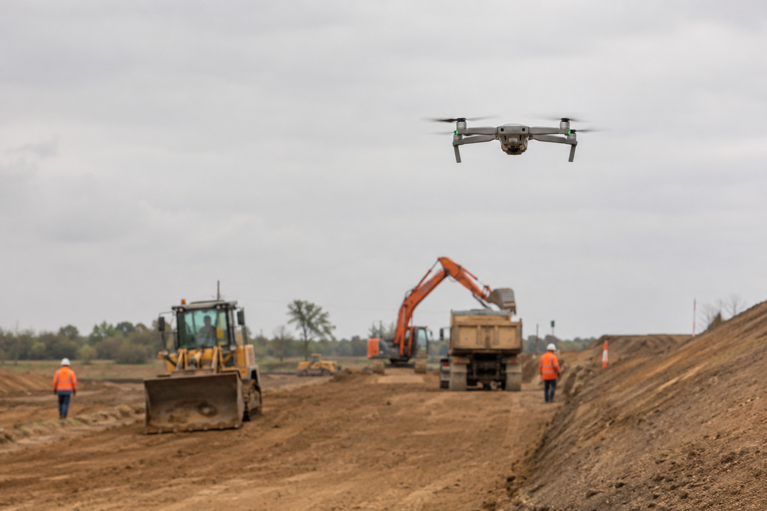
A site engineer arrives at a 40-hectare infrastructure project on a Monday morning and needs a topographic survey completed before the concrete pour can be scheduled. A decade ago, this meant a survey crew working for two to three days with total stations and GPS rovers. Today, that same engineer can launch a drone, capture the entire site in 25 minutes, and have a georeferenced point cloud processed by lunch. This shift is at the centre of how drones are reshaping civil and structural engineering practice across the UK, UAE, Nigeria, and wider West Africa. This article explains what drones do on construction sites, how the underlying technology works, where regulation stands, and what engineers need to know before deploying them on a live project.
What Is Drones: Quick Answer
Drones, or unmanned aerial vehicles (UAVs), are remotely piloted or autonomous aircraft fitted with cameras, LiDAR, or multispectral sensors used to capture aerial data on construction and civil engineering sites. Engineers use them for topographic surveying, progress monitoring, structural inspection, and volumetric calculations, replacing slower manual survey methods with faster, repeatable aerial data capture.
What Is Drones in Civil Engineering Practice
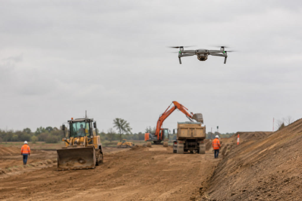
Drones are unmanned aerial vehicles that carry sensors, cameras, or scanning equipment over a site and transmit that data back to a ground station or cloud platform for processing. In civil engineering, the aircraft itself is rarely the point of interest — the value sits in the data it collects and how that data feeds into design, monitoring, and quality control workflows. A unit fitted with a RGB camera can generate an orthomosaic map accurate to 2-3cm. The same aircraft fitted with LiDAR instead can penetrate light vegetation cover to produce a bare-earth digital terrain model, and one carrying a thermal sensor can detect moisture ingress on a flat roof or delamination on a bridge deck that is invisible to the naked eye.
On a typical project, drones fall into three operational categories: fixed-wing aircraft for large-area mapping (highway corridors, rail alignments, mining sites), multi-rotor aircraft for detailed close-range inspection (bridge soffits, tank interiors, building facades), and hybrid VTOL platforms that combine vertical takeoff with fixed-wing endurance for medium-to-large sites. The choice of platform depends on site size, required resolution, and access constraints — a 200-hectare rail corridor in Kaduna State calls for a different aircraft than a 15-storey building facade inspection in Dubai.
How Drone Data Becomes Engineering Information
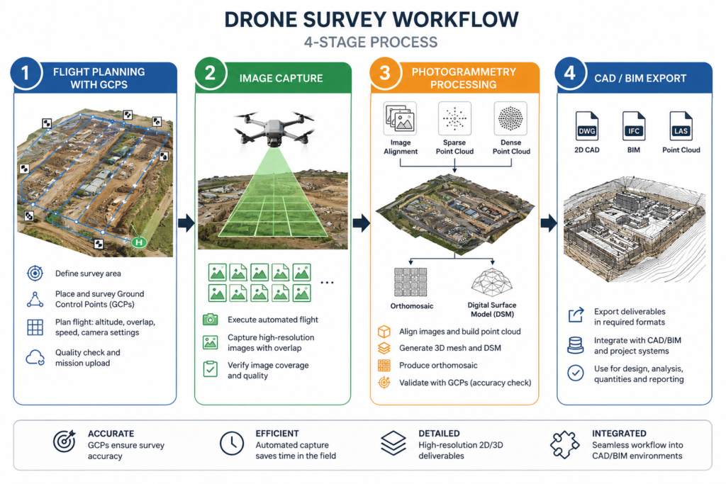
Raw aerial imagery is not directly useful to a structural or civil engineer. The workflow that converts flight data into usable engineering deliverables typically follows four steps. First, the aircraft captures overlapping images or point-cloud data during a pre-planned flight, usually with 70-80% front overlap and 60-70% side overlap for photogrammetry accuracy. Second, ground control points (GCPs) are surveyed independently using GNSS receivers to anchor the aerial data to a known coordinate system — without GCPs, the resulting survey can drift by several metres. Third, photogrammetry software such as Pix4D, DJI Terra, or Agisoft Metashape stitches the images into an orthomosaic and generates a 3D point cloud through structure-from-motion processing. Fourth, the point cloud is classified, cleaned, and exported into formats — DWG, LAS, IFC — that feed directly into CAD, GIS, or BIM environments used across the BIM workflow on a project. Flight planning software such as DJI Pilot or Pix4D Capture lets the pilot pre-programme the grid pattern, altitude, and overlap percentage before takeoff, removing guesswork from the capture stage and making the flight repeatable across successive site visits.
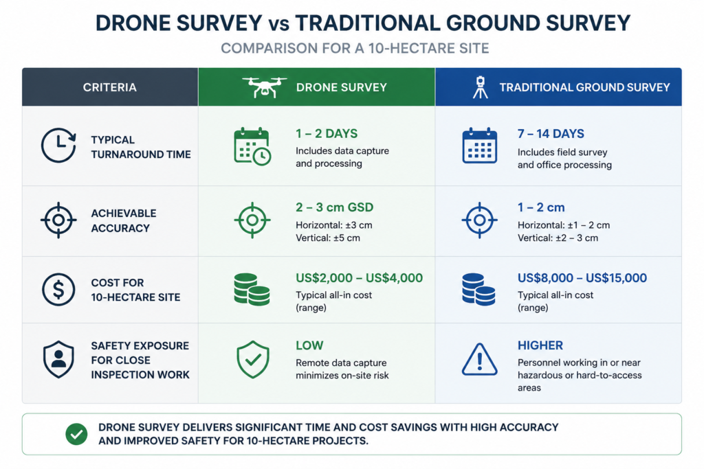
Accuracy depends heavily on GCP density and camera calibration. A well-executed drone survey with sufficient ground control can achieve horizontal accuracy of 1-2cm and vertical accuracy of 2-3cm, which is within tolerance for most earthworks quantity surveys but insufficient for final as-built structural surveys, where total stations remain the standard.
Technical Applications: Surveying, Inspection, and Monitoring
Three applications account for most drone use on civil engineering projects. Topographic surveying and volumetric analysis is the most established use case. Instead of a manual cross-section survey taking days, a drone flight captures the full site extent, and photogrammetry software calculates cut-and-fill volumes automatically by comparing the captured surface against a design model. On a road realignment project in Lagos, for instance, this can reduce survey turnaround from a week to under 48 hours, directly shortening the earthworks certification cycle.
Structural and asset inspection is the second major category. Bridge soffits, tall building facades, cooling towers, and offshore or marine structures are difficult, slow, and often dangerous to inspect using rope access or scaffolding. A drone equipped with a high-resolution zoom camera can identify cracking, spalling, corrosion staining, and reinforcement exposure on a bridge deck without closing a lane of traffic — a direct benefit on live infrastructure covered under Network Rail and highways authority inspection regimes in the UK, and increasingly adopted for marine infrastructure inspection in coastal and port environments.
Progress Monitoring and Quantity Verification
The third major application is construction progress monitoring. A weekly or fortnightly drone flight over an active site generates a time-stamped orthomosaic that project managers overlay against the programme baseline. This is used to verify contractor progress claims, track material stockpile volumes for procurement reconciliation, and produce visual records for dispute resolution. On large infrastructure programmes, this progress data increasingly feeds into digital twin platforms, where the drone capture becomes one input layer alongside sensor and design data.
Data Management and Integration with Design Workflows
A completed flight is only the start of the value chain. The processed point cloud or orthomosaic has to move into the tools the design team already uses, and this integration step is where many aerial capture programmes lose momentum. Point cloud data exported as LAS or LAZ files loads into Civil 3D or similar terrain-modelling software, where it can be converted into a triangulated surface for cut-and-fill analysis or overlaid against a proposed formation level to check earthworks tolerances. Orthomosaic imagery, meanwhile, is commonly brought into GIS platforms as a georeferenced raster layer, letting planners overlay utility records, drainage catchments, or existing utilities mapping against the current site condition.
Where a project runs a live BIM environment, the aerial survey is increasingly registered directly as a federated model layer rather than treated as a standalone deliverable. This lets the design team compare the as-captured ground condition against the design model on a rolling basis rather than waiting for a formal survey milestone, catching discrepancies — an unrecorded services trench, an unexpected change in formation level — before they become a variation. On projects with recurring capture cycles, storing successive point clouds under version control also builds a time-series record that supports settlement monitoring and post-construction dispute evidence, which is particularly valuable on urban infrastructure schemes where third-party asset protection is a live risk throughout construction.
Regulatory Context Across the UK, UAE, and Nigeria
Flying an aircraft on a construction site is not an unregulated activity — each jurisdiction StruviaCore operates in has a distinct airspace and safety framework that governs how, where, and by whom a UAV can be flown commercially. In the UK, commercial operators must hold a General Visual Line of Sight Certificate (GVC) issued under Civil Aviation Authority (CAA) rules, and flights near occupied structures or within controlled airspace require additional Operational Authorisations. Sites governed by CDM 2015 also require the flight itself to be assessed as a construction activity, meaning the principal contractor must account for it in the construction phase plan.
In the UAE, aerial operations fall under the General Civil Aviation Authority (GCAA), which requires operator registration, pilot licensing, and site-specific flight permissions — particularly relevant given the proximity of many Dubai and Abu Dhabi construction sites to controlled airspace around major airports. Projects near Dubai International or Al Maktoum International routinely require coordination with GCAA and Dubai Municipality before a flight plan is approved, and permit turnaround for sites inside restricted zones can run to several weeks rather than days.
In Nigeria, the Nigerian Civil Aviation Authority (NCAA) regulates UAV operations under its Unmanned Aircraft Systems regulations, requiring operator certification and permits for commercial flights. COREN-registered engineers commissioning aerial surveys for design or as-built verification should confirm the operator holds current NCAA authorisation, since survey data obtained without proper permits can create liability exposure on projects requiring regulatory sign-off. NESREA environmental clearance processes on larger infrastructure projects have also begun accepting this captured baseline environmental data as supporting evidence, and several state ministries of works now request aerial progress imagery alongside conventional site diaries for large public contracts.
Common Challenges and Cost Factors
Adoption is not without friction, and engineers evaluating whether to bring capability in-house or outsource to a specialist operator need to weigh several recurring issues. Weather sensitivity is the most immediate operational constraint — most commercial multi-rotor aircraft cannot fly safely in winds above 25-35 km/h or in rain, which limits flight windows during Nigeria’s wet season or UK winter months and can push survey schedules by days on programme-critical dates.
Data processing time is frequently underestimated. While flight capture might take an hour, photogrammetry processing for a large site can take 8-24 hours of computing time, and someone on the team needs the GIS or photogrammetry software competency to QA the output before it is issued for design use. Battery endurance limits typical multi-rotor flight time to 20-30 minutes per charge, meaning larger sites require multiple battery swaps or a fixed-wing platform with longer endurance. Operators should also budget for staff training: a pilot needs practical flight hours beyond the licensing exam to fly confidently in constrained sites with cranes, scaffolding, and overhead cabling, and most consultancies find it takes several months of regular flying before an in-house pilot reaches the competency needed for unsupervised inspection work.
On cost, a basic drone survey package for a site under 10 hectares typically runs lower than an equivalent ground survey crew day rate, but the economics shift as site size, required accuracy, and sensor complexity increase. LiDAR-equipped platforms and thermal inspection aircraft carry higher day rates than standard RGB photogrammetry setups, and specialist inspection work — bridge soffits, offshore structures — commands a premium over routine topographic capture. Engineers scoping a survey should request the deliverable format (LAS point cloud, DWG contours, IFC model) up front, since re-processing raw data into a different format later adds cost that is easy to avoid with clear scoping.
Data Security and Site Access Considerations
A less obvious but increasingly relevant challenge is data governance. Aerial imagery captured over an active site can inadvertently record adjoining properties, ongoing operations at a neighbouring facility, or personnel movements — all of which raise privacy and security questions on sensitive projects such as government buildings, ports, or airport-adjacent works. Contractors should agree in advance who owns the captured data, how long it is retained, and where footage is stored, particularly on projects governed by client confidentiality clauses or national security restrictions near airport perimeters covered by the GCAA in the UAE or CAA in the UK.
Airspace access itself can also be a limiting factor rather than a technical one. Sites within a few kilometres of an active runway, a military installation, or a designated no-fly zone may require flight authorisation windows measured in weeks rather than days, and project programmes that assume same-week drone availability without checking this in advance frequently run into avoidable delay. Building airspace clearance lead time into the programme at tender stage, rather than discovering the restriction once mobilised, keeps this from becoming a critical-path risk.
Best Practices for Deploying Drones on a Project
Getting reliable, design-ready data from a drone survey depends on process discipline before, during, and after the flight. You should follow a consistent sequence on every project rather than treating each flight as a one-off.
- Confirm regulatory clearance first. Verify the operator’s CAA, GCAA, or NCAA certification and airspace clearance before scheduling the flight — do this at least two weeks ahead near controlled airspace.
- Place and survey ground control points independently. Use GNSS-surveyed GCPs distributed evenly across the site, with a minimum of five points for sites under 20 hectares, more for larger or irregular sites.
- Match the sensor to the deliverable. Specify RGB photogrammetry for topographic and volumetric work, LiDAR for vegetated or obstructed sites, and thermal or high-zoom optical sensors for defect inspection.
- Define the output format before the flight. Agree whether the deliverable is a LAS point cloud, DWG contour file, or IFC model, so processing is done once and correctly.
- Cross-check accuracy against a control survey. Spot-check the processed drone data against three to five independently surveyed points to confirm the stated accuracy tolerance before the data is used for design or certification.
Following this sequence consistently is what separates a drone survey that holds up under design scrutiny from one that introduces avoidable rework later in the project.
Frequently Asked Questions About Drones
Q: What is drones in civil engineering used for?
A: Drones are used in civil engineering for topographic surveying, cut-and-fill volume calculation, construction progress monitoring, and structural inspection of bridges, buildings, and marine infrastructure. They replace or supplement traditional ground survey and visual inspection methods with faster aerial data capture, typically reducing large-site survey turnaround from several days to under 48 hours.
Q: How does a drone survey work on a construction site?
A: A drone flies a pre-planned grid pattern capturing overlapping images or LiDAR data, while ground control points surveyed by GNSS anchor the data to real-world coordinates. Photogrammetry software then processes the captured data into an orthomosaic map and 3D point cloud, which is exported into CAD or BIM formats such as DWG or IFC for design use.
Q: How much does a drone survey cost compared to a traditional survey?
A: For sites under 10 hectares, a standard RGB drone survey is generally cheaper than an equivalent ground survey crew, though costs rise with site size, LiDAR sensor use, or specialist inspection requirements. Engineers should request pricing based on the specific deliverable format needed, since reprocessing data into a different format after capture adds cost.
Q: What licences or permits are required to fly a commercial drone on a construction site?
A: Requirements vary by country: the UK requires a CAA-issued General Visual Line of Sight Certificate, the UAE requires GCAA operator registration and site-specific flight permissions, and Nigeria requires NCAA certification under its Unmanned Aircraft Systems regulations. Sites near controlled airspace, such as those close to Dubai International Airport, often need additional coordination before a flight is approved.
Q: What is the difference between a drone survey and a traditional total station survey?
A: A drone survey captures an entire site as a continuous point cloud or orthomosaic in a single flight, achieving 1-3cm accuracy with proper ground control, while a total station survey captures discrete points one at a time with sub-centimetre accuracy. Total stations remain the standard for final as-built structural verification, while drones are preferred for large-area topographic and volumetric work.
Drones have moved from a novelty to a standard tool in the civil engineering surveyor’s kit, and the engineers getting the most value from them are the ones treating drone data with the same rigour applied to any other survey input — verified ground control, defined accuracy tolerances, and clear deliverable formats agreed before the flight leaves the ground. Used well, drones cut survey turnaround from days to hours and make inspection of hard-to-access structures safer and more frequent. Used carelessly, they generate data that looks precise but fails design scrutiny. If your project could benefit from faster, more accurate site data capture, StruviaCore’s engineering team can help you scope a drone survey that meets your accuracy and regulatory requirements from the outset.
Leave a Reply