

Ask a traffic engineer in Lagos or a utilities manager in Dubai what “smart” actually means on a live project, and you get a different answer than the marketing brochures suggest. A smart traffic signal that adjusts timing based on real vehicle counts is smart. A dashboard that nobody monitors is not. Understanding how smart cities work means separating the sensor networks and data pipelines that deliver measurable outcomes from the buzzwords layered on top. This article covers the technical architecture behind smart city systems, how they integrate with existing civil infrastructure, the regulatory frameworks that govern deployment across the UK, UAE, and West Africa, and the practical challenges engineers face when specifying these systems on real projects.
Smart cities are urban systems that use networked sensors, data platforms, and automated controls to manage infrastructure — traffic, utilities, water, waste, and public safety — more efficiently than manual or purely mechanical systems allow. The remainder of this guide walks through the architecture layer by layer, from field sensors to the control room decisions that follow.
Smart Cities: Quick Answer
Smart cities work by connecting physical infrastructure to sensor networks that collect real-time data, transmitting that data over wired or wireless networks to central platforms, and using analytics or automated controls to adjust operations. A traffic signal that responds to live congestion, a water main that reports pressure drops before a burst, and a streetlight that dims when no pedestrians are present are all smart city systems in practice.
The Core Architecture: How Smart City Systems Actually Function
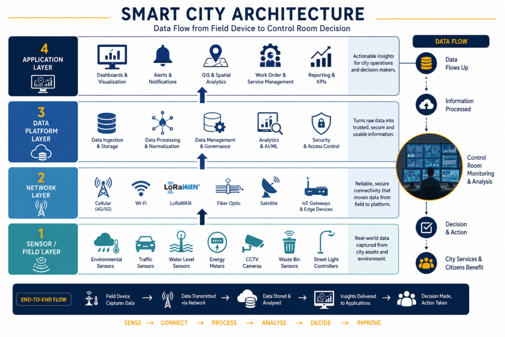
Every functioning smart cities deployment, regardless of sector, runs on the same four-layer stack. Strip away the vendor branding and you find sensors, networks, platforms, and applications — in that order, every time. A project manager reviewing a smart utilities proposal should ask which layer a vendor is actually selling, because most pitches conflate two or three layers into one glossy term.
Sensor and Field Device Layer
This is the physical layer — pressure transducers on water mains, inductive loop detectors or radar units at intersections, particulate matter sensors on lamp posts, and flow meters in stormwater networks. Sensor selection drives everything downstream. A vibrating wire piezometer reporting groundwater levels every 15 minutes generates a fundamentally different data volume and reliability profile than a battery-powered LoRaWAN soil moisture sensor reporting hourly. Engineers specifying these systems need to match sensor accuracy and reporting frequency to the actual decision being made — you do not need sub-second traffic counts to plan a signal retiming study that runs on monthly aggregates.
Communication Network Layer
Field devices need a path back to a central platform. Options split broadly into cellular (4G/5G, NB-IoT), low-power wide-area networks (LoRaWAN, Sigfox), and fixed fiber or Ethernet for high-bandwidth applications like CCTV analytics. Network choice depends on power availability, data volume, and latency tolerance. A pump station telemetry system with mains power and a need for near-instant fault alerts justifies fiber or cellular. A network of 400 street-level air quality sensors spread across a low-density urban expansion in Abuja is a better fit for LoRaWAN, where devices run for years on a single battery and tolerate 10–15 minute reporting intervals.
Coverage gaps are the practical constraint most often underestimated at design stage. Sensor networks that perform well in a dense city core frequently lose reliability at the urban fringe, where cellular signal strength drops and LoRaWAN gateway spacing becomes the limiting factor. Site surveys during detailed design should include radio frequency testing at the actual sensor locations, not just desktop coverage maps.
Gateway placement for LoRaWAN networks deserves the same rigour as any line-of-sight survey. A single gateway mounted at 15–20 metres height on a suitably located structure can cover a radius of several kilometres in open terrain, but dense mid-rise development, structural obstructions, and foliage cut that range sharply. On projects across Lagos and Port Harcourt, where building density and seasonal foliage growth both interfere with signal propagation, a gateway spacing that looked adequate on a desktop RF model has more than once needed revision after a live pilot showed dead zones on specific streets. Build a pilot phase with a small number of gateways into the programme before committing to the full network rollout — it is a fraction of the total capital cost and catches these issues before mass deployment.
Data Platforms, Analytics, and Automated Control
Raw sensor data has limited value until it passes through a platform that aggregates, cleans, and contextualizes it. This is where most smart cities budgets are spent, and where most failed projects lose momentum — not because the sensors did not work, but because nobody built the platform layer that turns readings into decisions. Understanding this layer is central to understanding how smart cities work in practice, because the platform is where raw numbers become an operational decision.
Data Aggregation and the Digital Twin Model
A growing number of municipal clients now request that smart city data feed into a connected infrastructure model rather than a standalone dashboard. In practice this means sensor readings are mapped onto a spatial model of the asset — a water network, a road corridor, a drainage catchment — so that an engineer reviewing pressure anomalies can immediately see which pipe segment, which valve, and which upstream demand pattern is involved. This spatial linkage is what separates a functioning digital asset model from a spreadsheet of readings with timestamps.
Automated Control Logic
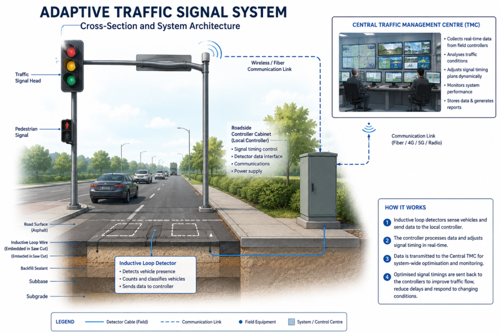
Some smart city applications close the loop without human intervention. Adaptive traffic signal control systems adjust green-phase duration based on live queue length, typically within pre-set bounds agreed during commissioning — a signal will rarely be permitted to extend a phase beyond 90 seconds regardless of demand, because pedestrian crossing intervals and cross-street minimums are fixed by local traffic engineering standards. Pressure-managing valves in water networks similarly adjust automatically to reduce leakage during low-demand periods, typically overnight, based on preset pressure thresholds validated during network modelling.
Automated control introduces a design responsibility that manual systems do not carry: the failure mode must be defined explicitly. If the communication link to a pressure-reducing valve drops, does the valve hold its last setting, default to a safe fixed position, or fail open? This is a specification decision, not an afterthought, and it belongs in the functional design specification reviewed at concept stage, not resolved on site during commissioning. It is precisely this kind of decision that determines whether smart cities infrastructure performs reliably under real operating conditions rather than only during vendor demonstrations.
The same principle applies to public safety systems, where the stakes for an undefined failure mode are higher. CCTV analytics platforms used for incident detection on urban corridors typically flag anomalies — a stalled vehicle, a pedestrian in a restricted zone — for human review rather than triggering fully automated intervention. Full automation is generally reserved for lower-consequence adjustments, such as dimming streetlighting when no motion is detected, where a false trigger costs nothing more than a few seconds of reduced illumination. Engineers scoping these systems need to draw that line explicitly with the client during the functional requirements stage, because vendors selling analytics platforms will often present detection accuracy figures without addressing what happens operationally when the system is wrong.
Regulatory Context: UK, UAE, and West African Frameworks
Smart cities deployment does not sit outside existing infrastructure regulation — it sits on top of it, and engineers who treat it as a separate IT project rather than an infrastructure project under existing codes create compliance gaps. This is a consistent pattern across every jurisdiction StruviaCore works in: the regulatory bodies governing smart cities projects are the same bodies that govern conventional civil works, not a separate technology regulator.
In the UK, smart infrastructure projects involving construction works remain subject to CDM 2015 regulations for the physical installation phase — trenching for fiber, mounting sensor cabinets, and modifying traffic signal cabinets all trigger standard CDM duties on principal designers and contractors. Structural elements supporting sensor gantries or communication masts are designed to the relevant Eurocodes, typically Eurocode 1 for wind loading on mast-mounted equipment and Eurocode 3 where steel gantry structures are involved.
In the UAE, smart city rollouts — Dubai’s in particular — operate under Dubai Municipality building and infrastructure permitting requirements, with the General Civil Aviation Authority (GCAA) holding jurisdiction over any sensor or communication infrastructure near airport approach paths, which matters directly for smart lighting and traffic corridors near Dubai International and Al Maktoum International.
In Nigeria, engineers working on smart infrastructure need sign-off pathways that satisfy COREN registration requirements for the civil works component, alongside NESREA environmental compliance where sensor installation disturbs drainage or green infrastructure, and NCAA coordination where communication masts fall within airport-restricted zones around Lagos or Abuja. A common gap on West African smart cities pilots is treating the sensor and software procurement as exempt from local engineering sign-off because it is framed as “technology” rather than “infrastructure” — this framing does not hold up under COREN’s scope of regulated engineering work once the installation involves structural mounting, power distribution, or civil trenching.
Common Challenges and Cost Factors
Smart cities projects fail more often from integration gaps than from sensor hardware faults. Four issues recur across the smart cities projects StruviaCore reviews.
- Legacy infrastructure incompatibility. Retrofitting sensors onto a 30-year-old water network built without as-built GIS data means the first project cost is often a network survey and digitisation exercise, not the sensors themselves. Budget for this explicitly — it commonly runs to 15–20% of total project cost on undocumented networks.
- Platform vendor lock-in. Proprietary data formats that cannot export to open standards like NGSI-LD or open GIS formats leave clients unable to switch vendors or integrate a second sensor supplier without a costly migration. Specify open data standards in the procurement documents, not after contract award.
- Power resilience gaps. Sensor networks tied to grid power without battery backup fail during the exact events — storms, floods, grid outages — when the data matters most. A flood sensor network that goes dark during a flood has no operational value.
- Underestimated data governance cost. Municipal clients frequently underbudget the ongoing cost of data validation, cybersecurity patching, and platform licensing, treating smart infrastructure as a one-time capital cost rather than a system with a 10–15% annual operating cost relative to capital spend.
Cost per sensor node varies widely by application. A basic LoRaWAN environmental sensor with a five-year battery life typically costs less than a comparable cellular-connected unit with continuous power draw, but the cellular unit avoids the battery replacement labour cost that accumulates across a network of several hundred nodes. Run a total-cost-of-ownership comparison over the expected asset life, not a unit price comparison, before selecting a communication technology.
A fifth issue worth flagging separately is procurement sequencing. Clients frequently issue a tender for the sensor and platform package before the civil and structural scope — mast foundations, cabinet mounting, power distribution — has been through detailed design. This reverses the correct order. The technology procurement should follow the civil design, not precede it, because sensor mounting heights, cable route lengths, and power capacity all constrain which sensor models and network topology are viable. Reviewing the civil scope first typically shortens the overall design programme by removing a redesign cycle later, once the technology vendor’s physical requirements collide with a foundation or cabinet layout that was never sized for them.
Best Practices for Specifying Smart City Systems
You do not need to become a telecoms engineer to specify smart cities infrastructure competently, but you do need a checklist that keeps the civil and structural scope aligned with the technology scope.
- Define the decision before the sensor. Every sensor in the design should trace back to a specific operational decision it informs. If you cannot name the decision, question whether the sensor belongs in the scope.
- Set failure-mode requirements at concept design. Document what each automated system does when connectivity, power, or data quality fails, and include this in the functional specification reviewed by the client.
- Require open data standards contractually. Specify export formats and API access in the procurement documents to prevent vendor lock-in at handover.
- Coordinate structural and civil scope early. Mast foundations, gantry structures, and cabinet mounting need the same geotechnical and structural sign-off as any other permanent structure — do not let the technology procurement bypass structural review.
- Plan the data governance budget as an operating cost. Present the client with a five-year total cost of ownership figure, not just the capital sum, at the business case stage.

Frequently Asked Questions About Smart Cities
Q: What is a smart city in civil engineering terms?
A: Smart cities, from a civil engineering standpoint, are urban areas where physical infrastructure — roads, water networks, utilities, buildings — is instrumented with sensors and connected to data platforms that inform maintenance, operational, and planning decisions. Smart cities represent an infrastructure management approach, not a separate category of construction.
Q: How does smart cities work with existing urban planning processes?
A: Smart city data feeds into urban planning decisions by providing real usage data — actual traffic volumes, water demand patterns, pedestrian movement — that replaces or supplements traditional survey-based planning inputs. Planners use this data to validate zoning decisions, size infrastructure upgrades, and prioritise capital works against measured demand rather than projected demand alone.
Q: What are the smart cities infrastructure requirements for a typical mid-size deployment?
A: A typical deployment requires a sensor network matched to the target application, a communication backbone (cellular, LoRaWAN, or fiber depending on data volume and power constraints), a data platform capable of aggregation and analytics, and defined governance covering data ownership, cybersecurity, and maintenance responsibility. Structural and civil works for mounting and power supply follow standard code compliance in the relevant jurisdiction.
Q: How much does a smart city sensor network cost per square kilometre?
A: Costs vary significantly by sensor density and application, but municipal traffic and utilities deployments commonly range from moderate five-figure to low six-figure sums per square kilometre in urban core areas, driven primarily by sensor density, network infrastructure gaps, and whether existing conduit or duct routes are available for cabling.
Q: What is the difference between smart cities and connected infrastructure?
A: Connected infrastructure refers specifically to the networked physical assets — the sensors, communication links, and control systems on a given asset type such as a water network or road corridor. Smart cities is the broader term covering the integration of multiple IoT-enabled systems — transport, utilities, safety, buildings — into a coordinated urban management approach.
Q: How does urban mobility fit into smart city systems?
A: Urban mobility systems — adaptive traffic signals, real-time transit tracking, parking sensors — are typically the most visible and earliest-deployed component of a smart city programme because they generate measurable congestion and emissions benefits within a short payback period, making them easier to justify in an initial business case than longer-payback utilities investments.
Smart cities work through a straightforward technical chain — sensors collect data, networks transmit it, platforms process it, and either engineers or automated systems act on it. The complexity that trips up projects sits not in any single layer but in the integration between them: matching sensor selection to communication technology, aligning automated control failure modes with operational risk tolerance, and satisfying the same structural and regulatory obligations that apply to any permanent infrastructure. None of this replaces sound civil engineering judgement — a pressure sensor cannot compensate for an undersized water main, and a traffic analytics platform cannot fix a junction geometry that was wrong at design stage. Smart infrastructure adds a data layer on top of correct engineering; it does not substitute for it. Engineers who treat smart city components as infrastructure projects first and technology projects second deliver systems that survive past the pilot phase. For guidance on specifying sensor networks, digital asset models, or smart cities infrastructure for a specific project, contact StruviaCore’s infrastructure engineering team.
Leave a Reply