
Walk along any engineered riverbank in the UK — the Thames Barrier, the flood relief channels in Peterborough, the tidal defences along the Humber estuary — and you are looking at hydraulic engineering made physical. The discipline is often underestimated in early project scoping, treated as a sub-discipline to be engaged once the structural frame is resolved. That is the wrong sequence. Hydraulic engineering shapes site viability, drainage strategy, flood risk classification, and long-term asset performance. When it enters a project late, costs climb and programme suffers. When it enters early, it becomes one of the most bankable decisions a project team makes. This article sets out the concrete, quantifiable benefits of hydraulic engineering — from stormwater attenuation to whole-life cost reduction — and explains how those benefits translate into value on live UK projects.
Hydraulic Engineering Benefits: Quick Answer
Hydraulic engineering is the branch of civil engineering concerned with the flow, control, and distribution of water in natural and built environments. Its benefits include reduced flood risk, lower long-term drainage costs, regulatory compliance under the Flood and Water Management Act 2010, improved water quality outcomes, and enhanced asset resilience across roads, buildings, and utilities infrastructure.

What Hydraulic Engineering Actually Does on a Project
Hydraulic engineering is the applied science of controlling, conveying, and managing water — in channels, pipes, reservoirs, estuaries, and porous ground. It draws on fluid mechanics, hydrology, soil science, and environmental regulation to answer a deceptively simple question: where does the water go, how fast, and with what force?
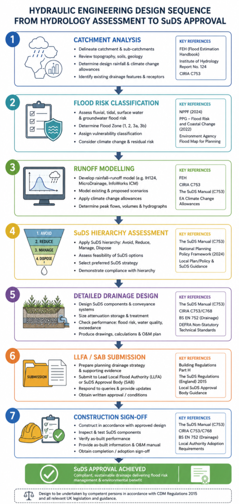
On a typical UK development, the hydraulic engineer is responsible for flood risk assessment (FRA) under the National Planning Policy Framework (NPPF), surface water drainage strategy under Schedule 3 of the Flood and Water Management Act 2010 (mandatory in Wales since 2018, increasingly enforced in England), and culvert or outfall design that satisfies Environment Agency consenting requirements. Beyond development, the discipline extends to river engineering, coastal and estuarine management, reservoir design, potable water distribution networks, and wastewater treatment hydraulics.
The Regulatory Framework in the UK
In England, any major development in Flood Zone 2 or 3 requires a site-specific FRA that demonstrates the development is safe for its lifetime, does not increase flood risk elsewhere, and incorporates mitigation measures where necessary. The assessment must reference Environment Agency flood maps, historic flood records, and modelled flood extents — typically produced using industry-standard tools such as HEC-RAS, InfoWorks ICM, or MIKE FLOOD. Planning authorities will not validate a major application without it.
Surface water drainage is assessed against the SuDS (Sustainable Drainage Systems) hierarchy: infiltration first, then attenuation with controlled discharge, then piped systems as a last resort. Post-2018 Welsh regulations mandate SuDS approval by a Statutory Approving Body (SAB) before construction begins. England is moving in the same direction under Schedule 3 commencement orders. A hydraulic engineer who understands both the technical standard and the approval process removes a significant programme risk from your project.
For projects near ordinary watercourses, consenting under the Land Drainage Act 1991 falls to the Lead Local Flood Authority (LLFA). For main rivers, the Environment Agency holds jurisdiction. Getting this wrong — discharging without consent, culverting without approval — results in enforcement notices, mandatory removal, and in serious cases, criminal liability for the developer. The hydraulic engineer manages these interfaces as a matter of course.
The Technical Benefits of Hydraulic Engineering in Detail
Benefits are most defensible when they are specific. Below are the primary technical gains that hydraulic engineering delivers, with reference to the standards and mechanisms that underpin each one. For a wider grounding in water systems design, the water resources guide on struviacore.com provides a complementary reference.
Flood Risk Reduction and Site Viability
The single most consequential benefit hydraulic engineering delivers is flood risk reduction. In the UK, approximately 5.2 million properties are at risk of flooding from rivers or the sea, according to the Environment Agency. A competent FRA does not just demonstrate compliance — it can unlock sites that would otherwise be rejected at pre-application stage.
Consider a brownfield site in Flood Zone 2 adjacent to a culverted watercourse. Without hydraulic assessment, the planning authority will likely refuse on flood risk grounds. With a modelled FRA that demonstrates the culvert capacity, identifies the flood extent under a 1-in-100-year event plus a 20% climate change allowance (as required by the NPPF Technical Guidance), and proposes finished floor levels that place habitable areas above the design flood level, the same site becomes developable. That is not a marginal gain — it is the difference between a viable site and a written-off asset.
Hydraulic modelling also quantifies the benefit of mitigation. A flood storage basin upstream of a development can attenuate peak flows by 30–60%, depending on catchment size and storm profile. This figure translates directly into a reduction in design flood level downstream, which reduces foundation depths, waterproofing specifications, and insurance premiums across the life of the asset.
Surface Water Management and SuDS Performance
Conventional piped drainage degrades over time, requires routine maintenance, and — when overwhelmed by intense rainfall — causes sewer flooding. A well-designed SuDS scheme addresses all three problems simultaneously.
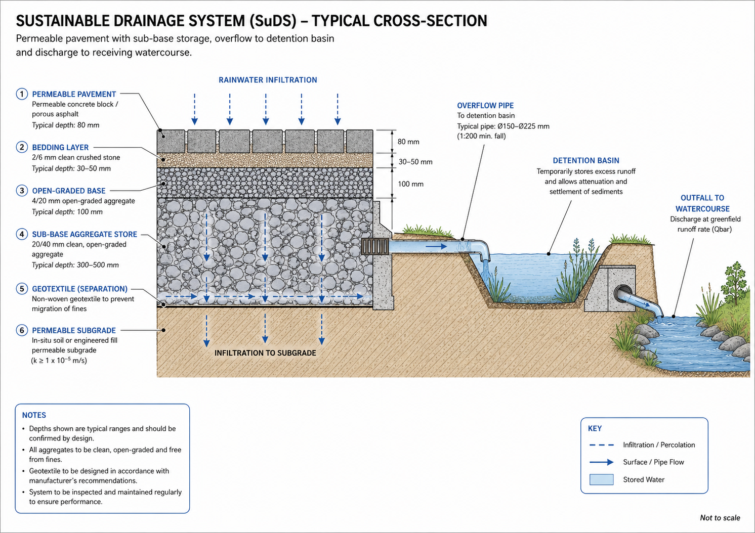
Permeable paving, green roofs, swales, detention basins, and filter strips slow the velocity of runoff, reduce peak discharge rates to greenfield equivalents (typically 2–5 litres per second per hectare for sites in sensitive catchments), and improve water quality by intercepting suspended solids, hydrocarbons, and heavy metals before they reach the receiving watercourse. The CIRIA SuDS Manual (C753, 2015) provides the design standards that UK drainage engineers work to.
The economic case for SuDS is well-established. A 2014 Environment Agency study found that every £1 invested in flood risk management returns £8 in avoided damages on average. SuDS schemes with amenity value — naturalistic swales through landscaped public realm, for example — generate additional benefits in biodiversity net gain (BNG) credits, now mandatory for new developments in England under the Environment Act 2021. A swale designed to hydraulic function and planted to BNG specification delivers drainage compliance and ecological gain from a single piece of infrastructure. That is efficient engineering.
Hydraulic Engineering Benefits Across Infrastructure Sectors
The benefits described above are not confined to greenfield development. Hydraulic engineering generates measurable value across multiple infrastructure sectors, and understanding these applications helps project managers specify the right input at the right stage.
Roads and highways: Highway drainage is governed by the Design Manual for Roads and Bridges (DMRB), specifically Volume 4 Section 2 Part 1 (HA 102/17 in updated guidance). Hydraulic engineers design filter drains, gullies, and detention ponds that intercept and treat road runoff before discharge. On major schemes, they also assess the risk of road flooding from overland flow and size culverts under carriageways to pass design flood events — typically the 1-in-100-year event with 20% climate change. An under-sized culvert washes out under extreme rainfall; the remediation costs routinely exceed the original design saving. If you want to understand how drainage fits into the wider transport network, the transportation engineering guide covers the intersection of hydraulic and pavement design in more detail.
Bridges and structures: Hydraulic engineering determines the bridge waterway opening — the minimum clear span needed to pass design flows without causing backwater effects or scour. The UK standard for bridge hydrology is set out in BD 97/12 (Hydraulic Design of Bridges). Scour is the single most common cause of bridge failure in the UK; the hydraulic assessment of scour potential and the design of countermeasures (such as riprap, sheet piling, or bed-level monitoring) is a specialist task that directly affects structural safety. The bridges guide explores the structural interface in greater depth.
Urban infrastructure and drainage networks: Combined sewer overflow (CSO) events — where overloaded sewers discharge untreated sewage into watercourses — are a live and politically charged issue in the UK following the Storm Overflows Discharge Reduction Plan (2022). Water companies and local authorities are commissioning hydraulic assessments of existing sewer networks to identify capacity constraints, model the effect of surface water separation schemes, and design interception storage. The hydraulic engineer’s ability to model the existing system under projected growth scenarios is the foundation of every capital investment decision in this space.
Marine and coastal infrastructure: Coastal hydraulic engineering encompasses wave analysis, tidal modelling, and the design of seawalls, revetments, and breakwaters. With sea levels projected to rise by 0.26–0.82m by 2100 under IPCC RCP4.5 scenarios, coastal defence design life and freeboard assumptions are under active review. The marine infrastructure guide addresses the specific challenges of coastal and tidal environments.
Common Mistakes That Erode the Benefits of Hydraulic Engineering
The discipline generates outsized returns when engaged correctly — and significant losses when handled carelessly. These are the failure modes that repeat across UK projects.
Engaging the hydraulic engineer too late. The most common and most costly mistake. When drainage strategy is treated as a detail to be resolved at detailed design, the scheme layout is often already fixed around a drainage concept that cannot meet the LLFA’s greenfield runoff rate requirement. Retrofitting SuDS into an established layout means losing developable plots, rerouting service corridors, and sometimes redesigning access routes. The hydraulic engineer should attend the concept design stage, not the pre-planning submission stage.
Using desktop flood map data as a substitute for site-specific modelling. Environment Agency flood maps are indicative, not definitive. They are based on generalised hydraulic models and may not reflect local drainage constraints, recent watercourse modifications, or the influence of surface water flooding from adjacent fields. A site that sits in Flood Zone 1 on the EA map may still carry material surface water flood risk. A planning authority that accepts a desktop FRA for a sensitive site is taking a risk on behalf of its residents; a good hydraulic engineer will tell you this at the outset.
Designing drainage in isolation from geotechnical findings. Infiltration SuDS — soakaways, infiltration trenches, permeable paving — only work where the ground can accept the design flow rate. That assessment requires soil permeability testing (typically falling-head or constant-head tests per BRE Digest 365) and groundwater level monitoring to confirm seasonal separation between the base of the SuDS feature and the seasonal high water table. If the geotechnical investigation has not been commissioned, the drainage design is provisional at best. The geotechnical engineering guide covers the site investigation methods that underpin this assessment.
Underspecifying climate change allowances. The NPPF Technical Guidance requires that flood risk assessments use an allowance for future climate change appropriate to the flood zone and the lifetime of the development. For residential development (60-year design life) in Flood Zone 2, the higher central allowance is typically 30% increase in peak river flows for the Anglian region, rising to 70% under the upper end allowance. Using the lower figure to make a scheme viable is a risk that will ultimately be borne by occupiers — and increasingly, insurers and mortgage lenders are asking for this information at point of sale.

Best Practices for Capturing the Full Benefits of Hydraulic Engineering
The following steps reflect how high-performing project teams in the UK structure their hydraulic engineering input. Apply them in sequence and you reduce programme risk, avoid abortive design work, and maximise the return on your drainage investment.
1. Commission a preliminary flood risk and drainage feasibility study before site acquisition. A two-to-four-week desk study covering flood zone classification, indicative surface water runoff rates, preliminary SuDS suitability, and consenting risk will cost a fraction of the abortive costs that follow a failed planning application. Make this a standard due diligence item alongside legal searches and geotechnical desk studies.
2. Align the hydraulic engineer with the masterplanner at concept stage. The drainage strategy should inform plot layout, road levels, and open space allocation — not react to them. A swale running through a linear park, a detention basin forming the centrepiece of a public square, or a green roof on a commercial block are not afterthoughts. They are design decisions that require hydraulic input at the point when they can still be made without cost penalty.
3. Carry out a site-specific ground investigation that includes permeability testing. Commission falling-head permeability tests at representative locations across the site, at the depths appropriate to the proposed SuDS features. Record groundwater levels seasonally where feasible. This data drives the infiltration rate used in drainage design and is reviewed by the LLFA or SAB during approval — submitting without it typically results in a request for further information that costs four to eight weeks of programme.
4. Model the drainage scheme to a return period appropriate to the development type. For residential development, the standard design events are: 1-in-30-year storm (no surface flooding), 1-in-100-year plus climate change (flooding contained within the drainage system or safe overland flow routes without entering buildings). Model both events and demonstrate the overland flow path in the drainage strategy document.
5. Engage the LLFA or SAB at pre-application stage. Most LLFAs offer a pre-application advice service for surface water drainage. Use it. A pre-application meeting that confirms the acceptable discharge rate, identifies any downstream capacity constraints, and agrees the assessment methodology reduces the risk of a drainage objection at determination. It also gives your team documented evidence that the scheme has been developed in consultation with the statutory body.
6. Appoint a hydraulic engineer who holds chartership and carries PI insurance appropriate to the project value. Hydraulic engineering advice that informs a planning application, a flood risk assessment, or a drainage approval is professional engineering opinion. It should be provided by a Chartered Engineer (CEng) registered with a recognised institution such as the Chartered Institution of Water and Environmental Management (CIWEM) or the Institution of Civil Engineers (ICE). Verify that professional indemnity cover is in place and that the named engineer has demonstrable experience in the relevant flood zone and catchment type.
Frequently Asked Questions About Hydraulic Engineering
Q: What is hydraulic engineering in civil engineering?
A: Hydraulic engineering is the branch of civil engineering that deals with the behaviour, control, and management of water in built and natural environments. It covers drainage design, flood risk assessment, river engineering, coastal defence, potable water networks, and wastewater system hydraulics. In the UK, hydraulic engineers work within regulatory frameworks set by the Environment Agency, Lead Local Flood Authorities, and Statutory Approving Bodies under the Flood and Water Management Act 2010.
Q: How does hydraulic engineering reduce flood risk on a development site?
A: Hydraulic engineers use modelling software — such as InfoWorks ICM, HEC-RAS, or MIKE FLOOD — to simulate flood behaviour under design storm events, typically the 1-in-100-year event with a 20–70% climate change uplift applied to peak flows. The model identifies flood extents and depths, informs finished floor levels and site levels, and supports the design of attenuation storage. A well-sized detention basin can reduce peak discharge by 30–60%, lowering the design flood level downstream and improving site safety for its full design life.
Q: What are the SuDS requirements for new developments in England?
A: Under the NPPF and associated planning guidance, major developments in England are expected to incorporate SuDS unless technically unfeasible. Surface water must be managed through the SuDS hierarchy: infiltration first, then attenuation with restricted discharge, then piped outfall as a last resort. Discharge rates are typically limited to the greenfield runoff rate for the site, often in the range of 2–5 litres per second per hectare. Wales mandates SAB approval under Schedule 3 of the Flood and Water Management Act 2010 before construction can begin.
Q: How much does a flood risk assessment cost in the UK?
A: The cost varies with site size, flood zone, and complexity. A desktop flood risk assessment for a small site in Flood Zone 1 may cost £1,500–£3,000. A site-specific FRA involving hydraulic modelling for a site in Flood Zone 2 or 3 — including model build, sensitivity testing, and drainage strategy — typically ranges from £8,000 to £35,000 or more depending on catchment complexity and the extent of existing model data. Pre-application engagement with the Environment Agency or LLFA is advisable before scoping the assessment to confirm what level of evidence will be required at planning.
Q: What is the difference between a flood risk assessment and a drainage strategy?
A: A flood risk assessment (FRA) examines the risk of flooding to a site from external sources — rivers, the sea, surface water overland flow — and assesses whether the development is safe and does not worsen flood risk elsewhere. A drainage strategy sets out how surface water generated by the development will be collected, attenuated, and discharged. Both documents are typically required for major planning applications, but they address different questions and are assessed by different bodies: the Environment Agency or LLFA reviews the FRA, while the LLFA or SAB reviews the drainage strategy.
The value of hydraulic engineering is not confined to the drainage consultant’s scope. It propagates through the project. Early flood risk clearance removes a material planning risk that lenders and funders price into their terms. A SuDS scheme that doubles as public open space reduces the developer’s s106 or BNG liability. An accurately modelled flood level saves the structural engineer from over-designing flood resilience measures into the building fabric. A consented drainage strategy that the contractor can build without variation reduces programme float consumed by approval queries on site.
The hydraulic engineering benefits — flood risk reduction, regulatory compliance, long-term drainage performance, water quality improvement, and whole-life cost savings — are not theoretical. They are the product of specific technical inputs at specific project stages. The engineering knowledge exists; the standards are published; the tools are available. The variable is whether the right expertise is appointed at the right time.
If your project involves a flood risk assessment, drainage approval, watercourse consent, or coastal defence design, StruviaCore’s hydraulic engineering team can provide the technical assessment and regulatory engagement your project needs. Contact us to discuss your site and we will confirm the scope of assessment required at no obligation.
Leave a Reply