
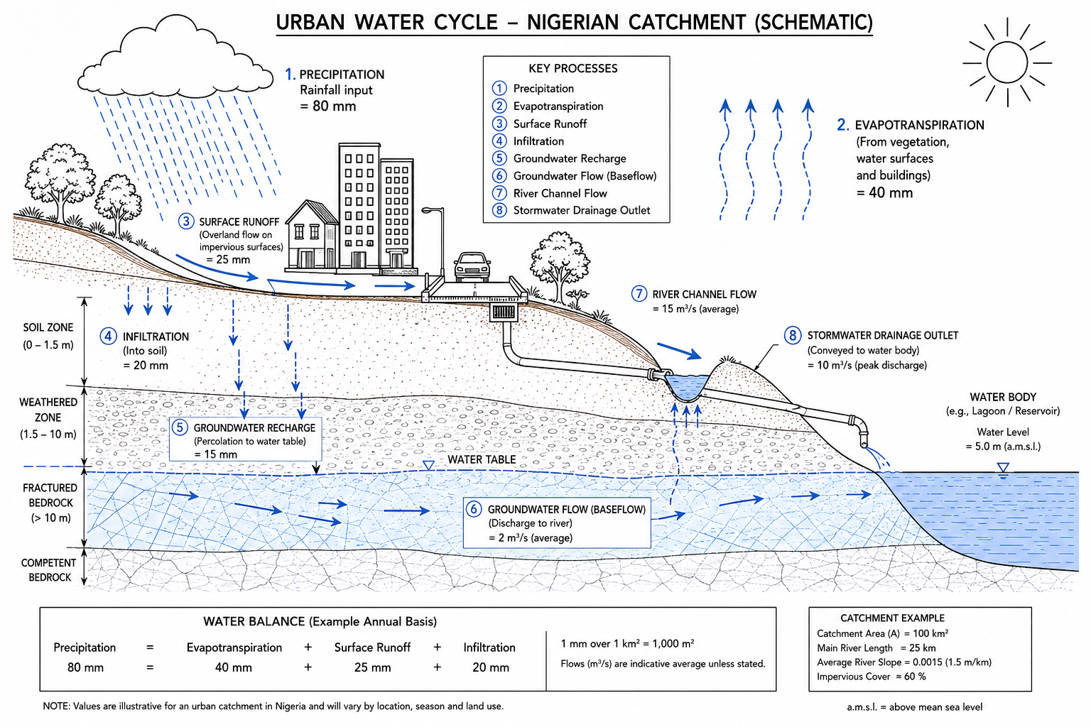
Drive through Warri after a heavy downpour in July. The roads are rivers. Markets are flooded. Properties built within what was once a flood plain are underwater — not because the rain was extraordinary, but because no one modelled the catchment hydrology before laying the first block. Now scale that problem to Lagos Island, Port Harcourt’s low-lying GRA districts, or the floodplains flanking the River Benue in Kogi State. Water resources engineering sits at the intersection of all of it — the discipline that determines how water moves through a landscape, how that movement is measured and modelled, and how infrastructure is designed to manage it safely and sustainably. This guide covers the core concepts, key methods, Nigerian regulatory context, common failure points, and the best practices every civil engineering team should follow before a single metre of drainage channel is excavated.
Water resources guide: Quick Answer
Water resources engineering is the branch of civil engineering concerned with the planning, analysis, design, and management of systems that control and utilise water — including rivers, reservoirs, drainage networks, boreholes, and stormwater channels. In Nigeria, it operates under the Federal Ministry of Water Resources frameworks, relevant NIS standards, and adapted BS codes governing flood routing, hydraulic design, and dam safety.
What Water Resources Engineering Actually Covers
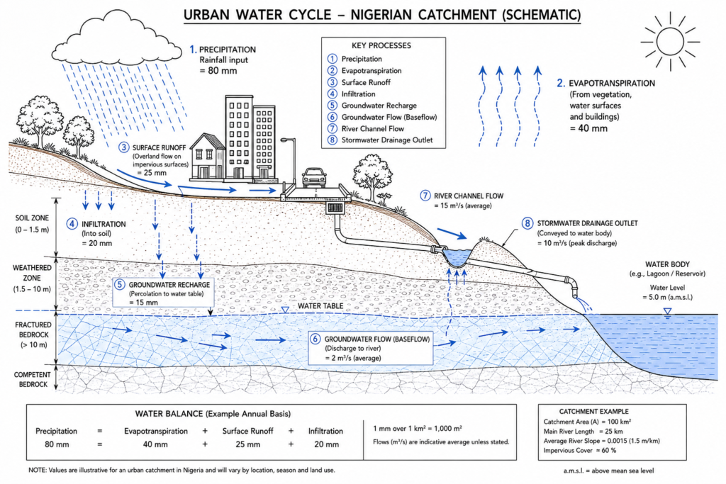
Water resources engineering is the application of fluid mechanics, hydrology, and hydraulics to the design and management of water-related infrastructure. It is not a single narrow specialty — it spans surface water hydrology, groundwater assessment, irrigation systems, flood control works, dam engineering, coastal and estuarine management, urban drainage, and water supply. Understanding where one sub-discipline ends and another begins matters for scoping fees, assigning competence, and managing risk on a project.
In Nigeria, the institutional framework starts at the federal level with the Federal Ministry of Water Resources and Sanitation, which administers the National Water Resources Institute (NWRI) based in Kaduna. River Basin Development Authorities — eleven of them, including the Niger Delta Basin Development Authority and the Hadejia-Jama’are River Basin Development Authority — manage water allocation and infrastructure at the basin scale. State water boards and the Federal Capital Territory Water Board govern urban supply. COREN (the Council for the Regulation of Engineering in Nigeria) requires that water resources work be signed off by a registered engineer under NES categories covering civil and hydraulic engineering.
The distinction between hydrology and hydraulics is worth fixing in your mind early. Hydrology is the science of quantifying water in a catchment — how much rain fell, how much became runoff, how quickly, and where it went. Hydraulics is the engineering of how that water behaves in channels, pipes, culverts, and reservoirs — the physics of flow. A competent water resources engineer works across both. Getting the hydrology wrong produces an underdesigned culvert; getting the hydraulics wrong produces a culvert that fails even when the correct flow is passed through it.
Surface Water vs Groundwater
Nigeria draws on both surface water and groundwater for supply, flood management, and irrigation. Surface water — rivers, lakes, and reservoirs — accounts for the majority of the country’s available freshwater, with major systems including the Niger-Benue confluence, Lake Chad in the north, and the coastal lagoons of the southwest. The challenge is distribution: the Niger Delta receives over 2,000 mm of annual rainfall, while parts of Borno State in the northeast receive less than 300 mm. Any water resources assessment must account for this regional variation before applying design standards.
Groundwater is critical for rural supply and increasingly for urban supply where surface infrastructure has lagged demand. In Lagos, over-extraction of shallow aquifers has caused localised saline intrusion in coastal zones. In Abuja, the weathered basement complex produces low-yield boreholes — typically 0.5 to 2.0 litres per second — that require careful siting using resistivity surveys and hydrogeological mapping before drilling commences. The geotechnical engineering process underpins borehole siting in the same way it underpins foundation selection — subsurface investigation is never optional.
Key Sub-disciplines and Their Interfaces
Flood management works — embankments, retention basins, diversion channels — require structural design input. A flood bund protecting an industrial facility in Port Harcourt must be geotechnically stable as well as hydraulically adequate. Dam design, even for small earth dams used for rural water supply, involves slope stability analysis, filter design, and spillway hydraulics. Urban drainage design connects directly to road engineering, since carriageway gradients and kerb inlet capacity form part of the drainage system. If you are reviewing a road design and the drainage chapter looks thin, treat that as a red flag — more Nigerian roads are damaged by inadequate drainage than by pavement design failures alone. For a closer look at how roads and drainage interact, the roads engineering guide on this site covers the interdependency in detail.
Core Methods in Water Resources Design
Before any channel is sized or any retention pond is laid out, the engineer must characterise the catchment and quantify the design flow. This is where many Nigerian projects go wrong — not in the structural design, but in the hydrological input that drives it.
Rainfall-Runoff Analysis and Return Periods
The design flow for a drainage structure is expressed as a function of a return period — the statistical probability of a given storm being equalled or exceeded in any one year. A 1-in-10-year storm has a 10% chance of occurring in any given year. A 1-in-100-year storm has a 1% chance. The choice of return period is a risk decision, not a purely technical one, and it should be agreed between the engineer and the client with the consequences of under-design clearly documented.
Nigeria lacks the dense, long-period rainfall gauging networks found in Europe. The Nigerian Meteorological Agency (NiMet) operates gauges across the country, but data quality and record length vary significantly by station. Where gauge data is available and covers at least 20 years, a frequency analysis using the Gumbel Extreme Value distribution or the Log-Pearson Type III method can generate design rainfall depths for the required return period. Where gauge data is absent or unreliable, the engineer must apply regional rainfall frequency relationships — the Nigerian standard approach draws on research by NIHSA (the Nigeria Hydrological Services Agency) and the older NERC Flood Studies Report methods adapted for West African conditions.
From design rainfall, runoff is computed. The Rational Method — Q = CiA, where Q is peak flow in m³/s, C is the runoff coefficient, i is rainfall intensity in mm/hr, and A is catchment area in hectares — remains widely used for small urban catchments up to approximately 150 hectares. For larger or more complex catchments, unit hydrograph methods or continuous simulation models such as HEC-HMS are more appropriate. The runoff coefficient C is not a fixed number — it varies with soil type, land cover, and antecedent moisture conditions. Applying C = 0.9 (appropriate for paved urban areas) to a semi-rural catchment in Oyo State where half the land is red laterite clay farmland will overdesign the outlet and underdesign the conveyance system upstream.
Channel and Culvert Hydraulics
Once peak flow is established, the engineer sizes the conveyance system. Open channels are analysed using Manning’s equation: Q = (1/n) × A × R^(2/3) × S^(1/2), where n is Manning’s roughness coefficient, A is the cross-sectional area, R is the hydraulic radius, and S is the channel gradient. Manning’s n for concrete-lined channels typically ranges from 0.013 to 0.016; for earthen channels with moderate vegetation it may rise to 0.035 or higher. Getting n wrong by 20% in an earthen drain produces a meaningful underestimate of required channel dimensions.
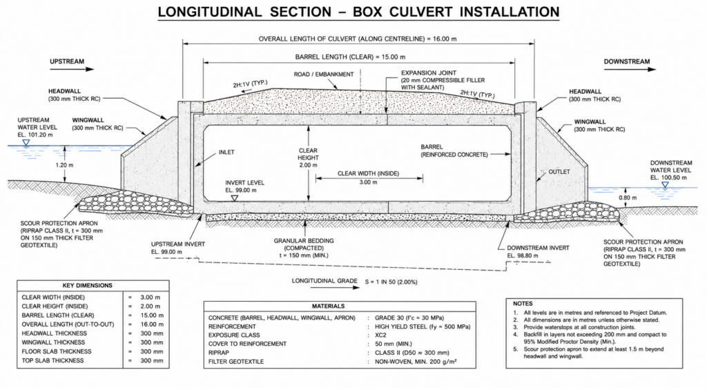
Culverts — the buried pipe or box structures that carry flow beneath roads and railways — are sized using inlet and outlet control analysis. Under inlet control, the culvert capacity is governed by the opening size and the headwater depth. Under outlet control, the downstream tailwater level and the culvert’s friction losses govern capacity. Most culvert failures in Nigeria are not structural — they are hydraulic. The culvert was sized for the road embankment it came with, not for the actual catchment draining to it. A 900 mm diameter pipe under a rural road that was adequate when the surrounding land was forest becomes catastrophically undersized when that land is converted to rooftop and impervious surface.
Water Resources Engineering in the Nigerian Context
Nigeria’s water resources challenges are distinct in their combination of scale, institutional complexity, and climate variability. Annual flooding across the Niger-Benue basin affects hundreds of thousands of people and causes damage that the National Emergency Management Agency (NEMA) estimates in the tens of billions of naira annually. The 2012 floods — triggered by the controlled release from Lagdo Dam in Cameroon combined with exceptional local rainfall — inundated over 30 local government areas in Kogi, Anambra, and Bayelsa states. That event is now a reference point for Nigerian flood risk professionals: the lesson was that transboundary water management cannot be ignored even on a domestic project.
For practising engineers, the regulatory environment spans several instruments. The Water Resources Act (as amended) governs abstraction licensing and water allocation. The National Environmental Standards and Regulations Enforcement Agency (NESREA) enforces effluent discharge standards. State environmental agencies add a second tier of compliance. Any project that involves discharge to a water body, modification of a watercourse, or abstraction above threshold volumes requires permits — and the engineer should confirm the permit pathway early in the design process, not during construction.
On the design standards side, Nigeria has not yet published a comprehensive national hydraulic design manual equivalent to the UK’s CIRIA manuals or South Africa’s Drainage Manual. In practice, most experienced practitioners apply a combination of BS EN ISO standards, the older British Standard BS 8301 for building drainage, and US Army Corps of Engineers hydraulic design guidance where British equivalents are absent. The Federal Ministry of Works Highway Manual provides some drainage design guidance for road projects. Where standards are silent, the engineer must document the basis of design clearly, have it reviewed by a suitably experienced colleague, and record it in the project file.
Lagos presents particular challenges: a low-lying coastal city with a network of tidal lagoons and creeks, a partially formalised drainage system overwhelmed by rapid urbanisation, and a growing incidence of both pluvial flooding (from intense rainfall) and coastal flooding exacerbated by subsidence. Projects in Lagos require tidal level data from the Nigerian Ports Authority (NPA) and careful attention to backwater effects — a culvert that drains freely at low tide may be completely submerged at high tide, effectively functioning as a storage tank rather than a drain. The urban infrastructure challenges in cities like Lagos demand that water resources design is treated as a primary consideration, not an afterthought.
Common Challenges and Failure Points
Most water resources project failures trace back to a small number of repeating mistakes. Recognising them is the first step to avoiding them.
Inadequate site data collection. Commissioning a hydrological study without first establishing what gauge data is available, what its quality is, and what supplementary site measurements are needed is common. A site visit during the dry season that misses the flood mark on an adjacent tree, or a topographic survey that does not extend far enough upstream to capture the full contributing catchment, will undermine even the most sophisticated flood model.
Applying urban runoff coefficients to peri-urban catchments. Rapid development on the edges of Nigerian cities means that a catchment that was 40% impervious when a drainage system was designed may be 80% impervious ten years later. Drainage infrastructure should be designed with projected land use change in mind, not just current conditions. This is especially important in Abuja’s satellite towns — Kuje, Gwagwa, Lugbe — where development is outpacing infrastructure at pace.
Ignoring sediment transport in channel design. An earthen channel designed only for flow capacity, without checking whether the design velocity is sufficient to prevent silting, will be blocked within two to three wet seasons. The minimum self-cleansing velocity for earthen channels carrying sediment-laden flow is typically 0.6 to 0.9 m/s; below this threshold, material drops out of suspension and accumulates in the invert. The opposite problem — excessively high velocities causing scour — is equally common in steep terrain such as the Jos Plateau or the Obudu highlands.
Dam safety compliance gaps on small earth dams. Nigeria has numerous small earth dams constructed for rural water supply and irrigation, many of which pre-date current safety frameworks. The National Dam Safety Commission (NDSC) was established to regulate these structures, but inspection coverage remains limited. Engineers engaged on any work near an existing dam — even for an apparently unrelated project — should establish the dam’s safety status and the consequence classification of its potential failure before proceeding.
Budget pressure on hydrological studies. Clients and contractors frequently ask whether a full hydrological analysis is necessary for a “small” culvert or a “simple” drainage channel. The honest answer is that the cost of an inadequate drainage study is almost always greater than the cost of a proper one — it just falls on a different party, usually the road maintenance budget or downstream property owners. Good cost control in infrastructure projects starts with investing in the right investigations upfront.
Best Practices: A Water Resources Design Checklist
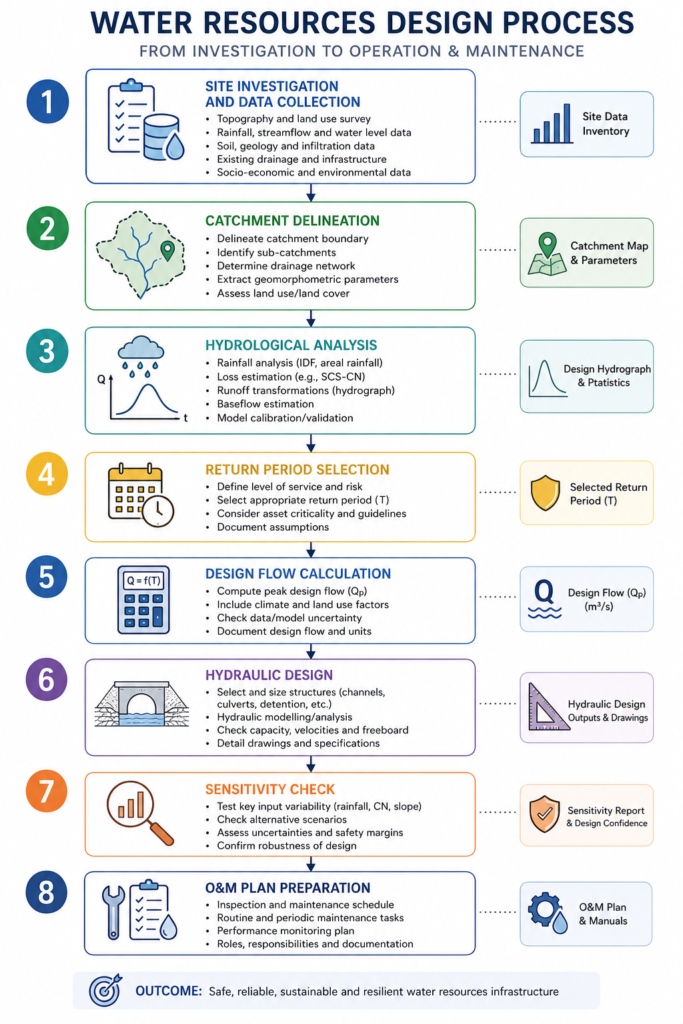
The following steps apply to most water resources design commissions in Nigeria. You may not follow every step on every project — a minor culvert replacement is not the same as a new reservoir — but you should have a clear reason for omitting any item.
- Define the catchment boundary before anything else. Use available topographic data (including SRTM 30m DEM as a minimum; higher-resolution LiDAR or drone survey where the budget allows) to delineate the full contributing area to your structure. Include all upstream sub-catchments, regardless of who owns the land.
- Establish the data baseline. Contact NiMet for daily rainfall records at the nearest long-period gauging station. Contact NIHSA for any river flow records on the receiving water body. Document what you received and the quality assessment you applied to it.
- Agree the design return period with the client in writing. Residential drainage typically uses a 1-in-10-year standard for minor infrastructure; major roads use 1-in-25 to 1-in-50 years; dam spillways use 1-in-1,000 years or the Probable Maximum Flood depending on consequence category. Put the agreed standard in the brief.
- Carry out sensitivity testing on key parameters. Run your flood model with the Manning’s n value at 10% above and below your selected value. Run it with future land use assumptions as well as current conditions. The range of results tells you how sensitive your design is to input uncertainty — and whether you need a larger factor of safety.
- Check freeboard requirements. Open channels should carry the design flow with freeboard to spare — typically 300 mm for minor drains, 600 mm or more for major channels. This is not a conservative excess; it accounts for debris accumulation, weed growth, and the inevitable deviation between as-designed and as-built channel dimensions.
- Design the scour protection.** Culvert outlets, channel transitions, and spillway toe structures require aprons and riprap designed for the maximum exit velocity. Many Nigerian culverts that are hydraulically adequate fail at the outlet because scour undermines the headwall.
- Prepare an operation and maintenance plan. A drainage system that is not maintained will fail. The plan should specify inspection frequency, desilting intervals, vegetation management, and the trigger conditions for emergency response. Build this into the contract documents and the handover package.
For projects involving dam design or significant flood risk, the hydraulic engineering principles that underpin these calculations deserve a dedicated review before design commences.
Frequently Asked Questions About Water Resources
Q: What is water resources engineering in civil engineering?
A: Water resources engineering is the branch of civil engineering that plans, designs, and manages systems for controlling and utilising water. It covers surface water hydrology, stormwater drainage, flood protection works, dam and reservoir design, groundwater assessment, and irrigation infrastructure. In Nigeria, it is regulated through COREN registration requirements and federal water sector legislation administered by the Federal Ministry of Water Resources and Sanitation.
Q: How is the design flood calculated for a drainage project in Nigeria?
A: The design flood is calculated by first determining the rainfall depth for the chosen return period — using NiMet gauge data and a frequency analysis method such as Gumbel or Log-Pearson Type III — and then converting that rainfall to peak runoff using the Rational Method (for catchments under 150 ha) or unit hydrograph methods for larger catchments. The resulting peak flow in m³/s becomes the primary input for sizing channels, culverts, and retention structures. Return period selection — typically 1-in-10 to 1-in-100 years for most infrastructure — should be documented and agreed with the client in writing.
Q: What are the main causes of drainage failure on Nigerian construction projects?
A: The most common causes are: undersized culverts based on current rather than projected land use, incorrect Manning’s roughness values leading to channel overflow, inadequate scour protection at outlets, absence of sediment management planning causing rapid silting, and lack of coordinated maintenance after handover. A secondary but significant cause is the use of outdated or incomplete rainfall data, which produces underestimated design flows. Engaging a qualified water resources engineer at the feasibility stage — rather than after drainage problems have appeared — is consistently the most cost-effective approach.
Q: What is the difference between pluvial flooding and fluvial flooding, and why does it matter for Nigerian cities?
A: Pluvial flooding is caused by intense rainfall overwhelming local drainage — it can occur far from any river. Fluvial flooding is caused by a river overflowing its banks. In cities like Lagos, Ibadan, and Port Harcourt, both types occur, sometimes simultaneously: a heavy downpour saturates the drainage network while a swollen creek backs up into the same low-lying area. The distinction matters for design because the solutions are different — pluvial flooding requires improved local drainage capacity and retention, while fluvial flooding may require embankments, channel widening, or flood warning systems. Many Nigerian urban drainage projects address only one type and are then surprised when the other overwhelms the works.
Q: Does a small earth dam in Nigeria require formal safety assessment?
A: Yes. The National Dam Safety Commission (NDSC) requires that dams above a defined threshold of height and storage volume undergo periodic safety inspections by qualified engineers. Even small dams classified as “low hazard” should be assessed for their potential downstream consequences in the event of failure — this classification can change as development occurs in the flood zone below. Any civil engineering firm engaged on modifications to an existing dam, or on new construction in the vicinity of one, should confirm the current safety status and inspection history with the dam owner and with NDSC before proceeding.
Putting Water Resources Engineering to Work on Your Project
Water resources engineering is not a checkbox discipline. It starts with rainfall and ends with a designed, operable, maintainable system that manages water safely through the life of a structure — accounting for land use change, climate variability, and the institutional realities of Nigeria’s water sector. The gap between “drainage has been provided” and “drainage has been properly designed” is where projects fail, where roads are undermined, where communities flood, and where engineering reputations are lost.
The principles in this guide — catchment-first thinking, rigorous hydrological analysis, code-based hydraulic design, and documented maintenance planning — apply whether you are sizing a 600 mm diameter culvert under a community road in Enugu or designing a 50-million-litre service reservoir for a new urban district in Abuja.
StruviaCore provides water resources and civil engineering consultancy services across Nigeria. If you are at the scoping stage of a drainage, flood management, or water supply project and want to discuss the investigation programme and design approach, reach out to our team through the contact page. We also publish detailed technical guidance across civil and structural disciplines — the foundation design guide is a useful companion read for projects where hydraulic and geotechnical considerations overlap.
Leave a Reply