
Water is the single variable most likely to derail a civil engineering project in Nigeria — and the most consistently underestimated. Across Lagos Island, the Abuja FCT, and the Niger Delta, experienced site engineers have watched well-designed structures fail because the water resources assessment happened too late, too thin, or not at all. Drainage outfalls that back up during the September peak of the wet season. Boreholes sited without aquifer mapping. Retaining walls designed without accounting for artesian pressure in Port Harcourt’s shallow water table. These are not freak occurrences. They are patterns.
A structured water resources checklist does not replace professional judgement — it organises it. This article sets out a field-tested checklist framework covering hydrological assessment, surface drainage, groundwater investigation, water supply planning, and regulatory compliance under Nigerian standards. Whether you are a consulting engineer doing pre-design due diligence, a project manager overseeing a dam or irrigation scheme, or a site engineer starting a residential development in a flood-prone area, this guide gives you a replicable process.
Water Resources Checklist: Quick Answer
A water resources checklist is a structured verification tool used by civil engineers to confirm that all hydrological, hydrogeological, drainage, and water supply considerations have been addressed before and during project execution. It covers site hydrology, groundwater conditions, drainage capacity, water quality, and compliance with Nigerian and international standards such as NIS and BS EN codes.
What a Water Resources Checklist Actually Covers
Water resources engineering is the branch of civil engineering concerned with managing the quantity, quality, timing, and distribution of water in the built and natural environment. In practice, it spans surface hydrology, groundwater systems, drainage infrastructure, water supply and treatment, flood risk assessment, and environmental water management. A water resources checklist is the tool that translates these disciplines into a project-specific verification sequence.
The checklist is not a one-page form. It is a phased document — used at feasibility, at detailed design, pre-construction, and during construction — because the questions you ask at each stage are different. At feasibility, you are asking whether the site is fundamentally viable: is there a flood risk? Is there groundwater at a depth that affects foundation choices? At detailed design, you are confirming that your drainage calculations are calibrated to the correct return period and that your pipe gradients clear the minimum self-cleansing velocity. At construction, you are verifying that as-built positions match design drawings and that settlement pond requirements are met before earthworks begin.
In Nigeria, the checklist must also account for gaps that formal standards do not address: dry-season versus wet-season groundwater fluctuations that can vary by 6–12 metres in basement rock areas of Abuja; the impact of uncontrolled upstream development on downstream flood peaks in fast-urbanising Lagos peri-urban zones; and the practical reality that reticulated water supply is unavailable on most project sites outside major urban centres, making borehole siting a structural — not just service — decision.
For a deeper understanding of the engineering principles underpinning this discipline, the introduction to water resources engineering on this platform covers the foundational concepts in detail.
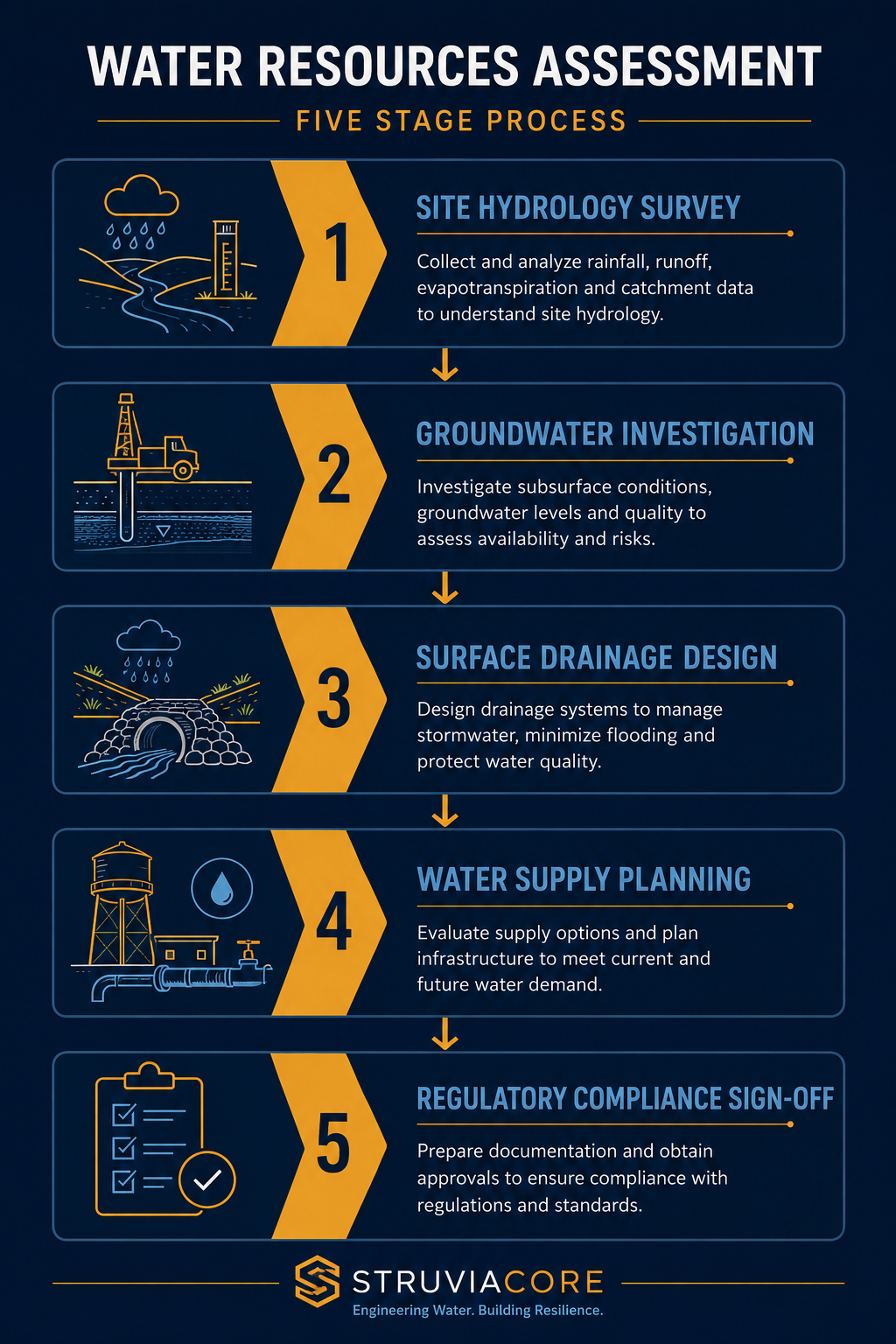
The Five Checklist Domains
A well-structured water resources checklist organises verification tasks into five domains. Each domain generates a set of questions that must be answered — and documented — before the project advances to the next phase.
- Site Hydrology: Catchment delineation, design storm selection, peak discharge calculation, flood frequency analysis.
- Groundwater Assessment: Water table depth and seasonality, aquifer type, borehole yields, contamination risk.
- Surface Drainage: Drainage network design, outfall capacity, erosion control, stormwater detention.
- Water Supply: Source identification, treatment requirements, storage sizing, distribution pressure.
- Regulatory and Environmental Compliance: FMENV permits, State Ministry approvals, environmental impact requirements, effluent standards under NIS 554.

Each domain is elaborated in the sections that follow. The checklist items themselves — formatted for direct field and design-office use — appear in the Best Practices section.
Hydrology and Flood Risk: The Technical Foundation
Every water resources assessment begins with hydrology — the quantitative study of how water moves through a catchment. Getting this wrong at the outset forces expensive redesign downstream, sometimes literally. A drainage outfall sized for a 1-in-10-year storm that receives flows from a 1-in-25-year event will surcharge within the first major rainfall event of its operational life.
Catchment Analysis and Design Storm Selection
The first step is delineating the catchment — the area that drains to the point of interest. In Nigerian urban environments, this is complicated by informal drainage modifications: blocked channels, culverts blocked by solid waste, and new hard surfaces that increase runoff coefficients well above the values assumed in original designs. Use updated topographic data — 1:25,000 NGA (Nigerian Geospatial and Space Agency) sheets as a minimum, supplemented by drone survey where the project warrants it.
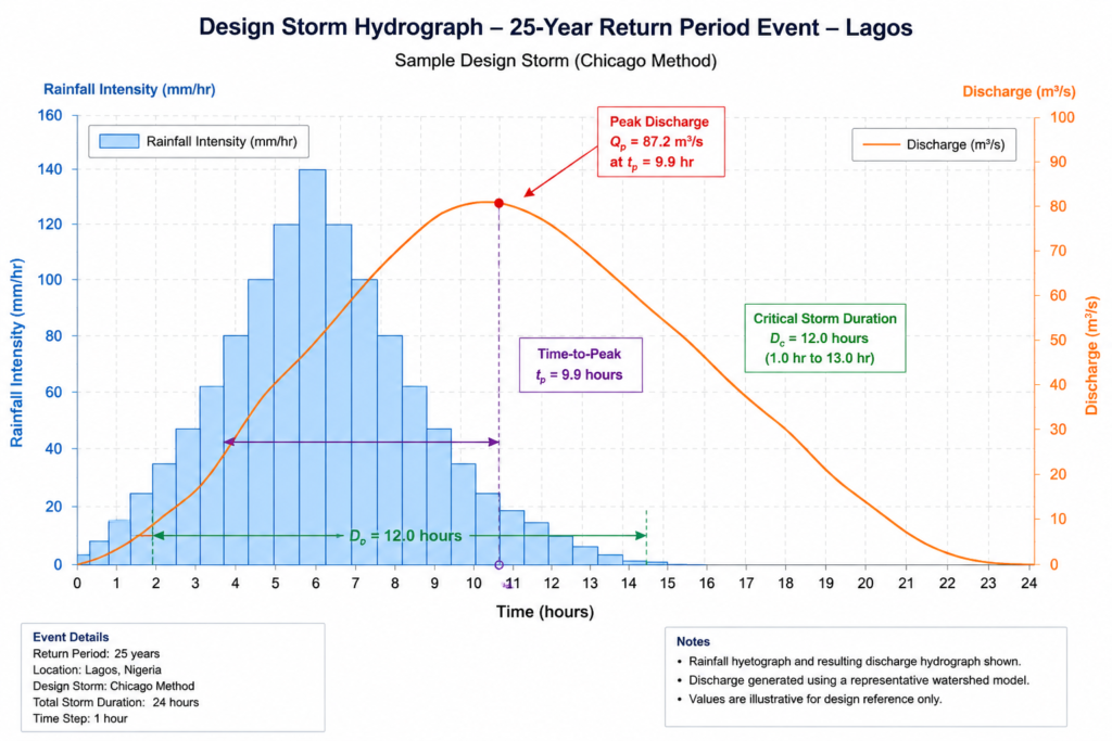
Design storm selection should follow a risk-based approach aligned with the project type. Nigerian practice generally follows the methodology in the Federal Ministry of Works Highway Manual and the principles of BS EN 752 (Drain and Sewer Systems Outside Buildings) as adopted for local conditions. Typical return periods used in Nigerian practice are:
- Minor drainage (road gullies, compound drains): 2–5 year return period
- Major drainage (trunk sewers, primary channels): 10–25 year return period
- Critical infrastructure (dams, major culverts): 100-year return period with a check flood at 1,000 years or PMF (Probable Maximum Flood)
Rainfall data should be sourced from the Nigerian Meteorological Agency (NiMet). Where gauge records are sparse — as is common outside major cities — use regional frequency analysis or regional growth factors derived from published studies on Nigerian rainfall statistics. Do not apply UK or US rainfall atlases to Nigerian sites without calibration; the convective rainfall patterns in the Guinea Savanna and tropical coastal zones produce storm intensities and durations that differ materially from temperate zone data.
Runoff Calculation and Peak Flow Estimation
For small urban catchments under 5 km², the Rational Method (Q = CiA) remains the standard tool. The runoff coefficient C must be determined from actual land-use data — not assumed from a textbook table. A densely packed informal settlement in Lagos Mainland will have a C value of 0.75–0.85; a low-density residential area in Jabi, Abuja may sit at 0.45–0.55. These differences compound significantly when you multiply by catchment area.
For larger or more complex catchments, unit hydrograph methods or rainfall-runoff modelling using tools calibrated with NiMet data are appropriate. Document your methodology, your design storm data, and your C values in a Hydrological Assessment Report — this is a deliverable that clients, local government, and regulatory bodies will request, and its absence causes project delays.
Groundwater Investigation in the Nigerian Context
Nigeria sits across multiple hydrogeological provinces, each with distinct groundwater behaviour. The sedimentary basins of the Niger Delta and the coastal plain sands of Rivers, Delta, and Bayelsa States hold shallow, high-yielding aquifers — but with near-surface water tables that fluctuate seasonally between 0.5 m and 3 m below ground level, directly affecting foundation design, basement construction viability, and septic system siting. The basement complex that underlies much of southwestern Nigeria, the FCT, and the Middle Belt has a fractured aquifer system where borehole yields are highly variable — a successful borehole at 60 m depth and a dry one at 55 m may sit 30 m apart.
Your water resources checklist must include a groundwater investigation protocol proportionate to project scale and type. For a single-dwelling borehole, a geological reconnaissance and review of nearby borehole logs from the state water agency may be adequate. For a multi-building estate, industrial facility, or any project involving basements deeper than 1.5 m, you need a site-specific hydrogeological investigation including trial pits, hand-auger holes, or rotary boreholes with water-level monitoring.
Key parameters to record and document:
- Depth to static water table (SWT) in both dry and wet seasons
- Aquifer type (unconfined, confined, or fractured) and estimated transmissivity
- Borehole yield (litres per hour at sustained pumping, not just instantaneous flow)
- Water quality parameters: pH, total dissolved solids, iron content, nitrate, coliform bacteria — tested against NIS 554:2015 (Nigerian Standard for Drinking Water Quality)
- Potential contamination sources within a 50 m radius: pit latrines, fuel stations, industrial sites
For projects in flood-prone areas, also assess whether shallow groundwater conditions would prevent drainage outfalls from discharging freely — a drainage system designed on the assumption of a 3 m outfall head may be partially or fully submerged during peak wet-season conditions if the water table is not correctly mapped.
The overview of geotechnical engineering principles on this platform covers the interface between groundwater conditions and soil mechanics, including the effect of elevated pore pressures on bearing capacity.
Water Resources Challenges in Nigerian Engineering Practice
The gap between textbook water resources engineering and Nigerian site reality is wide enough to drive a road tanker through. Understanding these challenges is not pessimism — it is the precondition for designing systems that actually work.
Inadequate baseline data. NiMet maintains weather stations at major airports and selected urban centres, but coverage across most of the country remains thin. For projects in rural or semi-urban settings, rainfall records may be limited to 10–15 years, which is insufficient for reliable frequency analysis of rare events. Engineers must document data limitations explicitly in their reports and apply conservative safety factors accordingly.
Rapid urbanisation altering hydrology. Lagos State’s urban footprint has grown faster than its drainage infrastructure. Catchments that were vegetated 20 years ago are now >70% impervious. Drainage systems designed under earlier land-use conditions are systematically undersized. When your project sits in a partially urbanised catchment, use current land-use data — not historical classifications — in your runoff calculations.
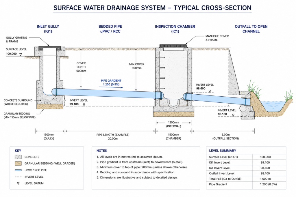
Maintenance gaps. The most well-designed drainage system fails if it is not maintained. Design for maintainability from the start: specify accessible inspection chambers at appropriate intervals (per BS EN 752, at changes in direction, gradient, and diameter, and at maximum 90 m intervals on straight runs), use self-cleansing gradients (minimum 1:150 for 150 mm diameter sewers flowing half-full), and document a maintenance schedule in the project handover file.
Regulatory fragmentation. Water resources regulation in Nigeria involves overlapping jurisdictions: the Federal Ministry of Water Resources, State Ministries of Water Resources, the Hydrological Services Agency (NIHSA), and — for environmental discharge — the Federal Ministry of Environment and State Environmental Agencies. Getting the right permits from the right bodies before construction starts is part of the water resources checklist, not an afterthought.
For projects with a flooding dimension, the hydraulic engineering guide covers open channel flow, culvert design, and flood routing methodologies applied in Nigerian practice.
Water Resources Checklist: Best Practices and Field Verification Steps
The following checklist is structured in four phases. Use it as a live document — items should be signed off with the responsible engineer’s initials and date, not just ticked. Undated sign-offs are useless during a regulatory audit or a dispute.
Phase 1 — Feasibility and Site Assessment
- Obtain and review existing topographic maps at 1:25,000 or larger scale from NGA
- Delineate the project catchment using contour data or digital elevation model (DEM)
- Identify nearest NiMet rainfall gauge and obtain historical rainfall records (minimum 20 years preferred)
- Confirm flood zone status of the site with the State Urban Planning Authority and NIHSA flood risk maps where available
- Conduct a site walkover to observe natural drainage paths, existing watercourses, erosion features, and evidence of past flooding (watermarks on buildings, deposited silt)
- Identify statutory watercourses on or adjacent to the site — riparian rights and development setbacks apply
- Review aerial imagery (Google Earth or drone survey) to map impervious coverage and land-use within the catchment
- Check State Ministry of Water Resources records for any registered boreholes, springs, or licenced abstractions within 500 m
Phase 2 — Hydrological and Hydrogeological Design
- Select design return periods appropriate to project risk category (see Hydrology section above)
- Calculate peak runoff using the Rational Method or unit hydrograph, with documented C values and time of concentration
- Size drainage channels, culverts, and pipes — verify flow velocities are within self-cleansing and erosion-safe limits (typically 0.75–3.0 m/s for concrete-lined channels)
- Confirm outfall conditions: invert level, receiving water level (dry season and wet season), and free-board requirement
- Design stormwater detention or retention where impervious area increase requires attenuation under local authority requirements
- For groundwater-dependent supply: site boreholes away from potential contamination sources per NIS 554 separation criteria
- Specify pump duty (flow rate and total head) for any pumped drainage or water supply system
- Confirm water treatment requirements for potable supply and specify treatment train: sedimentation, filtration, chlorination minimum
- Size water storage tanks: minimum 24-hour storage capacity for residential developments without reliable utility supply
Phase 3 — Regulatory Compliance
- Submit Environmental Impact Assessment (EIA) or Environmental and Social Impact Assessment (ESIA) to FMENV where project scale or type requires it (per EIA Decree No. 86 of 1992)
- Obtain water abstraction permit from State Ministry of Water Resources for any groundwater or surface water abstraction above domestic threshold
- Confirm effluent discharge standards compliance under FMENV National Environmental Standards and Regulations (NESREA) — NIS EN 752 adoption for drainage systems
- File drainage diversion plans with the State Urban Planning and Drainage Authority before any alteration to existing watercourses
- Ensure borehole installation is carried out by a COREN-registered geotechnical or hydrogeological engineering firm and that borehole completion records are filed with the relevant state agency
Phase 4 — Construction and As-Built Verification
- Inspect pipe bedding and backfill — confirm granular bedding to BS EN 1610 Class B minimum for flexible pipes
- Test drainage systems for watertightness before backfilling (hydrostatic or air test per BS EN 1610)
- Verify invert levels against design drawings at each inspection chamber — tolerance ±10 mm
- Confirm borehole yield and water quality testing after completion — do not commission for potable supply without NIS 554 compliance certificates
- Install and test all valves, non-return valves, and pressure gauges before system handover
- Establish erosion protection at all drainage outfalls — rip-rap, gabion baskets, or concrete aprons as specified
- Produce as-built drainage drawings to a minimum scale of 1:500 for submission to the local authority
- Handover package to include: as-built drawings, test certificates, maintenance schedule, emergency contact for drainage system operator
The quality assurance guide for civil engineering projects provides a broader framework for integrating checklist-based verification into your QA/QC management system across all project phases.
Frequently Asked Questions About Water Resources
Q: What is a water resources assessment in civil engineering?
A: A water resources assessment is a systematic investigation of the hydrological and hydrogeological conditions at a project site, covering surface water flow, groundwater depth and quality, flood risk, and the adequacy of water supply. In Nigeria, it informs drainage design, borehole siting, foundation depth decisions, and compliance with FMENV and state water authority requirements. It is produced as a formal technical report and referenced throughout detailed design.
Q: What are the water resources design standards used in Nigeria?
A: Nigerian practice draws primarily on BS EN 752 for drainage systems, BS 8515 for rainwater harvesting, and NIS 554:2015 for drinking water quality. The Federal Ministry of Works Highway Manual provides guidance on road drainage hydrology. For environmental discharge, NESREA regulations and FMENV EIA guidelines apply. COREN registration is required for engineers signing off on water resources designs submitted to regulatory authorities.
Q: How do I determine the design return period for a drainage project in Nigeria?
A: The return period depends on the consequence of failure. Minor compound or road drainage uses a 2–5 year event; major trunk drainage is typically designed for a 10–25 year event; and critical infrastructure such as dams or major culverts serving public roads uses a 100-year flood as the design event, with a check at the Probable Maximum Flood. The selection must be documented and justified in the Hydrological Assessment Report submitted with planning applications.
Q: What are the common causes of drainage failure on Nigerian construction sites?
A: The four most frequent causes are: undersized pipes designed using outdated land-use data (which underestimates impervious area); blocked outfalls due to inadequate clearance between outfall invert and wet-season flood level in the receiving watercourse; poor pipe bedding leading to joint failure and infiltration; and lack of erosion protection at discharge points, which causes undermining of the outfall structure. All four are preventable with a properly executed water resources checklist.
Q: Does a borehole need regulatory approval in Nigeria?
A: Yes. Any groundwater abstraction above domestic quantities requires a permit from the State Ministry of Water Resources. In most states, this covers boreholes for commercial, industrial, or multi-residential use. The installation must be carried out by a qualified drilling contractor, and the completed borehole record — including geological log, casing details, pump test results, and water quality analysis — must be filed with the relevant state agency. Failure to comply can result in enforcement action and project suspension.
Putting the Checklist to Work
The value of a water resources checklist is not in its length — it is in when and how it is used. Too many Nigerian engineering projects treat water resources as a downstream concern, addressed only when a flood, a dry borehole, or a failed drainage system forces the issue. By then, the cost of correction is a multiple of what a structured pre-design assessment would have cost.
Start the checklist at feasibility. Get NiMet rainfall data before you fix your design storm. Delineate your catchment before you size your pipes. Confirm your groundwater conditions before you commit to a basement or a septic system. These are not bureaucratic steps — they are the technical decisions that determine whether your project performs over its 30 or 50-year design life, through every wet season and every dry season the Nigerian climate delivers.
Compliance with the relevant standards — BS EN 752, NIS 554, FMENV EIA requirements — is not the ceiling of good practice. It is the floor. Engineers who apply the full water resources checklist rigorously, document their decisions clearly, and design for maintainability are the ones whose projects hold up. That is what StruviaCore brings to every water resources engagement: structured technical rigour applied at the right phase, not retrofitted after problems emerge.
For project-specific water resources assessments, drainage design, groundwater investigation, or regulatory compliance support, explore StruviaCore’s water resources engineering services or contact our team directly to discuss your project requirements. You can also review the hydraulic engineering case examples for applied illustrations of the principles covered in this art
Leave a Reply