

A drone passes over a construction site in under twenty minutes and delivers a georeferenced point cloud that would have taken a survey crew two days to produce on the ground. That efficiency is real — but so is the invoice that follows. Project managers who adopt drone technology without understanding its full cost structure regularly find themselves over budget by the third month of operation, once licensing renewals, sensor replacements, data processing subscriptions, and operator wages accumulate alongside the headline hardware cost.
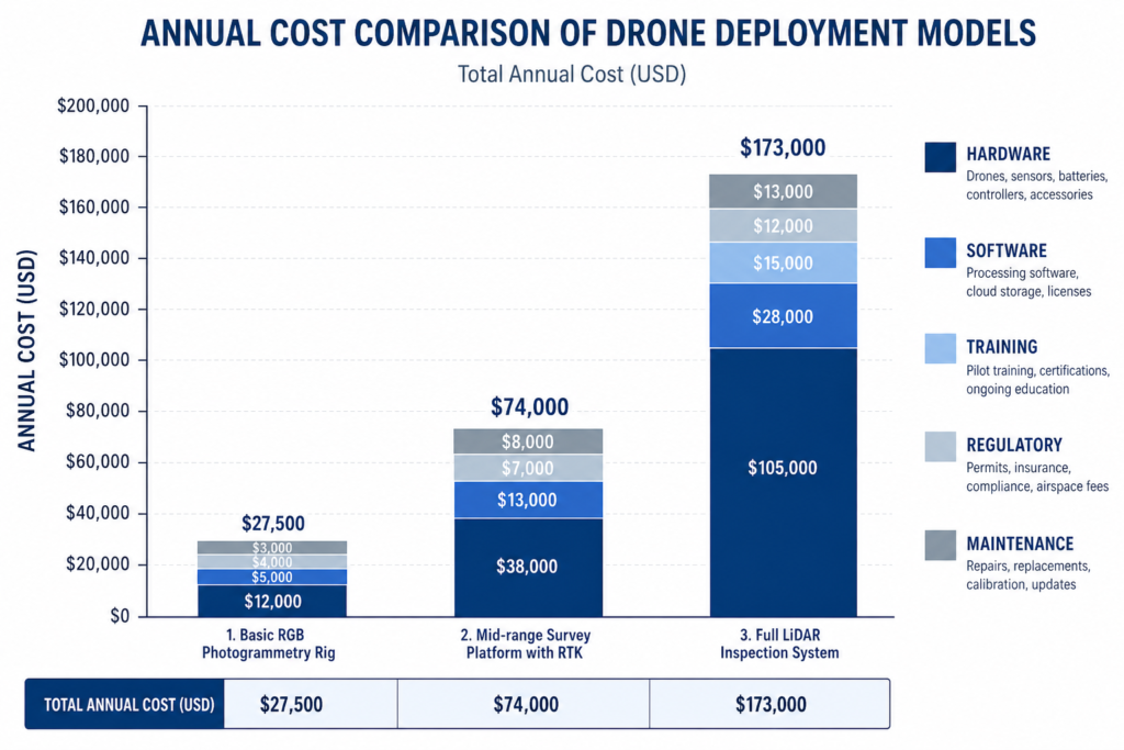
The promise of aerial data capture in civil and structural engineering is well-established. What receives less attention is how drones cost factors interact across hardware, software, regulatory compliance, human resources, and site-specific logistics to produce a total cost of ownership that can differ by a factor of three between a basic photogrammetry setup and a lidar-equipped inspection platform. This article unpacks each cost layer so you can budget with accuracy rather than optimism.
Drones cost factors in construction include hardware purchase price, payload and sensor upgrades, software licensing, operator training and certification, regulatory compliance, insurance, maintenance, and post-flight data processing. Total project costs typically range from modest day-rate charges for basic aerial photography to significant capital investment for lidar survey platforms, depending on payload specification and operational complexity.
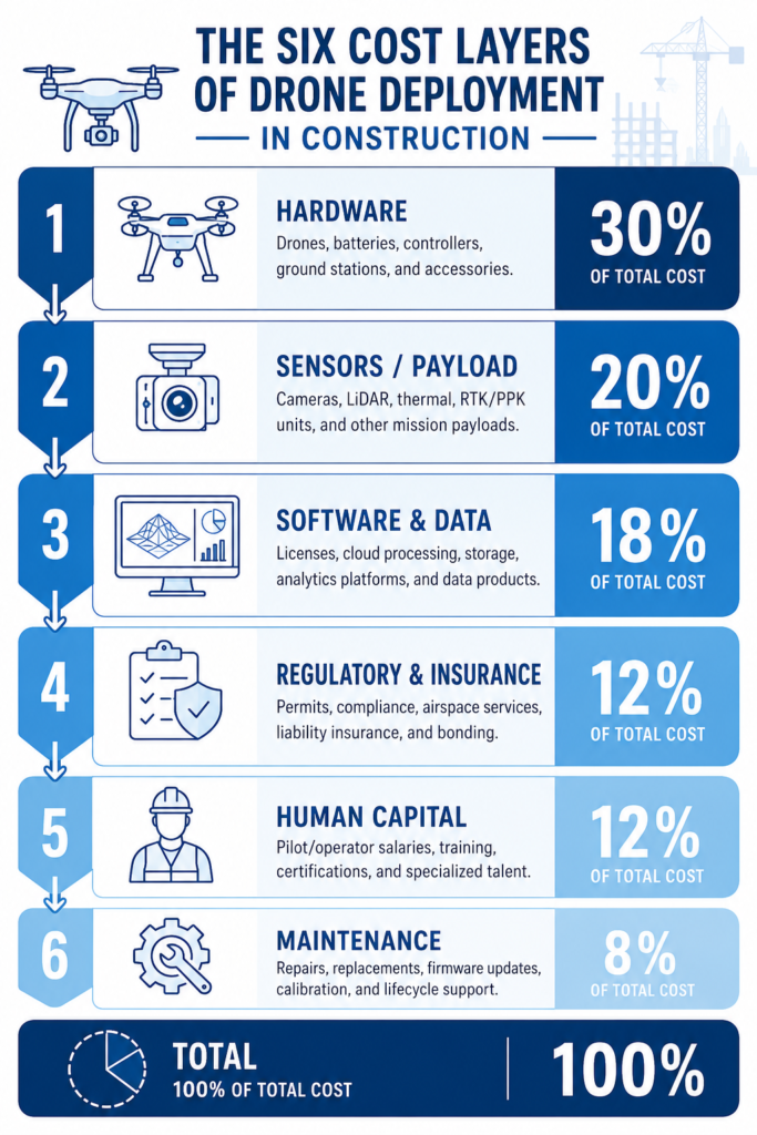
The Hardware Price: More Than the Drone Itself
The airframe is where most people start when they think about drones cost factors, and the price range is genuinely wide. A commercial-grade multirotor platform suitable for construction photogrammetry — the DJI Matrice 350 RTK, for example — currently retails between $6,000 and $9,000 USD. A fixed-wing mapping drone capable of covering 400 hectares per flight can exceed $15,000. At the working end of the market, consumer-grade platforms like the DJI Mavic 3 Enterprise sit around $2,000–$3,500, though their payload limitations constrain what work they can perform on professional sites.
What the airframe price does not include is worth examining carefully.
Payloads and Sensor Costs
The sensor determines what data you capture, and sensors can cost more than the drone itself. A photogrammetry RGB camera suitable for orthophoto and 3D model production typically comes bundled with enterprise platforms or costs $800–$2,500 as an add-on. A survey-grade lidar payload — the type used for detailed structural inspection, cut-and-fill calculations, and corridor mapping — ranges from $10,000 to over $40,000. Multispectral sensors used in environmental impact assessments run $3,000–$6,000.
On construction projects in Nigeria and across sub-Saharan Africa, the import cost of these sensors introduces an additional variable: Customs duties, destination charges, and currency exchange risk against the US dollar or Euro can add 15–30% to the landed cost of imported drone hardware. For a project team procuring equipment locally, this is a non-trivial budget line.
Battery systems are a further hardware cost that is often underestimated. A single intelligent flight battery for a commercial multirotor costs $200–$600 and has a rated cycle life of 200–400 charge cycles before performance degrades. A site operation that flies four hours per day will burn through batteries faster than the rated cycle count suggests, particularly in high-temperature conditions — a real consideration on sites in Lagos, Kano, or Port Harcourt where ambient temperatures regularly exceed 35°C. Budget for a minimum of four to six batteries per platform, plus replacement cycles.
Ground Control Equipment
Accurate drone survey data requires ground control points (GCPs) or real-time kinematic (RTK) corrections, and neither comes free. A base station capable of providing centimetre-level RTK corrections costs $2,000–$5,000. If you subscribe to a network RTK service instead, expect monthly fees of $150–$400 depending on the provider and coverage area. Ground control targets, prisms, and GNSS equipment used to establish and verify GCP coordinates add further cost, particularly where a licensed surveyor must place and record those points to satisfy the requirements of the Office of the Surveyor General or client specification.
Software Licensing and Data Processing Costs
Raw drone data has no engineering value until it is processed. The software stack required to convert flight imagery into deliverable products — orthomosaics, digital terrain models, point clouds, structural inspection reports — is subscription-based, and those subscriptions accumulate.
Photogrammetry processing platforms such as Pix4Dmapper, Agisoft Metashape, or DJI Terra Professional range from $350 to $4,000 per year depending on licence tier. For teams processing large datasets from road corridor surveys or infrastructure inspections, the higher-tier licences with automated processing pipelines are necessary rather than optional. Cloud-based platforms like DroneDeploy or Propeller Aero charge on a per-acre or per-flight-month basis, with annual contracts for construction-scale operations typically falling between $5,000 and $15,000.
Beyond photogrammetry, a project may require:
- Inspection reporting software (e.g. Skydio or Hovermap) for automated structural defect logging — $1,200–$3,600 per year
- GIS integration licences to import point clouds and orthophotos into ArcGIS or QGIS-based workflows — varies by platform
- BIM coordination tools to align drone survey data with design models — an increasingly standard requirement on infrastructure projects where clients mandate Building Information Modelling throughout the project lifecycle
Processing hardware is another underweighted cost. Photogrammetry and lidar processing are computationally intensive. A workstation capable of processing a 2,000-image dataset in under three hours requires a dedicated GPU, 64GB of RAM, and fast SSD storage — a capital cost of $2,000–$5,000 that not every small engineering consultancy has already incurred.
For teams building a digital twin of a structure or site from drone data, the software and compute costs compound further, as the twin must be updated with each new flight cycle to reflect site progress or structural change.
Regulatory Compliance, Airspace Authorisation, and Insurance
In Nigeria, commercial drone operations are regulated by the Nigerian Civil Aviation Authority (NCAA) under the Civil Aviation (Unmanned Aircraft Systems) Regulations 2016 and subsequent directives. Any operator flying commercially — which includes construction survey, infrastructure inspection, and progress monitoring — must hold a Remote Pilot Licence (RPL), and the operating organisation must hold an Unmanned Aircraft Operator Certificate (UAOC). These are not one-time costs.
The NCAA UAOC application and initial certification process carries fees, and the certificate must be renewed annually. Airspace authorisation for flights near airports, federal infrastructure, or restricted zones requires separate approval from the NCAA and potentially the Nigerian Airspace Management Agency (NAMA), which can introduce delays of days to weeks on time-sensitive projects. Failure to obtain the correct authorisation before flight is not a paperwork technicality — NCAA enforcement activity has increased, and operating without certification exposes both the operator and the commissioning client to financial penalties and equipment seizure.
Internationally, the regulatory picture is similar. The UK Civil Aviation Authority mandates a Flyer ID and Operator ID for all commercial drone work, with additional Operational Authorisation required for operations beyond visual line of sight (BVLOS) or near people. In the European Union, the EASA framework categorises operations by risk and mandates specific competency declarations for each category.
Insurance is a distinct but related cost. Professional indemnity and public liability insurance for commercial drone operations typically costs $800–$2,500 per year for a single-operator consultancy, rising with fleet size, operational area, and the complexity of projects flown. Some project owners — particularly government infrastructure clients and international development banks — specify minimum coverage amounts of $2 million or more in their contract requirements, which can push annual premiums higher.
Projects where drone data feeds into structural assessment reports should also consider the professional liability chain carefully. If a drone survey underpins a bearing capacity recommendation or a structural condition rating, the engineer of record carries responsibility for the accuracy of that input data. COREN-registered engineers in Nigeria should verify that their professional indemnity cover extends to digital data-driven assessments as well as traditional field investigation outputs.
Human Capital: Training, Certification, and Operator Costs
A drone is only as productive as the person operating it and the team processing its data. Human capital is a drones cost factor that scales directly with operational ambition — and one that is frequently underestimated in early project budgets.
Pilot training to the standard required for a commercial RPL in Nigeria typically costs $500–$1,500 per candidate, covering ground school, simulator time, and flight assessment. This is the entry-level cost. A pilot trained only to fly has limited value without the skills to plan missions accurately, set ground control points, verify RTK fix quality, and identify data gaps during flight that would require re-flying. Mission planning and quality control competency requires additional structured training, whether through equipment vendor programmes or accredited photogrammetry courses.
Data processing is a separate skill set. A GIS technician or survey engineer capable of running Pix4D or Metashape workflows, validating point cloud accuracy against check points, and producing CAD-ready deliverables earns a market rate that reflects that specialisation. In the Nigerian market, a data processing specialist with drone survey experience commands a salary premium of 20–40% over a conventional draughtsperson.
Day-rate costs for outsourcing drone operations to a specialist contractor — a common approach for firms that want drone deliverables without capital expenditure — typically range from $400 to $1,200 per day for a two-person crew with a survey-grade platform, depending on equipment specification, mobilisation distance, and deliverable type. A lidar inspection survey will carry a higher day rate than a basic orthophoto flight.
The integration of drone outputs into BIM workflows introduces a further human capital requirement: a BIM coordinator or point cloud technician capable of aligning photogrammetry or lidar data with a live design model. This is not a common skill on a typical site team, and outsourcing it adds cost to each project cycle.
Maintenance, Depreciation, and Operational Logistics
The total cost of drone ownership extends well beyond purchase day. A disciplined maintenance programme is not optional on commercial equipment — it is a safety and liability requirement, and the NCAA’s UAOC conditions mandate airworthiness records for all commercial platforms.
Routine maintenance costs for a commercial multirotor include:
- Propeller replacement: $30–$120 per set, recommended every 50–100 flight hours
- Motor servicing: manufacturer-recommended intervals typically fall at 200–400 flight hours; servicing or replacement per motor costs $100–$400
- Firmware and calibration updates: often free but require downtime and specialist access in some cases
- Gimbal and sensor recalibration: recommended after any hard landing or transport incident; costs $150–$500 at an authorised service centre
Depreciation is a real cost even if it does not appear as a line item in an operational budget. A commercial drone platform has a typical working life of three to five years before mechanical wear, component obsolescence, or software support withdrawal makes replacement the more economical option. Spreading the purchase price of a $9,000 platform over four years gives an annual depreciation charge of $2,250 — a figure that belongs in any honest cost-of-operations analysis.
Site logistics add a layer of cost that varies by project. Mobilisation to remote sites — pipeline corridors, transmission line routes, or coastal infrastructure — incurs travel, accommodation, and equipment transport costs that can equal or exceed the day rate for a short-duration deployment. In areas with limited mobile connectivity, real-time data transfer or BVLOS operation is either unavailable or requires specialist radio equipment. High-altitude sites above 3,000 metres see battery performance reductions of 10–20% compared to sea-level rated specifications.
For construction projects using drone data to feed into site monitoring and progress tracking systems, the frequency of flights determines how maintenance intervals interact with operational availability. A platform flying three times per week will reach motor service intervals in roughly 18 months of use — a timeline that should inform both the maintenance budget and the procurement cycle for a replacement platform.
How to Control Drone Costs Without Sacrificing Data Quality
Managing drones cost factors is primarily a specification and procurement discipline. The following practices, applied consistently, keep the cost-to-value ratio of drone deployment on the right side of the ledger.
Match the sensor to the deliverable, not to aspiration. If the project requires a 5 cm resolution orthophoto for site progress documentation, a mid-range RGB platform with RTK delivers that at a fraction of the cost of a lidar system. Reserve the lidar for applications that genuinely require dense point cloud data: structural inspection, cut-and-fill calculation where terrain complexity is high, or corridor mapping where canopy penetration is needed.
Batch flights to reduce mobilisation cost per deliverable. If a site requires monthly progress surveys, coordinate the drone flight schedule to capture all required data — orthophoto, volume estimation, visual inspection — in a single mobilisation. The fixed cost of crew mobilisation, GCP setup, and equipment calibration does not change whether you fly for two hours or six.
Audit your software stack annually. Unused or underutilised licences are common in engineering firms that adopted drone technology incrementally. A cloud processing platform contracted at $12,000 per year that processes 20 flights in 12 months is not delivering value. Evaluate whether a per-project processing model or a lower licence tier better matches your actual throughput.
Invest in training before equipment. A well-trained pilot on a mid-range platform consistently outperforms an untrained operator on a high-specification one. The data quality depends on mission planning, GCP placement accuracy, overlap settings, and in-flight anomaly recognition. These are human skills, not hardware capabilities.
Build maintenance costs into the project budget from day one. Use a simple formula: allocate 12–18% of the annual hardware cost as a maintenance and consumables budget. For a $9,000 platform, that is $1,080–$1,620 per year — a figure that covers routine propeller replacement, one battery replacement cycle, and a mid-year servicing visit.
Verify regulatory status before project mobilisation. NCAA certification delays have grounded drone operations on time-sensitive projects. Confirm UAOC validity, RPL currency, and airspace authorisation as part of the pre-mobilisation checklist — not as an afterthought when the crew is already on site.
Frequently Asked Questions About Drones
Q: What is the average cost of a drone survey for a construction site?
A: A basic aerial photogrammetry survey for a construction site — covering up to 10 hectares with a standard RGB platform and producing an orthophoto and digital surface model — typically costs between $600 and $1,500 per mobilisation when outsourced to a specialist contractor in the Nigerian or West African market. Lidar surveys or large-area corridor mapping campaigns carry significantly higher costs, often $2,500–$6,000 per mobilisation depending on equipment specification and deliverable complexity.
Q: How much does drone pilot certification cost in Nigeria?
A: The NCAA Remote Pilot Licence (RPL) requires ground school training, a theoretical examination, and a flight skills assessment. Total training and assessment costs from accredited providers typically range from ₦250,000 to ₦600,000 (approximately $160–$380 USD at current rates), with the NCAA licence fee payable separately. The Unmanned Aircraft Operator Certificate (UAOC) for a commercial operating organisation carries additional application and annual renewal fees that vary by fleet size and operational scope.
Q: What are the main ongoing costs of operating a commercial drone fleet?
A: Beyond the initial hardware and software investment, the principal ongoing costs are software subscription renewals, battery replacement cycles, insurance premiums, regulatory certificate renewals (RPL and UAOC), propeller and motor servicing, and operator wages or day-rate contractor fees. For a single-platform operation flying regularly, total annual operating costs — excluding depreciation — typically range from $5,000 to $15,000 USD depending on flight frequency and the complexity of data processing required.
Q: What is the difference between drone photogrammetry and drone lidar in terms of cost?
A: Drone photogrammetry uses overlapping RGB images processed into 3D models and orthophotos. It is the lower-cost option: capable platforms start at $2,000–$9,000, and processing software licences run $350–$2,000 per year. Drone lidar uses laser scanning to generate dense point clouds that penetrate vegetation and capture structural geometry with millimetre precision. Lidar payloads alone cost $10,000–$40,000, and the total lidar system cost including processing software typically exceeds $50,000 for a professional setup. The choice should be driven by the deliverable specification, not by the technology itself.
Q: Does drone data need to be signed off by a licensed professional in Nigeria?
A: Where drone survey data underpins engineering decisions — foundation levels, earthworks volumes, structural condition assessments — the output typically requires validation by a COREN-registered engineer or a licensed surveyor, depending on the nature of the deliverable. Raw drone data is not a substitute for a signed engineering report. Project owners and clients should verify that the professional producing the final report carries the relevant registration and that their professional indemnity insurance extends to digitally-derived data sources.
Budgeting for Drones: The Full Cost Picture
Drone technology has changed what a site team can know about a project, and how quickly they can know it. A single morning flight can produce topographic data, progress photography, volumetric estimates, and structural inspection records that previously required multiple specialist mobilisations. The productivity gain is quantifiable and real.
So is the cost structure. The drones cost factors that determine whether a drone programme delivers value — hardware specification, sensor selection, software stack, regulatory compliance, operator competency, maintenance discipline, and data processing capability — each carry a price tag. A project team that accounts for all of them from the outset will find drone deployment straightforward to justify. One that budgets only for the airframe will spend the rest of the project absorbing costs they did not anticipate.
StruviaCore works with project teams to specify, procure, and integrate drone survey capability into civil and structural engineering workflows. Whether you are commissioning a one-off site survey or building an internal drone programme, contact us to discuss how drone technology fits your project budget and technical requirements.
Leave a Reply