

You are driving on a four-lane arterial road when traffic grinds to a halt — not because of an accident, but because the intersection ahead was designed without accounting for peak-hour turning volumes. The signal phase is too short. The lane widths are too narrow for the truck traffic that dominates the corridor. The right-turn bay runs out at 40 vehicles when the queue regularly reaches 65. Every one of those failures was predictable. Every one of them was the outcome of decisions — or the absence of decisions — made at the engineering stage.
Transportation engineering is the branch of civil engineering responsible for preventing exactly those failures. It covers the planning, design, operation, and maintenance of transport systems that move people and goods safely and efficiently. This article breaks down how transportation engineering works in practice: the core disciplines it spans, the technical methods engineers apply, the regulatory framework that governs it, and the common pitfalls that drive up cost and compromise safety on real projects.
Whether you are a project manager scoping a roads contract, a site engineer reviewing pavement drawings, or a developer navigating transport impact assessments, what follows gives you a clear, technical picture of how the discipline operates.
Transportation Engineering: Quick Answer
Transportation engineering is the application of engineering principles to the planning, design, construction, and operation of transport infrastructure — roads, highways, intersections, bridges, rail corridors, airports, and transit systems. Engineers analyse traffic demand, model movement patterns, and design systems that meet safety standards and service level targets within defined cost and environmental constraints.
What Transportation Engineering Actually Covers
Transportation engineering is not simply road building. The discipline spans several interconnected technical domains, each requiring its own specialist knowledge and each influencing the others.
Traffic engineering deals with the movement of vehicles and pedestrians. Engineers collect origin-destination data, count turning movements at junctions, model future traffic growth using tools such as VISSIM or SATURN, and size the road network to serve projected demand without exceeding acceptable levels of congestion. The output is not just a set of lane widths — it is a designed operating regime, including signal timing plans, speed limits, and junction priority arrangements.
Geometric design translates traffic engineering outputs into physical form. Road alignment — both horizontal and vertical — must satisfy minimum stopping sight distance, which under BS 6100 and the UK Design Manual for Roads and Bridges (DMRB) is a function of design speed and gradient. A 100 km/h design speed on a flat road requires a minimum stopping sight distance of 215 m. On a crest curve, that determines the minimum vertical curve length. Get this wrong and you have a geometric hazard baked into the road for the next 50 years.
Pavement engineering determines what the road surface is made of and how thick each structural layer needs to be. This involves soil investigation, California Bearing Ratio (CBR) testing of the subgrade, and calculating design traffic loading in terms of Equivalent Standard Axles (ESAs). A road carrying 30 million ESAs over its design life requires a fundamentally different pavement structure from one carrying 3 million. The UK Highways Agency’s HD 26 and the Transport Research Laboratory’s TRRL Road Note 31 remain standard references for flexible pavement design in many markets. Pavement decisions directly affect whole-life cost — a poorly designed base course can fail in six years rather than 30.
Transport planning sits upstream of the engineering design itself. It addresses mode choice, land use and trip generation, network connectivity, and public transport integration. A new residential development generating 800 trips per day on an existing B-road may require a full Transport Assessment under local planning authority requirements before a single engineering drawing is produced.
All four domains interact. A transport planner’s traffic forecast feeds the traffic engineer’s junction design, which sets the geometric designer’s lane widths, which the pavement engineer uses to calculate loading. Miss a link in that chain and the downstream design is working from wrong inputs.
For an understanding of how structural considerations interact with transport infrastructure — particularly on bridges and elevated sections — see what structural engineering involves and how it applies to infrastructure projects.
The Technical Methods Transportation Engineers Use
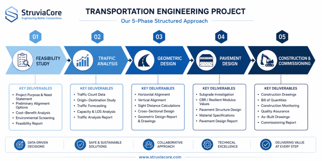
Understanding the workflow of a transportation engineering project gives you a clearer view of where decisions are made and where errors propagate.
Traffic Data Collection and Demand Modelling
Every transportation engineering project starts with data. Manual classified counts at junctions, automatic traffic counters on links, turning movement surveys, and origin-destination surveys using roadside interviews or number plate matching all feed into a base model. The model must be validated against observed conditions — a standard benchmark is that modelled flows should be within 15% of observed flows on individual links and within 10% for the network as a whole, per the DfT’s Traffic Modelling Guidelines.
Future demand is projected using growth factors derived from national or regional traffic forecasts, adjusted for committed development in the area. For major schemes, a four-stage transport model — trip generation, trip distribution, mode split, and assignment — is the norm. The output is a design year traffic matrix that the junction designer uses to size turning lanes and set signal phases.
Junction capacity analysis then follows. For signal-controlled junctions, the industry-standard tool in many markets is LINSIG, which calculates degree of saturation and delay for each lane group. A degree of saturation above 0.90 on any approach indicates the junction will operate over capacity in the design year — a clear signal to redesign before ground is broken.
Geometric and Structural Design of Road Elements
Horizontal alignment design governs how the road curves. Minimum horizontal radius is set by design speed and superelevation. At 80 km/h, a minimum radius of 360 m is required with a maximum superelevation of 7% under DMRB TD 9. Below that radius, the lateral friction demand on a vehicle exceeds the available tyre-to-surface coefficient and the driver loses control.
Vertical alignment governs gradients and crest/sag curves. Maximum gradient on a primary distributor road is typically 8%, though steeper grades are permitted in constrained urban topography. Sight distance on crest curves is calculated using the K-value method: K = L/A, where L is the vertical curve length and A is the algebraic difference in gradients. For a 100 km/h design speed, a minimum K of 100 is required for stopping sight distance.
Cross-section design sets lane widths (typically 3.65 m on rural A-roads, 3.0–3.5 m in constrained urban environments), shoulder widths, verge provision, and drainage cross-fall. A minimum cross-fall of 2.5% is required to drain surface water before it sheets across the carriageway and reduces skid resistance.
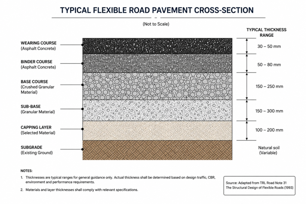
Pavement structural design follows the traffic loading calculation. Subgrade CBR is measured in the field or laboratory; for UK and many international markets, a minimum CBR of 5% is required at formation level, achieved through capping if the natural subgrade is weaker. The pavement structure is then designed using the Analytical Method or catalogue approach in HD 26, selecting bituminous layer thicknesses to keep cumulative damage below the pavement design life threshold.
Bridge and culvert crossings within a road corridor require their own structural design. The loading model — historically BS 5400, now largely superseded by Eurocodes EN 1991-2 for new works — defines the HA and HB vehicle loads the structure must carry. On heavily trafficked routes, a 45-unit HB vehicle (equivalent to a 180-kN axle load) often governs the structural design of deck slabs and main girders. For a deeper look at bridge and structural design principles, the structural engineering guide sets out the key design approaches used on infrastructure projects.
Regulatory Framework and Project Delivery Context
Transportation engineering projects in the USA operate under a layered regulatory environment. At the federal level, the Federal Highway Administration (FHWA) sets standards and administers funding for the National Highway System. State Departments of Transportation (DOTs) publish their own design manuals — CalTrans in California, TxDOT in Texas, NYSDOT in New York — that translate federal policy into project-level requirements. Municipal and county engineers apply local standards for collector and local roads.
Environmental impact sits at the front of the process. Projects above a certain cost threshold or with significant impacts trigger National Environmental Policy Act (NEPA) review, which can require a full Environmental Impact Statement and run for 12–18 months before design approval. Transportation engineers must engage with NEPA early because environmental findings can alter alignment, restrict interchange configurations, or mandate mitigation measures that add cost to the structural design.
At the design level, the American Association of State Highway and Transportation Officials (AASHTO) A Policy on Geometric Design of Highways and Streets — the “Green Book” — sets geometric design standards that DOTs adopt and adapt. For pavement design, the AASHTO Guide for Design of Pavement Structures and the Mechanistic-Empirical Pavement Design Guide (MEPDG) are the primary references.
Project delivery typically follows either Design-Bid-Build (DBB) or Design-Build (DB) procurement. Under DBB, the owner’s engineer produces a complete design before contractors tender — high design certainty but a longer pre-construction programme. Under DB, a contractor is engaged with a scope and performance specification and takes design responsibility — faster to site but requiring more rigorous owner-side quality oversight during design development. For major highway schemes, Public-Private Partnership (P3) structures are increasingly used, where a concessionaire finances, designs, builds, and operates the road over a 30–50 year concession period.
Urban transportation projects increasingly require integration with public transit planning. A new arterial road corridor might need to accommodate bus rapid transit (BRT) lanes, protected cycle infrastructure, and pedestrian crossing improvements simultaneously. This requires early coordination with transit agencies, cycling advocates, and municipal planners — not an afterthought at the detailed design stage. Understanding how urban infrastructure systems interact is addressed in more depth in the urban infrastructure overview.
Common Challenges and Cost Drivers in Transportation Projects
Transportation projects consistently overrun budget and programme. A 2020 meta-analysis of 258 transport infrastructure projects found average cost overruns of 44.7% for road projects and 34.2% for rail, with schedule overruns of 38% on road schemes. The causes are structural, not incidental.
Geotechnical uncertainty is the most frequent source of unbudgeted cost. Ground investigation scope is often cut at feasibility stage to save upfront expenditure, only for soft spots, fill material, or contaminated land to be encountered during construction. A road scheme that assumed a 150 mm capping layer across the whole route may discover 600 mm of soft peat across a 2 km section. That discovery in construction costs five to ten times more to address than it would have in design.
Scope creep in junction design affects urban projects regularly. A transport assessment identifies a need to widen an approach lane. That lane widening requires relocating a utility main. The utility relocation reveals an old brick culvert that must be replaced. The culvert replacement triggers a Section 278 agreement and a revised drainage consent. What began as a lane-widening becomes a six-month programme extension. Accurate early utility search and ground investigation prevent most of this.
Traffic model errors produce undersized or oversized infrastructure. A forecast that overestimates growth by 20% results in wider lanes, longer turn pockets, and larger junctions than needed — capital expenditure that delivers no operational benefit. A forecast that underestimates growth by the same margin delivers a congested junction on day one of opening. Model calibration against observed counts, sensitivity testing across growth scenarios, and peer review of forecast assumptions are non-negotiable quality steps.
Stakeholder and statutory consultee delays are the programme risk most often underestimated. Highways England (or the relevant State DOT) reviews, utility diversions, rail interface agreements, and environmental discharge conditions each carry their own timetable. A project that reaches planning approval in month 18 can still be held at pre-construction for another 12 months waiting for utility agreements and ground investigation licences. Build realistic programme float for each of these.
Cost factors in transportation engineering are examined in more detail in the context of pavement decisions in the pavement engineering guide, which covers whole-life cost analysis and the trade-offs between flexible and rigid pavement options.
Best Practices for Transportation Engineering Projects
These practices reflect what consistently separates projects that deliver on budget and programme from those that do not.
- Commission ground investigation early and scope it properly. A desk study and walkover survey should precede design even at feasibility stage. Trial pits and boreholes at 150 m intervals along the corridor centreline, with laboratory CBR testing at each, give you the data to design the pavement correctly from the start. The cost of a competent GI is typically 0.5–1.5% of construction cost; the cost of discovering bad ground in construction is usually 5–15%.
- Validate your traffic model before using it for design. Run the base model against a counted matrix and verify link flows are within 15% of observed. If the model does not replicate existing conditions, it will not reliably predict future conditions. Fix the base before you start forecasting.
- Carry out junction capacity analysis for the design year, not the opening year. A junction that operates at 0.85 degree of saturation at opening may be at 1.05 by year 10 if traffic growth assumptions were conservative. Design to the end of the assessment period — typically 15–20 years from opening for urban junctions, 30 years for major highway schemes.
- Check horizontal and vertical sight distance at every decision point. Prepare sight line drawings for every junction, access, and pedestrian crossing. Vegetation and boundary structures are as much a sight distance hazard as geometry — require them to be shown on the drawings and assessed.
- Specify skid resistance by category of road use. HD 36 categorises road sites by accident risk and traffic speed. A motorway lane has a minimum investigatory level of 0.45 SFC. A pedestrian crossing on a 50 mph road requires 0.60 SFC. Specifying the right aggregate polished stone value (PSV) in the pavement specification is a safety-critical decision, not a surface-dressing detail.
- Engage statutory consultees at RIBA Stage 2 (or equivalent), not at submission. Highways authorities, utility companies, and environment agencies all have programme-critical review periods. The earlier you give them draft information, the earlier you get substantive comments. Submitting for discharge of conditions without pre-consultation is a reliable way to add six months to your programme.
- Build the drainage design before the road design is fixed. Drainage cross-fall, outfall locations, and attenuation requirements affect both alignment and level. Projects that treat drainage as a post-design task consistently discover conflicts with utilities, property boundaries, and junction geometries that require costly redesign.

For projects involving rail infrastructure or multi-modal interchange, the design complexity increases significantly. The rail infrastructure guide covers the technical requirements specific to rail alignment, track geometry, and station design that differ from standard highway engineering practice.
Frequently Asked Questions About Transportation Engineering
Q: What is transportation engineering in civil engineering?
A: Transportation engineering is the sub-discipline of civil engineering that plans, designs, constructs, and manages systems for moving people and goods. It covers road geometry, traffic signal design, pavement structure, bridge loading, public transit infrastructure, and transport modelling. Transportation engineers work at every scale, from optimising a single junction to planning a 200 km highway corridor.
Q: How does traffic modelling work in transportation engineering?
A: Traffic modelling begins with observed count data — classified junction turning counts, link flows, and origin-destination surveys. Engineers build a calibrated base model that replicates existing conditions, then apply growth factors and committed development trips to project future demand. The design year model is used to test junction layouts, assess capacity, and generate signal timing plans. Industry-standard tools include VISSIM for microsimulation, SATURN for strategic assignment, and LINSIG for signal-controlled junction analysis.
Q: What is the difference between transportation engineering and traffic engineering?
A: Traffic engineering is a subset of transportation engineering focused specifically on the movement of vehicles and pedestrians — junction design, signal control, road markings, and speed management. Transportation engineering is the broader discipline that includes traffic engineering alongside pavement design, geometric road design, bridge engineering, transit planning, and transport policy. A transportation engineer may specialise in traffic, or may work across all of these domains on major infrastructure projects.
Q: How much does transportation engineering consultancy cost?
A: Fees vary by project scale and complexity. For a standalone transport assessment supporting a planning application, expect fees in the range of $15,000–$60,000 depending on the size of the development and the complexity of the highway network. A full transportation engineering service for a major road scheme — including preliminary design, detailed design, and construction support — typically runs between 8% and 12% of the construction contract value. Early ground investigation and model calibration reduce the risk of costly design changes, making upfront investment in thorough technical work commercially rational.
Q: What are the main types of road pavement used in transportation engineering?
A: Road pavements fall into two primary categories. Flexible pavements use bituminous materials in multiple layers — wearing course, binder course, and base — over a granular sub-base and prepared subgrade. They distribute load gradually and are designed for a specific traffic loading in Equivalent Standard Axles. Rigid pavements use a concrete slab that spans over the subgrade, distributing load across a wider area. Rigid pavements typically have lower maintenance costs over their design life but higher initial construction cost. Composite pavements combine both systems. The choice between them depends on traffic volume, subgrade CBR, whole-life cost analysis, and available materials.
Transportation Engineering Delivers Safe, Efficient Infrastructure — When Done Right
Transportation engineering is where movement meets physics, economics, and public safety. When the discipline is applied correctly — with sound traffic data, rigorous geometric design, properly specified pavement structures, and early engagement with the regulatory environment — the result is infrastructure that serves its users safely for 30 years or more. When it is applied poorly, the consequences range from congested junctions and premature pavement failure to geometric hazards that produce predictable, preventable accidents.
The common thread in failed transportation projects is not lack of engineering knowledge — it is compressed timescales, inadequate ground investigation, and traffic models that were never properly validated. None of those failures are inevitable. They are choices made under commercial pressure, and they have engineering solutions.
StruviaCore provides transportation engineering consultancy across road design, traffic modelling, pavement assessment, and transport planning. If you are scoping a roads project, navigating a planning transport assessment, or reviewing the technical quality of an existing design, explore our transportation engineering services or contact our team directly to discuss your project requirements.
Leave a Reply