
A drainage engineer on a mixed-use development in Dubai once described his project’s first monsoon season as “instructive.” The site flooded in under forty minutes despite a drainage network that looked perfectly adequate on paper. The wadi catchment upstream had not been modelled accurately. The soil infiltration rates used in the design came from a temperate-climate textbook. The outlet structure was sized for average rainfall, not the 1-in-50-year event that the UAE’s arid climate can deliver with almost no warning. That project taught everyone involved exactly what hydraulic engineering challenges look like when they are underestimated.
This article covers the principal hydraulic engineering challenges facing civil and structural practitioners in the UAE — from flash flood modelling and groundwater interaction to coastal hydraulics, regulatory compliance, and the data gaps that haunt every design submission. Whether you are a site engineer managing a drainage submission or a project manager reviewing a hydraulic report, understanding these challenges at a technical level will save you time, money, and reputational risk.
Hydraulic Engineering Challenges: Quick Answer
Hydraulic engineering challenges are the technical, environmental, and regulatory obstacles engineers face when designing systems that manage the movement, distribution, and control of water. In the UAE, the primary challenges are flash flood risk in wadi catchments, saline groundwater interaction, coastal erosion dynamics, insufficient hydrological data, and the need to design for extreme rainfall return periods in an otherwise arid climate.
What Hydraulic Engineering Actually Involves in the UAE Context
Hydraulic engineering is the branch of civil engineering concerned with the flow and conveyance of water — through channels, pipes, coastal structures, retention basins, and natural watercourses. In most parts of the world, hydraulic engineers work with relatively predictable rainfall patterns and well-documented river systems. In the UAE, neither condition applies with any comfort.
The country sits in a hyper-arid zone where mean annual rainfall in Abu Dhabi is approximately 75mm, yet individual storm events can deliver 80–100mm in under two hours. These convective storms are spatially erratic and temporally concentrated, which makes standard statistical frequency analysis — the backbone of hydraulic design in wetter climates — considerably less reliable. A 100-year return period event in Dubai is not a smooth statistical extrapolation; it is a physically plausible extreme that the historical record may have captured only once or twice, or perhaps not at all.
This statistical thinness is compounded by the physiographic character of the UAE. The Hajar Mountains in the east and the flat gravelly plains that slope toward the Gulf and the Arabian Sea create a landscape in which runoff concentrates rapidly in ephemeral watercourses — wadis — and then fans out across alluvial plains that are now, in many cases, occupied by roads, residential communities, and industrial zones. Understanding how water moves across this terrain requires specialised hydrological modelling, not generic drainage design.
The Role of Wadis in UAE Hydraulic Design
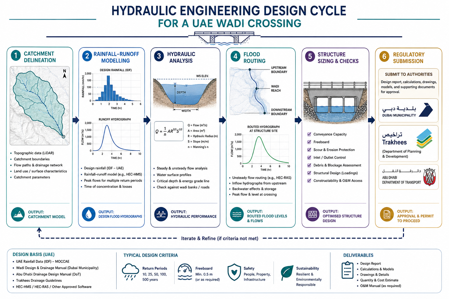
A wadi is a dry riverbed that carries water only during and immediately after rainfall. From a hydraulic standpoint, wadis are intermittent high-energy systems. When a storm hits the Hajar Mountains, runoff can reach a wadi crossing 20 to 30 kilometres away within two to three hours, carrying sediment loads that would overwhelm a culvert sized purely for water discharge. The 2015 and 2020 flooding events in Ras Al Khaimah and Fujairah demonstrated clearly that wadi crossing designs that ignore sediment transport and debris blockage will fail when the design event arrives.
Any project within or adjacent to a wadi setback zone — typically 100 to 200 metres from the wadi centreline, though this varies by emirate — must produce a site-specific hydrological and hydraulic study. The study must define the peak discharge for the 25-year, 50-year, and 100-year return periods, and the design structure must accommodate the Q100 event with adequate freeboard. For road crossings, the Abu Dhabi Department of Transport mandates that the soffit of a culvert sits above the Q50 water surface elevation, with full flood containment to Q100 level.
For a practitioner not previously working in the Gulf, the most common underestimation is the time of concentration. Because wadi catchments are steep and largely impervious — bare rock and gravelly desert soil — rainfall-runoff conversion rates are high and the time of concentration is short. Using the Kirpich or NRCS methods calibrated for vegetated catchments will produce unconservative results. Geotechnical conditions in the UAE, including shallow rock and variable alluvial deposits, also affect infiltration assumptions that feed directly into runoff calculations.
Key Technical Challenges in Hydraulic Engineering Projects
The hydraulic engineering challenges UAE practitioners encounter are not abstract. They appear in specific, predictable ways across project types. Understanding them in advance allows you to build the right scope of investigation, allocate appropriate budget, and avoid the design reviews and resubmissions that erode programme on fast-track developments.
Rainfall Data Gaps and Return Period Uncertainty
The UAE has a relatively short continuous rainfall record. The longest gauged records in the country extend back to the late 1960s, and many rain gauge networks were sparse until the 1990s expansion of the UAE Meteorological Service infrastructure. For a design requiring confidence in the 1-in-100-year rainfall intensity-duration-frequency (IDF) curve, fifty to sixty years of data is borderline inadequate by the standards of ISO 5168 or WMO guidelines on hydrological data adequacy.
The practical consequence is that IDF curves for UAE cities carry meaningful uncertainty bands that designers rarely acknowledge explicitly. Dubai Municipality and Abu Dhabi City Municipality both publish adopted IDF curves for use in drainage submissions, and these represent the accepted regulatory standard. Using any other IDF source requires explicit approval and justification. However, even the adopted curves are extrapolations into low-probability territory using distributions — typically Gumbel or Log-Pearson Type III — fitted to limited data. A conservative design will apply a sensitivity check at ±15–20% of the adopted rainfall depths.
Groundwater and Saline Intrusion
The UAE’s groundwater table is shallow in coastal zones and around wadis, and the water is often saline or brackish. This creates a dual problem for hydraulic structures: hydrostatic uplift on below-grade components, and aggressive chemical attack on concrete and steel. A drainage sump or detention basin in Abu Dhabi’s coastal fringe may experience groundwater at 1.0–1.5m below ground level, with chloride concentrations exceeding 4,000 mg/L. Concrete in such conditions requires a minimum cement content of 400 kg/m³, a water-to-cement ratio below 0.40, and sulphate-resistant cement per BS 8500 Part 1 exposure class XS2 or XS3, depending on tidal influence.
Beyond structural durability, high groundwater also limits the effectiveness of infiltration-based sustainable urban drainage (SuDS) components. Soakaways and permeable paving — standard tools in UK drainage design per CIRIA C753 — function poorly when the groundwater table sits within 500mm of the soakaway base. UAE projects in low-lying coastal areas therefore rely almost entirely on piped conveyance and pumped outfalls, which increases capital cost and introduces ongoing maintenance obligations. Effective water resources management in these zones requires integration of stormwater planning with groundwater monitoring from the earliest project stages.
Coastal Hydraulics and Shoreline Dynamics
The UAE has over 1,300 kilometres of coastline, and a significant proportion of current and planned development sits on reclaimed or near-shore land. Coastal hydraulic engineering here must address wave loading on seawalls and revetments, littoral drift and shoreline erosion, tidal range and storm surge, and the interference between man-made coastal structures and natural sediment transport pathways.
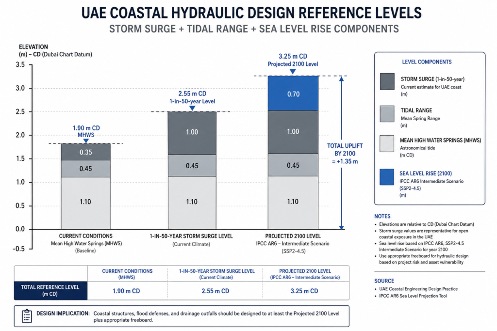
The Arabian Gulf has a small tidal range — approximately 1.0 to 1.8 metres at Dubai and Abu Dhabi — but storm surges during Shamal wind events can add 0.5 to 1.0 metres above predicted tide. For coastal infrastructure with a design life of 50 years or more, sea level rise projections under IPCC AR6 scenarios (0.3 to 0.6 metres by 2100 under intermediate pathways) must be incorporated into the hydraulic design datum. Many legacy coastal structures in the UAE were designed without this consideration, and retrofit costs are now being realised. The EAD (Environment Agency Abu Dhabi) now requires sea level rise allowances in coastal development submissions within Abu Dhabi emirate.
Regulatory and Institutional Landscape for Hydraulic Submissions in the UAE
One of the less-discussed hydraulic engineering challenges is navigating a regulatory environment that varies by emirate, by project type, and — in some cases — by free zone jurisdiction. There is no single UAE-wide hydraulic engineering code equivalent to BS EN 752 for drainage or the Eurocode suite for structural design. Instead, practitioners work with a patchwork of municipal standards, authority guidelines, and adopted international codes.
In Dubai, major drainage submissions go to Dubai Municipality (DM) Engineering Department. The DM Green Building Regulations and its Stormwater Management guidelines provide the baseline requirements, including minimum pipe design standards, road drainage cross-fall requirements, and sub-catchment sizing methods. For development within Dubai South, the free zone authority has its own drainage approval process. For Jebel Ali Free Zone and certain other areas, Trakhees functions as the relevant approval authority and has its own submission format requirements.
In Abu Dhabi, the Abu Dhabi City Municipality (ADM) and the Department of Energy (DoE, for certain utility-related drainage) govern most drainage approvals, while the Department of Transport (DoT) handles road drainage on public highways. The Abu Dhabi Urban Planning Council (now integrated within Abu Dhabi City) also has requirements relating to wadi buffer zones and flood risk mapping under the Abu Dhabi 2040 Plan.
For hydraulic engineers working across multiple emirates — which is common on large infrastructure programmes — building a regulatory matrix at the outset of a project prevents submission failures. A drainage design produced to Dubai Municipality standards will not necessarily satisfy ADM requirements without modification. Submissions also increasingly require hydraulic modelling evidence from software accepted by the authority, typically HEC-RAS, MIKE FLOOD, or Infoworks ICM. Submissions produced using simplified manual methods — rational formula plus Manning’s equation — are accepted only for minor works below defined thresholds. The full hydraulic engineering process from hydrological analysis to regulatory submission is covered in depth in our companion guide.
Common Mistakes That Generate Cost Overruns and Design Failures
Hydraulic engineering mistakes in the UAE tend to cluster around a small number of recurring errors. Understanding them is half the battle.
The first is using inappropriate rainfall data. Applying IDF curves from a neighbouring emirate without checking whether the curves have been regionally calibrated is a common early error on fast-tracked projects. The rainfall intensity at 30-minute duration for a 50-year return period can vary by 15–25% between Abu Dhabi and Sharjah simply due to orographic differences.
The second is underestimating sediment. A hydraulic model that routes floodwater accurately but ignores bedload transport will overestimate culvert capacity. In wadi systems, sediment deposition during a major event can reduce a culvert’s effective opening area by 30–50% within hours. The UAE Ministry of Infrastructure Development’s road drainage manuals require sediment trap sizing upstream of all culverts on wadi crossings, and this is not optional.
The third is neglecting outfall constraints. A stormwater network sized correctly for the design catchment may still fail if the outfall — whether to a wadi, the sea, or a retention basin — cannot accept the peak discharge without backing up into the network. Outfall hydraulics must be confirmed before internal network design is finalised, not after.
The fourth is inadequate freeboard. UAE drainage authorities typically require a minimum 300mm freeboard above the design flood level for open channels and 150mm for piped systems at access chambers. Projects that design exactly to the flood level with no margin leave no tolerance for model uncertainty or construction inaccuracy.
Cost overruns on hydraulic works most commonly arise from late discovery of these issues during detailed design or construction. A hydrogeological investigation missed at feasibility stage can result in a completely redesigned outfall system at RIBA Stage 4. The remedial cost is rarely less than five times what the investigation would have cost. Structured risk management in hydraulic projects should specifically identify hydrological and geotechnical data gaps as key risks from Stage 1 onwards.
Best Practices for Managing Hydraulic Engineering Challenges in the UAE
The following practices reflect what competent hydraulic engineering teams apply consistently on UAE infrastructure and development projects. They are not theoretical — they come from lessons learned across road drainage, wadi management, coastal protection, and urban flood risk assessment projects across the Emirates.
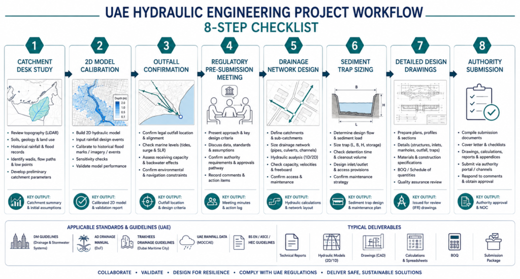
Commission a desk-based hydrological study before feasibility design is complete. This study should delineate all catchments draining to the site, identify wadi setback zones, review available rainfall data quality, and flag any upstream infrastructure (dams, check dams, bypass channels) that would modify the flood hydrograph. In the UAE, the Ministry of Energy and Infrastructure maintains records of hydraulic infrastructure that can significantly alter flood risk on development sites. Missing a check dam 8km upstream has derailed more than one design.
Use a calibrated 2D hydraulic model for any site with complex topography or within a flood-prone zone. HEC-RAS 2D and MIKE FLOOD are both accepted by UAE municipal authorities. A 2D model captures floodplain dynamics that a 1D channel model will miss — including flow paths across roads, between buildings, and around infrastructure — and provides the depth-velocity product data that risk assessment frameworks require.
Confirm your outfall first. Before sizing a single pipe or channel in your drainage network, establish what the outfall can accept. If the outfall is a wadi, determine the Q100 water surface elevation at the confluence point. If it is the sea, establish the design still water level including storm surge. If it is a retention basin, confirm available volume and emptying mechanism. The internal network design follows from outfall constraints, not the other way around.
Engage early with the approval authority. Dubai Municipality, ADM, and Trakhees all allow pre-submission meetings for complex hydraulic schemes. A thirty-minute meeting at the start of detailed design — to confirm acceptable software, submission format, drainage strategy, and design return periods — can prevent a full resubmission cycle that adds eight to twelve weeks to programme.
Design for sediment from day one. Size sediment traps, include access for mechanical cleaning, and apply a blockage allowance to all culverts in wadi catchments. The blockage factor recommended in the UAE Road Design Manual ranges from 1.2 to 1.5 depending on upstream catchment sediment yield. Applying this factor at design stage costs nothing; retrofitting a larger culvert after the road has been built is expensive and disruptive.
Sound foundation design for hydraulic structures — particularly culvert headwalls, pump station wet wells, and coastal revetment toe beams — requires the same early geotechnical engagement. Hydraulic and geotechnical investigations should run in parallel, not sequentially. The soil bearing capacity, groundwater level, and corrosivity data generated by a geotechnical investigation directly feed into hydraulic structure design.
Frequently Asked Questions About Hydraulic Engineering
Q: What is hydraulic engineering in civil engineering?
A: Hydraulic engineering is the sub-discipline of civil engineering that deals with the physical behaviour of water in motion and at rest — including rivers, drainage networks, coastal systems, dams, and water supply infrastructure. In practice, it covers hydrological analysis, channel and pipe design, flood modelling, coastal protection, and stormwater management. In the UAE context, it also encompasses wadi management and the specific challenges of designing for short-duration, high-intensity rainfall events in an arid environment.
Q: What are the main hydraulic engineering challenges in the UAE?
A: The primary challenges are: short and spatially variable rainfall records that limit IDF curve confidence; high-energy wadi systems carrying both water and heavy sediment loads; shallow saline groundwater that limits infiltration-based drainage and drives up structural durability requirements; coastal hydraulic complexity including storm surge and sea level rise; and a fragmented regulatory landscape with different approval requirements across Dubai, Abu Dhabi, Sharjah, and free zone authorities.
Q: What return period should I use for drainage design in Dubai?
A: Dubai Municipality requires stormwater drainage networks serving residential areas to handle the 10-year return period storm without surcharge, and the 50-year event without surface flooding above defined depths. Wadi crossings and major outfall structures are typically designed to the 100-year return period (Q100). Specific requirements vary by project type and location, and the DM Engineering Department should be consulted for current standards on any major scheme.
Q: How does sediment affect hydraulic engineering design in the UAE?
A: Sediment is one of the most underestimated variables in UAE wadi hydraulics. During a design storm, bedload sediment concentrations in wadi flows can reach 5–15% by volume. This reduces effective culvert capacity, can block outlets within hours, and dramatically increases scour risk at bridge piers and culvert aprons. UAE design standards require sediment traps upstream of culverts, blockage factors applied to hydraulic capacity calculations, and energy dissipation structures at culvert outlets to prevent downstream scour.
Q: What software is accepted for hydraulic modelling submissions in the UAE?
A: The most widely accepted hydraulic modelling packages across UAE municipal authorities are HEC-RAS (1D and 2D), MIKE FLOOD, and Infoworks ICM for urban drainage. SWMM is accepted by some authorities for stormwater network analysis. XP-SWMM and other packages may be accepted on a case-by-case basis with prior authority agreement. For coastal hydraulic modelling, MIKE 21 and SWAN (for wave modelling) are standard. Always confirm software acceptability with the relevant authority before committing to a modelling approach.
Addressing Hydraulic Engineering Challenges Requires More Than Good Software
The hydraulic engineering challenges described in this article are solvable. UAE practitioners have been designing successful drainage systems, wadi crossings, and coastal structures for decades. But the projects that succeed do so because of disciplined data collection, early regulatory engagement, conservative design assumptions, and genuine understanding of the local hydrological environment — not because the engineer ran the right software.
Flash floods do not respect designs that treat UAE rainfall as a minor inconvenience. Sediment does not disappear because it was not included in a model. Groundwater does not recede because the specification assumed drier conditions. The cost of addressing these realities at the investigation stage is a fraction of the cost of addressing them during construction or, worse, after a structure fails.
At StruviaCore, our hydraulic engineering team works across drainage masterplanning, wadi hydraulics, flood risk assessment, and coastal structure design on projects across the UAE. If you are facing hydraulic engineering challenges on a current or upcoming project — whether a masterplan submission, a wadi crossing design, or a coastal development — contact us to discuss how we can help you navigate both the technical and regulatory demands. You can also explore our introduction to hydraulic engineering as a starting point for understanding the full scope of the discipline.
Leave a Reply