
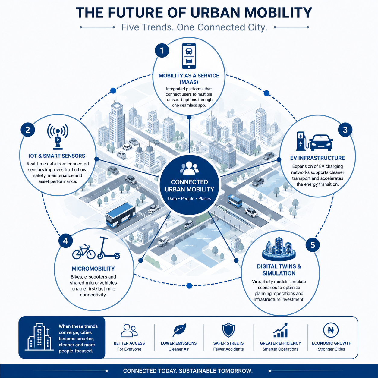
A traffic engineer in Lagos reviewing a new BRT corridor design in 2026 faces a different brief than the one a colleague received five years earlier. The client no longer just wants dedicated lanes and signal timing plans — they want real-time passenger data feeds, integration with a ride-hailing API, and a corridor that can report its own pavement condition to a maintenance dashboard. This is the practical face of urban mobility trends 2026: not a single breakthrough technology, but a convergence of sensor networks, shared mobility platforms, and data-driven planning that is changing how transport infrastructure gets designed, procured, and maintained across UK, UAE, and West African cities alike. This article covers the core drivers behind these shifts, the technical systems involved, the regulatory context in each region, and the practical challenges engineers are running into on live projects.
Urban mobility is the movement of people and goods within a city using an integrated mix of transport modes — road, rail, non-motorised transport, and increasingly, shared and autonomous systems — coordinated through data and infrastructure planning rather than each mode operating in isolation.
Urban Mobility Trends 2026: Quick Answer
Urban mobility trends 2026 centre on Mobility-as-a-Service (MaaS) platforms, IoT-enabled traffic sensors, electric vehicle charging infrastructure, and micromobility integration. Cities in the UK, UAE, and Nigeria are prioritising data-sharing standards between transport operators, retrofitting road corridors for EV load, and mandating digital twin models for major transit projects to reduce construction risk and improve long-term asset management.

What Is Driving Urban Mobility Trends in 2026
Three pressures are pushing cities to rethink mobility infrastructure at the same time. First, population density in cities like Lagos and Abuja continues to outpace road network expansion, forcing planners toward demand management rather than pure capacity addition. Second, national net-zero commitments in the UK and UAE are pulling transport electrification forward faster than most five-year infrastructure plans anticipated. Third, smartphone penetration has made real-time mobility data — GPS traces, fare card taps, ride-hailing trip logs — cheap to collect and genuinely useful for signal optimisation and route planning, where a decade ago it was expensive and sparse.
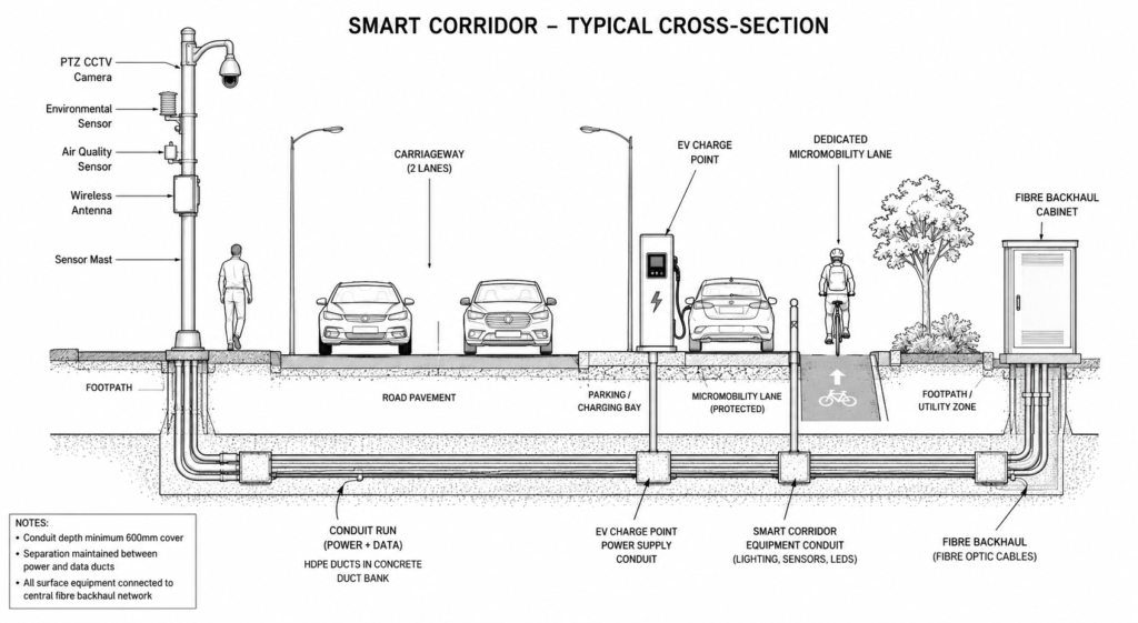
For a civil or transport engineer, this means the scope of a typical urban mobility brief has widened. You are no longer just sizing a carriageway or designing a junction — you are specifying conduit runs for sensor cabling, coordinating with telecoms providers on 5G small-cell placement, and building data-sharing clauses into procurement documents. Related planning work often falls under urban planning frameworks, which increasingly treat mobility corridors as data infrastructure as much as physical infrastructure.
Regional Variation in Adoption
The UK is furthest along on regulatory mandates, with local transport authorities required under Bus Service Improvement Plans to publish open real-time data feeds. The UAE, led by Dubai’s RTA, has moved faster on physical infrastructure — autonomous transit pilots and integrated fare systems across metro, bus, and marine transport are already operational. Nigeria’s larger cities are earlier in the curve, with Lagos’s BRT expansion and the Lagos Rail Mass Transit programme serving as the primary test beds for smart ticketing and vehicle tracking, overseen in coordination with COREN-registered engineering firms on the civil works side.
Why This Matters for Project Scoping
Engineers scoping a 2026 mobility project need to budget for data infrastructure line items that did not exist in a typical 2020 bill of quantities: fibre backhaul, edge computing cabinets at intersections, and API integration costs with third-party mobility operators. Skipping this at the scoping stage is the most common source of budget overrun on smart corridor projects — the civil works finish on schedule, but the technology layer runs six to nine months behind because it was never properly costed.
This scoping gap tends to show up in one of two places. Either the ducting and chamber layout is sized for today’s sensor count with no spare capacity for the next generation of devices, forcing a second dig within three or four years, or the procurement documents specify hardware without specifying the data contract that makes the hardware useful — a traffic sensor that reports to a proprietary dashboard nobody else can query is not much better than no sensor at all. A well-scoped brief separates these two elements clearly: physical provisioning (ducts, power, chambers) sized with 30 to 40% spare capacity, and a data specification (formats, access rights, retention periods) agreed before the tender goes out.
Core Technologies Behind Urban Mobility Trends 2026
Five technology categories account for most of the change engineers are seeing on live projects.
Data Platforms and Standards
Mobility-as-a-Service (MaaS) platforms combine public transit, ride-hailing, bike-share, and parking into a single booking and payment interface. From an infrastructure standpoint, MaaS requires standardised data formats — General Transit Feed Specification (GTFS) for schedules and GTFS-Realtime for live positions — which means new transit assets must be designed with data export capability specified in the contract from day one, not retrofitted afterward. Where a city has multiple operators publishing feeds in incompatible formats, the practical fix is a data aggregation layer procured separately from any single operator’s system, so the client retains control of the feed rather than depending on one vendor’s proprietary format.
IoT sensor networks now cover inductive loop replacements, radar-based vehicle counters, and air quality monitors mounted on street furniture. A single smart corridor in a mid-sized UK city might carry 40 to 60 sensor points feeding a central traffic management system, each requiring power, conduit, and a maintenance access plan that has to be coordinated with the highways design from the outset. Sensor selection also matters: radar-based counters tolerate heat and dust far better than older inductive loops, which is why several Gulf-region highway authorities have shifted specification toward radar as the default for new installations rather than a premium option.
Physical Infrastructure Provisioning
Electric vehicle charging infrastructure is reshaping kerbside design. UK local authorities are mandating minimum charge-point ratios in new residential and commercial developments, while the UAE has set targets under its Dubai Clean Energy Strategy for public charging density along major corridors. This affects load calculations for local distribution networks and requires close coordination with utilities providers early in design — a coordination gap that has delayed several UAE retail-adjacent charging installations by over a year. Engineers should treat charge-point load as a phased demand curve rather than a fixed figure: a corridor specified for today’s EV adoption rate will likely need a second-stage transformer upgrade within five to seven years as fleet electrification accelerates.
Micromobility integration — e-scooters, e-bikes, and shared bicycle schemes — has pushed kerb geometry standards to include dedicated parking bays and protected lanes that did not exist in most highway design manuals a decade ago. Retrofitting these into existing streetscapes, particularly in dense West African urban cores with informal roadside trading, is proving one of the harder practical challenges of the trend.
A fifth, less visible category worth flagging is digital twin modelling for mobility corridors. Rather than a standalone technology, this is best understood as a coordination layer that sits on top of the other four — a live 3D model of the corridor, populated with sensor data, that lets planners simulate a signal timing change or an EV load increase before committing to it on the ground. Several UK local authorities now require a digital twin as a contract deliverable on major transit schemes, not just a design aid, because it gives the client an asset management tool that outlives the construction phase. For engineers, this means the survey and modelling data captured during design has to be structured for handover, not discarded once the drawings are issued.
Regulatory Context Across UK, UAE, and West African Markets
Regulatory frameworks for urban mobility remain fragmented, and engineers working across jurisdictions need to track three separate compliance pictures rather than assume convergence.
In the UK, the Construction (Design and Management) Regulations 2015 (CDM 2015) govern the health and safety planning obligations for any mobility infrastructure project, while highway design itself follows Design Manual for Roads and Bridges (DMRB) standards, increasingly cross-referenced with Eurocodes for structural elements like footbridges and gantries associated with smart corridors. Local transport authorities also enforce their own data governance rules under UK GDPR for any personally identifiable mobility data collected through fare systems or ride-hailing integrations.
In the UAE, the General Civil Aviation Authority (GCAA) governs airspace-adjacent mobility infrastructure such as drone delivery corridors near airports, while Dubai Municipality sets civil works standards for road and utility coordination. The RTA additionally issues its own technical specifications for smart transit integration that supersede general municipal guidance on transit-specific projects.
In Nigeria and wider West Africa, COREN registration remains the baseline requirement for engineers signing off structural and civil elements of mobility projects, while the National Environmental Standards and Regulations Enforcement Agency (NESREA) governs environmental impact assessments for large-scale transit corridors. The Nigerian Civil Aviation Authority (NCAA) becomes relevant where mobility projects intersect with airport access roads or drone-based logistics pilots, an increasingly common feature of last-mile freight planning in Lagos.
Common Challenges and Cost Factors in Urban Mobility Projects
Three recurring problems account for most of the cost overruns engineers report on urban mobility trends 2026 projects.
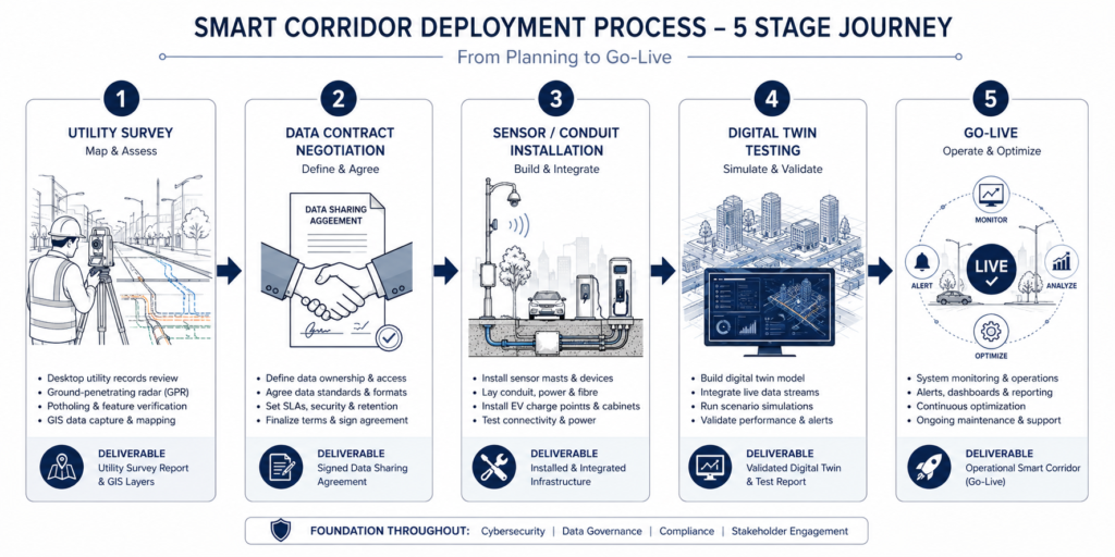
Data ownership disputes between public transit authorities and private mobility operators frequently stall MaaS integration well past the civil works completion date. A local authority may complete a smart corridor on time, only to spend an additional eight to twelve months negotiating data-sharing terms with a ride-hailing operator before the platform can go live — a delay that has nothing to do with construction quality but everything to do with contract drafting at the procurement stage.
Retrofitting sensor and charging infrastructure into existing streetscapes costs considerably more than specifying it into new-build corridors. Trenching for conduit in an established urban core with unmapped legacy utilities — a common condition in older parts of Lagos and several UK city centres — can add 15 to 25% to the civil works budget once utility strikes and reinstatement costs are factored in.
Power resilience for IoT sensor networks and EV charging is frequently underspecified at design stage. A traffic management system that loses power during a grid fault in Lagos, where load-shedding remains a live operational risk, needs battery backup or solar-assisted supply built into the specification — not added as a change order after the first outage takes the system down.
A fourth, quieter cost factor is maintenance staffing. A smart corridor with 50 sensor points and a dozen EV chargers needs a technician team trained to diagnose faults across both civil and electronic systems — a skill set that most highways maintenance contracts in the region do not yet cover. Clients frequently discover this gap only after the first sensor outage, when the incumbent maintenance contractor confirms they can fix a pothole but not a failed inductive loop or an offline charge-point controller. Building a technology maintenance schedule into the same contract as the civil works maintenance plan, with named responsibility for each asset type, avoids a costly second procurement exercise once the corridor is already live.
Best Practices for Planning Urban Mobility Projects
You can avoid most of the delays described above by front-loading the following into your design and procurement process.
- Specify data export formats (GTFS, GTFS-Realtime, open APIs) in the contract before construction begins, not as a post-completion addition.
- Budget for a dedicated power resilience allowance covering battery backup for every sensor cabinet and charge point on the corridor.
- Commission a utility survey using ground-penetrating radar before trenching in any established urban core to reduce the risk of unplanned reinstatement costs.
- Build data-sharing terms with third-party mobility operators into the procurement stage, with named responsible parties and a target go-live date tied to contract milestones.
- Design kerb geometry for micromobility parking and protected lanes from the concept stage, rather than retrofitting after a public complaint about pavement obstruction.
Where possible, request a digital twin model of the corridor before construction starts. This lets you test sensor placement, EV load scenarios, and traffic flow changes against the physical design before committing to trenching and civil works — a practice increasingly standard on projects connected through connected infrastructure planning frameworks, and one that pairs well with broader smart cities strategy documents where a city already has one in place.
You should also treat the sensor network itself as an asset with a lifecycle, not a one-off installation. Specify a five-year replacement cycle for outdoor sensor hardware exposed to heat and humidity — conditions that shorten component life significantly faster in Lagos or Dubai than in a UK climate — and budget for firmware updates as an ongoing operating cost rather than a capital one. Coordinating this with the utility provider’s own IoT network rollout, where one exists, can reduce duplicate conduit runs and shared pole-mounting costs considerably.
Frequently Asked Questions About Urban Mobility
Q: What is urban mobility in civil engineering terms?
A: Urban mobility refers to the coordinated movement of people and goods within a city across multiple transport modes — road, rail, non-motorised, and shared systems — planned and operated using integrated data rather than isolated mode-by-mode infrastructure. It typically falls under a city’s wider urban planning and transport engineering function.
Q: How does a Mobility-as-a-Service platform work?
A: A MaaS platform aggregates transit schedules, ride-hailing availability, and shared bike or scooter access into a single booking and payment app. It relies on standardised data feeds, most commonly GTFS and GTFS-Realtime, published by each transport operator, which the platform combines to suggest routes and process a single fare across multiple providers.
Q: What are the main urban mobility trends 2026 requirements for new road corridors?
A: New corridors increasingly require conduit and power provisioning for IoT sensors, EV charge-point allowances sized to projected fleet electrification rates, dedicated micromobility lanes and parking bays, and contractual data export specifications tied to GTFS or open API standards. Requirements vary by jurisdiction, with UK authorities generally furthest ahead on mandatory data-sharing clauses.
Q: How much does smart mobility infrastructure retrofitting cost compared to new-build?
A: Retrofitting sensor, conduit, and charging infrastructure into an existing urban corridor typically costs 15 to 25% more than specifying the same systems into a new-build project, primarily due to unmapped legacy utilities, trenching disruption, and reinstatement costs in established streetscapes.
Q: What is the difference between urban mobility and urban infrastructure?
A: Urban mobility specifically covers the movement of people and goods — transport modes, transit systems, and the data layer coordinating them. Urban infrastructure is the broader category that also includes utilities, drainage, telecommunications, and public realm assets not directly tied to movement, though the two increasingly overlap in urban infrastructure planning documents.
Urban mobility trends 2026 are less about a single new technology and more about infrastructure projects now needing a data layer specified with the same rigour as the concrete and steel. Engineers who budget for power resilience, data-sharing contracts, and utility surveys at the scoping stage avoid the delays that catch out projects treating these as afterthoughts. Whether you’re planning a BRT corridor in Lagos, a smart junction retrofit in a UK city centre, or an integrated transit hub in the UAE, the fundamentals hold: design the physical and digital systems together, and register the data governance terms in your contracts before construction starts, not after. If your team is scoping a mobility project and needs support integrating sensor networks or MaaS data requirements into your civil design, StruviaCore’s transport engineering team can help you build that specification from day one.
Leave a Reply