

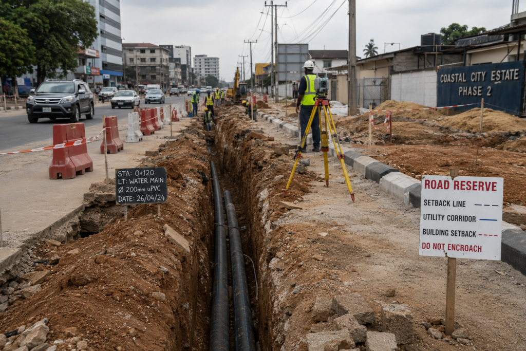
A developer in Dubai submits a mixed-use tower for approval and the plan bounces back twice — first for a setback miscalculation against the road reserve, then for a drainage strategy that ignores an adjacent stormwater easement. Neither issue was a design flaw. Both were checklist failures. An urban planning checklist exists precisely to catch these gaps before a submission ever reaches a planning authority’s desk, saving weeks of resubmission cycles on projects where the clock is already tight.
This article sets out what belongs in that checklist, why each item matters structurally and administratively, and how engineers working across the Gulf, Nigeria, and the UK can adapt it to local planning frameworks. You will get a working sequence you can apply on your next submission, not a generic list of good intentions.
Urban Planning Checklist: Quick Answer
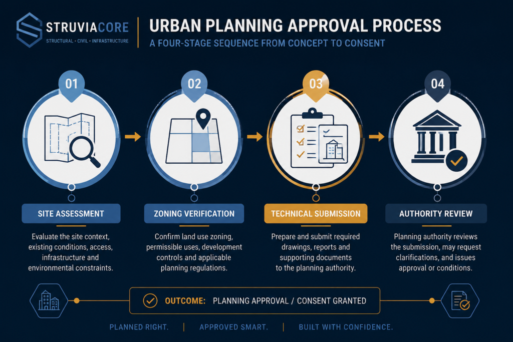
An urban planning checklist is a structured verification list covering zoning compliance, land use classification, infrastructure capacity, environmental clearance, and utility coordination that a project must satisfy before a planning authority grants approval. It typically spans site assessment, regulatory review, and technical submission stages, and prevents costly resubmissions caused by overlooked local requirements.
What an Urban Planning Checklist Actually Covers
Before going further, it helps to be clear on what urban planning covers as a discipline, since the checklist only makes sense against that backdrop. An urban planning checklist is not a single document you fill in once. It is a layered verification process that runs from the earliest site assessment through to final authority sign-off, and each layer answers a different regulatory question. At the base sits land use compatibility: does the proposed development match the zoning classification assigned to the parcel under the local master plan? In Dubai, this means cross-checking against the Dubai Municipality zoning regulations and, where relevant, the Dubai 2040 Urban Master Plan’s designated urban centres. In Lagos, it means confirming the plot’s classification under the Lagos State Physical Planning Permit Authority (LASPPPA) framework before a single structural drawing is produced.
Above land use sits infrastructure capacity — road access, drainage discharge points, water supply connection, and power load availability. A checklist that skips this layer produces designs that pass structural review but stall at the utility coordination stage, sometimes for months. Above that sits environmental and heritage clearance, which on Gulf coastal sites frequently involves marine environment assessments, and in UK conservation areas triggers a separate consultation under the Town and Country Planning Act.
Zoning and Land Use Verification
Zoning verification is the item most frequently rushed, and the one that causes the most expensive rework. You need the current zoning classification, the permitted building envelope (height, plot ratio, setbacks), and any overlay restrictions such as airport height cones or view corridors. Abu Dhabi’s Department of Municipalities and Transport publishes plot-specific development regulations that supersede general zoning defaults, so relying on a generic zoning map without pulling the plot-specific data sheet is a common and avoidable error. The same discipline applies in reverse in the UK, where a site’s allocation under the local authority’s adopted local plan can differ meaningfully from what a national planning policy overview suggests is permitted, particularly on sites within a designated conservation area or green belt boundary.
Regulatory Body Confirmation
Every jurisdiction has more than one authority with a say in approval. A UAE project might need sign-off from Dubai Municipality, Dubai Civil Defence for fire access, and Trakhees if the site sits within a free zone. A Nigerian project touching a federal road reserve needs Federal Ministry of Works input alongside state planning approval. List every authority with jurisdiction before you draft anything — discovering a missing consent at submission stage adds four to eight weeks to most Gulf approval timelines.
Building the Technical Submission Package
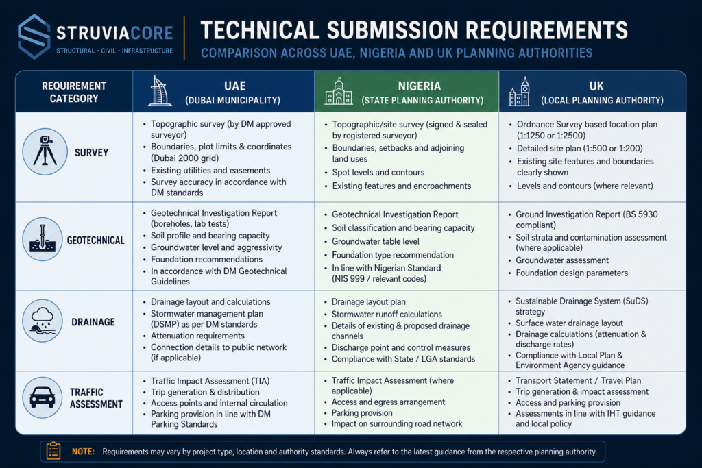
Once zoning and authority requirements are confirmed, the checklist moves into the technical submission package — the set of drawings, reports, and calculations a planning authority reviews before granting approval. This is where structural and civil input carries the most weight, because the technical package is what turns a conceptual layout into an approvable scheme. Authorities reviewing the package are not assessing design intent — they are checking whether the numbers you have submitted stand up against their own capacity data, which is why every figure in the package needs a traceable source rather than a design assumption.
A complete package generally includes a site survey with levels referenced to the local datum, a geotechnical desk study or full soil investigation report, a drainage strategy showing discharge rates against the receiving system’s capacity, a traffic impact assessment where the development exceeds threshold trip generation — worth reading alongside our urban mobility guide if the site sits near a planned transit corridor, and structural concept drawings sufficient to demonstrate the scheme is buildable within the approved envelope. Missing any one of these is the single most common reason a first submission gets rejected outright rather than returned with comments.
Drainage and Stormwater Coordination
Drainage strategy is where checklists fail most often on Gulf projects, because flash rainfall events, while infrequent, generate discharge volumes the receiving network was never sized for. Your submission needs to demonstrate attenuation capacity — typically a minimum on-site storage volume calculated against a 1-in-10 or 1-in-100 year storm event depending on the authority’s design standard — and confirm the outfall point has spare capacity. Skipping the outfall capacity confirmation is the most common cause of drainage-related resubmission.
Site Survey and Datum Referencing
An overlooked but frequent source of rejection is a site survey referenced to the wrong datum, or one that predates a recent road realignment. Authorities cross-check submitted levels against their own benchmark network, and a survey more than a year or two old on a fast-changing urban edge site — common on the outskirts of Lagos and in newly released Dubai districts — can misstate finished ground level relative to the approved road level. Commission an updated topographic survey rather than relying on a survey produced for an earlier feasibility stage.
Utility Load Coordination
Power, water, and telecom load coordination needs sign-off from each utility provider before final submission, not after. In practice this means securing a No Objection Certificate (NOC) from the relevant provider confirming the site has, or will have, sufficient supply capacity for the proposed load. Projects that submit without these NOCs routinely sit in review queues while the authority waits on the same confirmations you could have obtained in parallel. Where a site also carries smart metering or shared-network requirements, our connected infrastructure guide covers how that coordination typically runs.
Regulatory Context Across Nigeria, the UK, and the Gulf
The core logic of an urban planning checklist — confirm land use, confirm infrastructure capacity, confirm regulatory consent, then submit — holds across jurisdictions, but the specific instruments differ enough that a template built for one market will misfire in another. In the UK, the Town and Country Planning Act 1990 and the National Planning Policy Framework set the statutory basis, and a local planning authority’s own local plan governs day-to-day decisions; RIBA Stage 2 and 3 outputs typically feed directly into a full planning application.
In Nigeria, urban planning approval runs through state-level authorities — LASPPPA in Lagos, the FCT Development Control Department in Abuja — and engineers registered with COREN are expected to seal structural submissions as part of the technical package. SURCON registration matters separately where the submission includes a land survey plan, since site plans require a licensed surveyor’s certification independent of the structural engineer’s input.
In the UAE, Dubai Municipality’s Dubai Building Permit System (formerly known through its DPS process) coordinates multi-authority review, while Abu Dhabi runs approval through the Department of Municipalities and Transport. Both emirates increasingly require BIM-based submissions for larger projects, meaning your checklist now needs an information management item — confirming model deliverables meet the authority’s required Level of Development before submission, not simply that drawings are complete.
These differences matter beyond terminology. A checklist item that reads “confirm zoning” means checking a plot-specific data sheet in Abu Dhabi, a district-level master plan overlay in Dubai, a state-issued C of O and approved layout in Lagos, and a local plan allocation in the UK — four different documents, four different issuing bodies, and four different timelines for obtaining them. Engineers moving between these markets on multi-country portfolios should build a jurisdiction column into their internal checklist template rather than assuming one sequence transfers directly. Estidama compliance in Abu Dhabi and equivalent sustainability overlays add a further layer that a generic checklist will miss entirely if it was built against a UK or Nigerian project as the baseline.
Common Mistakes and Cost Factors
The most expensive planning mistakes are rarely dramatic. They are quiet omissions that surface late. Underestimating setback requirements against a road reserve forces a redesign of the entire building footprint rather than a minor adjustment — on a mid-rise scheme this can cost several weeks of redesign fees plus resubmission delay. Submitting a drainage strategy without confirming outfall capacity produces the same effect: an approval that looked complete gets returned with a technical objection that requires new calculations.
Cost factors on the planning side break down into four categories you should budget for from the outset:
- Authority submission and processing fees, which scale with built-up area and vary significantly between Dubai, Abu Dhabi, and Nigerian state authorities
- Consultant fees for specialist reports — traffic impact assessments and environmental studies typically cost more than the geotechnical desk study that triggers them
- Resubmission delay costs, measured in holding costs on financed land rather than direct fees, which is why first-pass approval matters more than the submission fee itself
- NOC acquisition costs and timelines from utility providers, which on Gulf projects can add four to six weeks if not run in parallel with the main submission
A second recurring mistake is treating the checklist as a one-time exercise rather than a living document. Zoning regulations change, master plans get updated — Dubai’s 2040 plan has already triggered zoning revisions in several districts — and a checklist built two years ago against an outdated zoning map will misdirect an entire submission.
A third mistake, less discussed but just as costly, is sequencing the geotechnical investigation too late in the design programme. When soil investigation runs in parallel with, rather than ahead of, structural concept design, foundation type decisions get made on assumed bearing capacity rather than measured values. On sites with variable fill or reclaimed ground — common along Gulf coastal developments and parts of the Lagos lagoon fringe — this produces a foundation scheme that has to be redesigned once real borehole data comes back, which then cascades into a revised structural submission and a fresh round of authority review. Budgeting geotechnical investigation as the first technical activity, not a parallel workstream, avoids this entirely.
Best Practices: The Working Checklist
Use this sequence on your next submission rather than treating each item as optional — pair it with our broader urban planning guide if you’re building the checklist into a formal internal process. It reflects the order in which planning authorities actually expect information, not the order design work happens to produce it.
- Confirm the current zoning classification and permitted envelope directly from the authority’s plot-specific data sheet, not a general zoning map
- List every regulatory body with jurisdiction over the site, including fire, civil defence, and any free zone authority
- Commission a geotechnical desk study early enough that soil conditions inform the structural scheme before concept drawings are fixed
- Confirm drainage outfall capacity with the receiving authority before finalising the on-site attenuation strategy
- Request utility NOCs from power, water, and telecom providers in parallel with the technical submission, not after
- Verify BIM Level of Development requirements where the authority mandates model-based submission
- Cross-check heritage, marine, or environmental overlay restrictions specific to the site’s location
- Build a resubmission buffer of four to six weeks into the project programme regardless of how complete the first submission appears
Applying this sequence consistently is what separates a first-pass approval from a submission that cycles through two or three rounds of authority comments. Teams that treat the urban planning checklist as a front-loaded discipline rather than a box-ticking formality consistently shorten their approval timelines, and that time saving compounds across a multi-phase development.
You should also assign a single owner for the checklist rather than splitting it across disciplines with no coordination point. On most StruviaCore-reviewed projects, the delays that survive even a well-built checklist trace back to unclear ownership — the structural engineer assumes the architect has confirmed setbacks, the architect assumes the civil team has confirmed drainage capacity, and neither confirms it directly with the authority until the submission bounces. A named checklist owner, checking off each item against a dated source document rather than a verbal assumption, closes that gap.
Frequently Asked Questions About Urban Planning
Q: What is an urban planning checklist in civil engineering?
A: It is a structured verification list confirming that a proposed development complies with zoning classification, infrastructure capacity, environmental clearance, and utility coordination requirements before a planning authority reviews the submission. Engineers use it to sequence technical reports — geotechnical, drainage, traffic — so nothing critical is missing at first submission.
Q: How does the urban planning approval process work in Dubai?
A: Dubai Municipality coordinates multi-authority review through its building permit system, requiring zoning confirmation, technical drawings, and NOCs from utility providers and, where applicable, Dubai Civil Defence. Larger projects increasingly require BIM-based submissions meeting a specified Level of Development before approval is granted.
Q: What are the urban planning requirements for a mid-rise development in Lagos?
A: A mid-rise submission in Lagos requires approval from LASPPPA, a certified survey plan from a SURCON-registered surveyor, structural drawings sealed by a COREN-registered engineer, and confirmation that the plot’s zoning classification permits the proposed height and use. Drainage capacity against the local stormwater network is reviewed as part of the same submission.
Q: How much does urban planning approval cost?
A: Costs vary by built-up area and jurisdiction, but budget for authority processing fees, specialist consultant reports such as traffic impact assessments, and a contingency for resubmission delay, which typically costs more in holding charges than the direct fees themselves. Utility NOC acquisition can add separate costs of several thousand dollars on larger Gulf projects, and engaging a specialist consultant early to run parallel NOC applications is usually cheaper than absorbing the delay cost of a late request.
Q: What is the difference between zoning verification and a full planning submission?
A: Zoning verification is an early-stage check confirming what a plot legally permits — use, height, plot ratio, setbacks — before design begins. A full planning submission is the complete technical package, including drawings, reports, and NOCs, submitted for the authority’s formal approval decision once the design is developed against that confirmed zoning.
An urban planning checklist works because it forces the sequence that planning authorities actually expect: zoning confirmed first, infrastructure capacity verified second, regulatory consents secured in parallel, and only then a technical submission built on solid ground. Skipping any layer does not save time — it defers the delay to a later, more expensive stage of the project. Whether you are coordinating a Dubai Municipality submission, a LASPPPA approval in Lagos, or a UK local planning application, the discipline is the same: confirm before you design, not after.
If your team is preparing a submission and needs geotechnical, drainage, or structural input built around a specific authority’s requirements, StruviaCore’s structural engineering services can help you sequence the technical package correctly the first time.
Leave a Reply