
META DESCRIPTION: Water resources trends 2026 are reshaping how engineers design drainage, flood systems, and urban water networks. Discover what’s changing — and how to stay ahead.
Water Resources Trends 2026: What Civil Engineers Need to Know
In the wet season of 2024, parts of Lagos saw floodwater inundate Lekki-Epe Expressway for the third consecutive year. Further north, Abuja’s drainage channels — designed decades ago for a city a fraction of its current size — were overwhelmed within hours of a single storm event. These failures are not anomalies. They are symptoms of a water infrastructure gap that is widening faster than the profession is closing it.
The water resources engineering discipline is at a turning point in 2026. Climate variability, rapid urbanisation, aging infrastructure, and new digital tools are all converging to reshape how engineers plan, design, and operate water systems. Whether you are working on a stormwater retention pond in Port Harcourt or a cross-border river basin study, the trends redefining this field will affect your next project. This article breaks down the six most significant water resources trends 2026 is delivering — and explains what each means for engineering practice on the ground.
Water resources trends 2026: Quick Answer
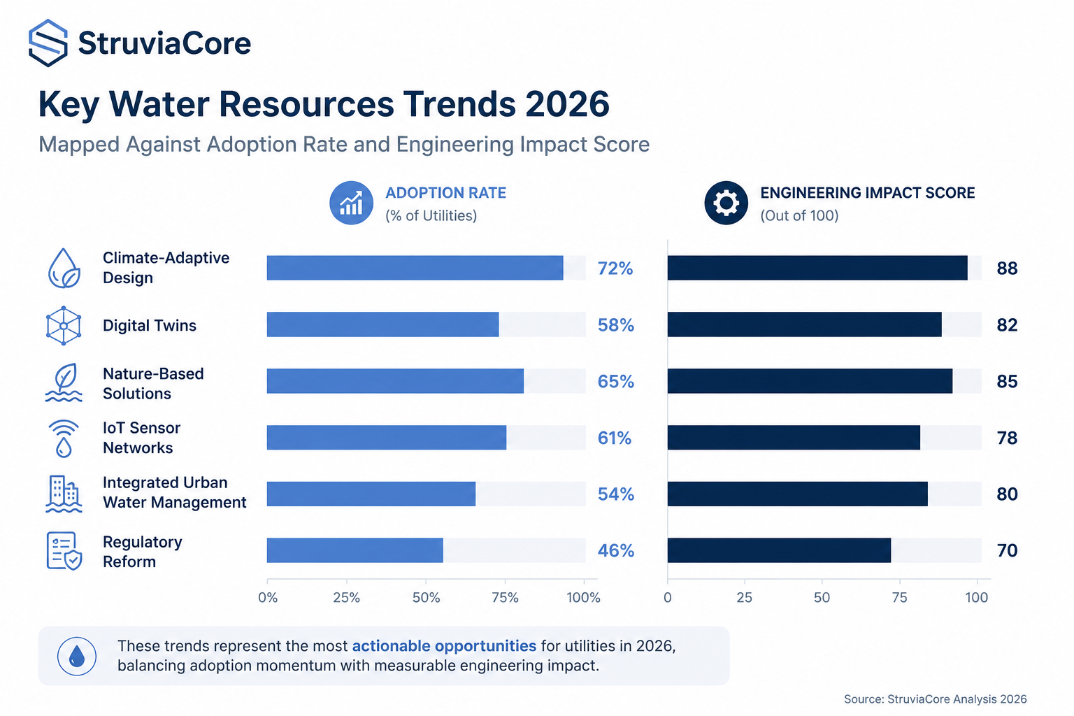
Water resources trends 2026 centre on climate-adaptive design, real-time sensor networks, nature-based drainage solutions, digital twin modelling, integrated urban water management, and tightened regulatory standards for flood risk. Engineers are moving away from single-purpose infrastructure toward systems that serve multiple hydrological functions simultaneously across a project’s full lifecycle.

What Water Resources Engineering Actually Covers in 2026
Water resources engineering is the branch of civil engineering concerned with the controlled management of water in the natural and built environment — including catchment hydrology, surface water drainage, river hydraulics, groundwater systems, flood risk management, water supply, and irrigation infrastructure. It draws on fluid mechanics, soil science, environmental regulation, and increasingly, data analytics.
The scope has expanded significantly. A decade ago, water resources work on a typical Nigerian development project meant sizing drainage channels to a return period — often 1-in-10 or 1-in-25 years — using rational method calculations and standard BS EN 752 tables for urban drainage. That approach still has a place, but it is no longer sufficient on its own.
Today’s water resources engineer must understand how climate projections alter design rainfall intensities, how downstream catchments interact with upstream interventions, and how a drainage system will perform not just at commissioning but 30 to 50 years into its operational life. The shift is from point-in-time design to whole-system lifecycle thinking.
This expanded scope connects directly to hydraulic engineering principles, where flow behaviour, channel geometry, and energy dissipation remain the physical backbone of any water management solution. What 2026 is adding is a new layer of tools, regulations, and design philosophy on top of that foundation.
The Distinction Between Hydrology and Hydraulics
Engineers entering the field sometimes conflate hydrology with hydraulics. Hydrology is the study of water movement through the natural environment — how rainfall becomes runoff, how catchments respond to storms, how groundwater recharges. Hydraulics is the mechanics of water in motion through engineered channels, pipes, and structures.
Both disciplines feed the same design process, but they answer different questions. Hydrology tells you how much water arrives. Hydraulics tells you what happens to it once your infrastructure intercepts it. In 2026, the integration of the two — through continuous simulation models rather than sequential manual calculations — is one of the defining shifts in water resources practice.
Regulatory and Standards Context
In Nigeria, water resources practice operates within a framework that includes standards from the Federal Ministry of Water Resources, state-level drainage masterplans, and adopted international codes including BS EN 752 (drain and sewer systems outside buildings), BS 8005 (sewerage), and ISO 24500-series standards for water services. The Council for the Regulation of Engineering in Nigeria (COREN) requires that all water infrastructure designs be signed off by a registered engineer.
Globally, the ISO 31000 risk management framework and the UN Sustainable Development Goal 6 — clean water and sanitation for all — are increasingly referenced in donor-funded and multilateral infrastructure projects. Engineers working on projects with international financing should expect these frameworks to appear in project briefs from 2026 onward.
Trend 1: Climate-Adaptive Design Is Now the Baseline, Not the Add-On
The single most consequential shift in water resources engineering in 2026 is the movement of climate change adaptation from optional consideration to design baseline. For years, it was common practice to design drainage and flood control infrastructure using historical rainfall data from NIMET records or gauging stations, then apply a modest climate uplift factor of perhaps 10–15% on peak flows. That approach is now considered inadequate for projects with a design life beyond 20 years.
The reason is straightforward: historical data describes a climate that no longer exists. West Africa has seen measurable increases in rainfall intensity in short-duration storm events — the 30-minute and 60-minute bursts that overwhelm urban drainage — while mean annual rainfall patterns in some northern regions have shifted toward longer dry spells punctuated by higher-intensity events. Designing to historical return periods without a forward-looking climate adjustment builds in vulnerability from day one.
In 2026, leading consultancies are applying IPCC AR6 regional climate projections to derive adjusted Intensity-Duration-Frequency (IDF) curves for specific project catchments. For a 1-in-100 year storm event in Lagos, recent studies suggest design rainfall intensities may increase by 20–35% by mid-century under intermediate emissions scenarios. This has direct consequences for culvert sizing, detention basin volumes, and road drainage design.
Practical implication for engineers: do not rely solely on historic gauged data or standardised rainfall tables. Commission or obtain climate-adjusted IDF curves from recognised sources — the Lagos State government’s 2021 drainage masterplan, for example, already incorporates these adjustments. Where local climate data is limited, apply the Clausius-Clapeyron scaling relationship (approximately 7% increase in extreme rainfall intensity per 1°C of warming) as a defensible first-order adjustment.
This trend also connects to climate resilience examples from infrastructure projects elsewhere in Africa and Southeast Asia, where adaptive design standards are now contractually mandated on World Bank and AfDB-funded schemes.
Trend 2: Nature-Based Solutions Are Moving from Pilots to Mainstream Infrastructure
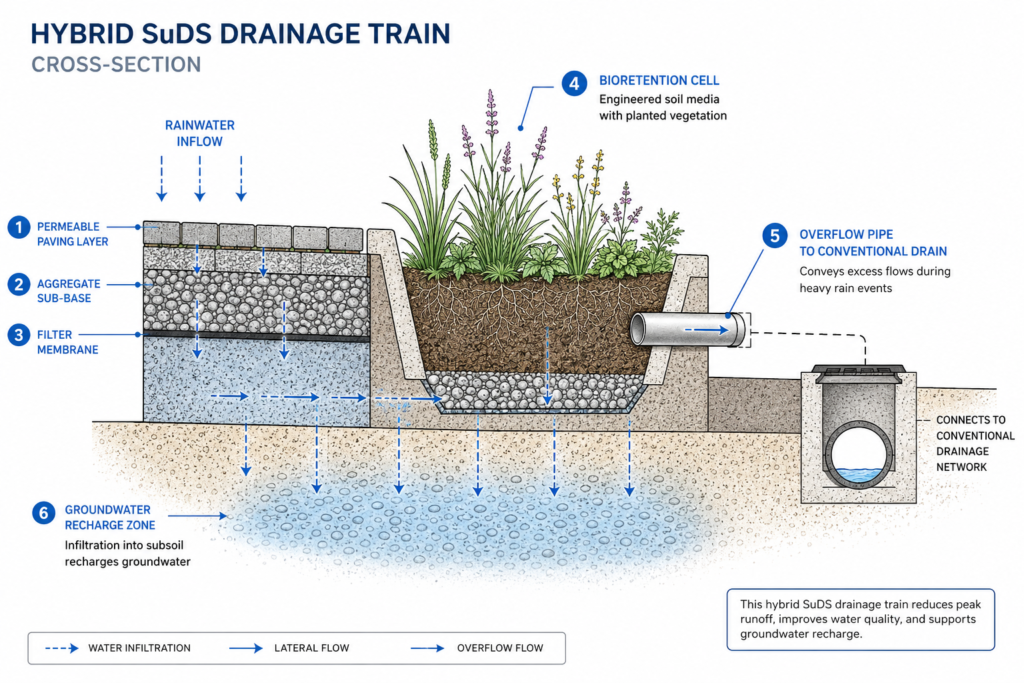
Nature-based solutions (NbS) — green roofs, constructed wetlands, permeable paving, bioswales, urban tree canopy, and floodplain restoration — have been discussed in academic and policy circles for over a decade. In 2026, they are entering mainstream engineering procurement on development projects of meaningful scale.
The driver is partly economic and partly regulatory. Grey infrastructure — concrete channels, underground culverts, pump stations — carries high capital costs, substantial maintenance obligations, and zero co-benefits beyond drainage function. A well-designed bioretention system, by contrast, can achieve 40–60% reduction in peak runoff volume from small storm events, reduce urban heat island effect, improve groundwater recharge, and support biodiversity — all within the same land footprint.
In the Lagos context, the Lagos State Urban Drainage Master Plan acknowledges NbS as a supplementary strategy for new residential estates in areas like Ibeju-Lekki and Epe where conventional grey drainage at scale is cost-prohibitive. The approach taken is typically a hybrid: NbS systems handle frequent, low-magnitude events (the 1-in-2 and 1-in-5 year storms) while conventional drainage handles the extreme events that would overwhelm any natural system.
Engineers specifying NbS in 2026 should be aware that CIRIA’s SuDS Manual (C753) remains the primary technical reference for Sustainable Drainage Systems design in countries that follow British standards. It provides specific guidance on hydraulic design, water quality treatment trains, and maintenance protocols. Nigeria has no equivalent national SuDS standard yet, which means engineers must exercise professional judgment in adapting CIRIA guidance to local soil conditions, rainfall regimes, and maintenance realities.
Understanding how these solutions integrate into urban fabric requires a broader view of urban infrastructure systems, where water, roads, utilities, and green space increasingly need to be designed as a coordinated network rather than independent silos.
Trend 3: Digital Twins and Real-Time Sensor Networks Are Transforming Operations
A digital twin in water resources engineering is a dynamic computational model of a physical water system — a river basin, a drainage network, or a water treatment plant — that updates continuously using real-time sensor data. The model mirrors what is happening in the physical system at any given moment, enabling operators to run predictive scenarios and respond to events before they escalate.
This is no longer a research concept. Several major cities globally are operating digital twin flood management systems, and the technology is entering West African infrastructure discourse through international development projects. The mechanics of how digital twins function in engineering are worth understanding before the technology becomes a client expectation on your next project — the digital twins guide covers the broader principles applicable across engineering disciplines.
In practical water resources terms, a digital twin for urban drainage would integrate: real-time rainfall radar data, flow sensors at key points in the drainage network, ground level surveys, and a hydrodynamic model (typically built in software such as SWMM, MIKE FLOOD, or InfoWorks ICM). The model runs continuously in the background. When an approaching storm is detected, the system can simulate network performance under forecast rainfall and flag which culverts or channels are likely to surcharge — giving operators a 2–4 hour window to take protective action.
IoT Sensor Deployment in Water Networks
The enabling technology for real-time digital twins is the Internet of Things (IoT) sensor network. Low-cost ultrasonic flow meters, pressure transducers, and water quality probes can now be deployed at drainage infrastructure nodes for a fraction of the cost of a decade ago. Solar-powered, LoRaWAN-connected sensors operate independently of mains power and cellular networks — an important consideration in areas where both are unreliable.
The IoT in engineering context is maturing rapidly, and water utilities are among the earliest adopters. Engineers specifying sensor systems in 2026 should require data transmission protocols that comply with ISO/IEC 30141 (IoT reference architecture) and specify minimum sensor accuracy ratings — typically ±2% of reading for flow measurement in drainage applications.
Data Management and Model Validation
A digital twin is only as reliable as the underlying model and the data feeding it. Two common failures in early implementations have been poor model calibration against observed data and sensor drift that goes undetected over time. Engineers specifying or commissioning digital twin systems should require: documented model calibration against at least three historic storm events with measured flow data; automatic sensor health checks with anomaly alerts; and a defined maintenance protocol for sensor cleaning and recalibration at intervals not exceeding 12 months.
Trend 4: Integrated Urban Water Management Is Replacing Sectoral Thinking
Historically, urban water systems were designed and managed in isolation: the drainage engineer handled stormwater, the water supply engineer handled potable distribution, the sanitation engineer handled sewers, and never the three met in the same design meeting. This sectoral approach produced cities where stormwater drains into sewers that were not designed for the combined load, where water supply networks leak 30–40% of treated water before it reaches the consumer, and where reclaimed wastewater — a potentially valuable resource — is discharged to sea.
Integrated Urban Water Management (IUWM) treats the city as a water catchment in its own right, where all flows — rainfall, supply water, greywater, blackwater, groundwater — are managed as part of a single system. In engineering terms, this means coordinating drainage masterplans with water supply network models, sizing infrastructure for future population projections rather than current demand, and identifying where reclaimed water can substitute for potable supply in non-potable applications such as irrigation and toilet flushing.
For cities like Abuja, where the National Water Rehabilitation Project has repeatedly fallen short of its water supply targets, IUWM offers a framework for closing the gap between supply and demand without requiring equivalent increases in raw water abstraction. Several pilot projects under the Federal Ministry of Water Resources have explored aquifer storage and recovery — injecting treated water into groundwater systems during the wet season for extraction during the dry season — as a form of city-scale water banking.
Engineers working within this framework need to be comfortable operating across the traditional disciplinary boundary between surface water and groundwater. Groundwater levels affect drainage system performance, particularly in low-lying coastal cities. Understanding this interaction is part of good geotechnical and hydrological practice — as explored in geotechnical engineering fundamentals.
Challenges, Cost Drivers, and Common Design Mistakes
Understanding the trends is one thing. Navigating the practical obstacles that prevent good water resources engineering from being executed on real projects is another matter entirely.
Data scarcity remains the most persistent challenge in sub-Saharan Africa. Nigeria has approximately 400 active river gauging stations — a density of roughly one station per 2,300 km² of catchment area, against a recommended density of one per 300–500 km² for reliable flood frequency analysis. Engineers routinely work with incomplete flow records, short periods of record, and gauging stations that have been inactive for years. The result is significant uncertainty in design flood estimates that no amount of sophisticated modelling can fully overcome.
Construction quality is the second major risk to designed performance. A culvert sized correctly in hydraulic calculations delivers its design flow capacity only if it is built to the specified invert levels and alignment, and kept free of siltation and debris. Regular inspection and maintenance — often absent from Nigerian infrastructure budgets — is not a luxury; it is the mechanism by which the investment in good design is protected. A 900mm diameter reinforced concrete pipe culvert blocked by silt to 60% of its cross-section has an effective flow capacity closer to 25% of its design value.
A third common mistake is designing drainage in isolation from road levels. On many new residential estate roads in Nigeria, engineers finalise road levels before the drainage scheme is developed, and the drainage engineer is then handed a geometry that produces adverse gradients or creates sump conditions where water cannot flow to any outlet. Drainage and road design must proceed concurrently, not sequentially.
Finally, the underestimation of sedimentation rates in open channels is endemic. Design calculations frequently assume clean water flows, but Nigerian stormwater carries significant suspended sediment loads — particularly from construction sites and bare laterite soils. Channels designed without adequate freeboard and sediment traps silt up within 2–3 rainy seasons, reducing capacity and requiring costly intervention.
Best Practices for Water Resources Engineering in 2026
The following practices reflect current standards of care for water resources design projects. They are not exhaustive, but they represent the minimum threshold for work that will perform reliably and withstand scrutiny from COREN, client engineers, and international reviewers.
Before you begin design, verify the catchment boundary and confirm it against available topographic data or a current digital elevation model. Assumptions about catchment area are among the most consequential inputs to any hydrological calculation — an error of 15% in catchment area propagates directly into a 15% error in peak flow at the 1-in-100 year level.
Use a minimum of two independent hydrological methods to estimate peak design flows and compare results. The Rational Method remains appropriate for small urban catchments under 2 km², but should be cross-checked against the FSR Flood Studies Report methods or the UK Flood Estimation Handbook (FEH) regional regression equations for larger catchments. Where these produce materially different results, understand why before proceeding.
You should document all design assumptions explicitly. A design report that states “a runoff coefficient of 0.75 was applied” without recording how that value was derived — by what land use classification, with what source — cannot be audited, updated, or defended. Future engineers will be working with your design for decades.
Specify materials to named standards. Concrete pipes should conform to BS EN 1916 or NIS equivalents. Reinforced concrete box culverts should be designed to BS 5400 or BS EN 1992. Flexible pipes in permeable pavement systems should meet BS EN 13252. Do not leave material specification to the contractor’s discretion on safety-critical drainage elements.
Include a maintenance schedule in every drainage design report. Specify inspection frequency (at minimum twice yearly — before and after the wet season), cleaning methods, and the observable indicators of reduced performance that should trigger intervention. This information belongs in the design documentation, not as an afterthought in the operation and maintenance manual that nobody reads.

Frequently Asked Questions About Water Resources
Q: What is water resources engineering in civil engineering?
A: Water resources engineering is the civil engineering discipline that manages the movement, storage, distribution, and quality of water in both natural and built environments. It includes flood risk management, urban stormwater drainage design, river engineering, dam and reservoir design, water supply systems, and irrigation infrastructure. In Nigeria and West Africa, it most commonly intersects with urban drainage, flood control, and potable water supply projects.
Q: What are the water resources trends 2026 engineers should know?
A: The six most significant water resources trends in 2026 are: climate-adaptive design using forward-looking IDF curves rather than historic-only data; nature-based and sustainable drainage solutions entering mainstream procurement; digital twin modelling systems fed by real-time IoT sensor networks; integrated urban water management that treats stormwater, potable supply, and sanitation as a single system; tightened regulatory standards for flood risk disclosure on development projects; and increased adoption of continuous simulation hydrodynamic models in place of simplified peak-flow methods.
Q: How do you design for climate change in a water resources project?
A: Start by obtaining or deriving climate-adjusted Intensity-Duration-Frequency curves for your project location using IPCC AR6 regional projections or published national climate studies. Apply a minimum climate uplift of 20% on design rainfall intensities for projects with design lives exceeding 25 years in West Africa, unless project-specific climate data justifies a different value. Design detention and attenuation structures with additional freeboard to accommodate uncertainty, and where possible use adaptive design — infrastructure that can be upscaled without complete rebuilding if climate impacts exceed projections.
Q: What is the difference between hydrology and hydraulics in drainage design?
A: Hydrology quantifies how much water a catchment generates — it answers the question of volume and timing of runoff from a given rainfall event. Hydraulics determines how that water moves through pipes, channels, culverts, and open watercourses — it answers the question of velocity, water depth, pressure, and energy. In drainage design, hydrology produces the design flow rate and hydraulics produces the pipe or channel dimensions. Both are required; neither replaces the other.
Q: What codes and standards apply to water resources design in Nigeria?
A: Water resources design in Nigeria references BS EN 752 for urban drainage systems, BS EN 1916 for concrete pipes, BS 8005 for sewerage systems, and Lagos State drainage masterplan guidance where applicable. Hydrological methods are typically drawn from the UK Flood Studies Report or Flood Estimation Handbook, adapted to local conditions. COREN registration is mandatory for signing off any water infrastructure design. International projects funded by multilateral donors may additionally require compliance with ISO standards and World Bank environmental and social framework requirements.
What 2026 Demands From Water Resources Engineers
The water resources trends 2026 is delivering are not abstract. They are showing up in project briefs, client expectations, regulatory requirements, and the post-construction performance of infrastructure that was designed under assumptions that no longer hold.
Climate adaptation is not a future consideration — it is the correct design basis today. Nature-based solutions are no longer experimental; they are cost-competitive on the right projects. Digital tools, from hydrodynamic models to IoT sensor networks, are shifting from specialist capability to standard practice. And integrated thinking across drainage, supply, and sanitation is producing better urban water outcomes where it is applied.
The engineering fundamentals have not changed. What has changed is the context within which you apply them, the tools available to you, and the consequences of getting it wrong. If you are working on water resources infrastructure and want technical input grounded in current practice, StruviaCore’s civil engineering team works across drainage design, flood risk assessment, and water infrastructure planning. Explore our water resources services or contact us to discuss your project.
Leave a Reply